VOOZH about

URL: https://pahar.in/

⇱ MCADD by PAHAR – Explore two centuries of Himalayan exploration, scholarship & discovery


Skip to content
6,290 Books
850 Journals
3,664 Maps
631 Photos
25+ Countries Covered
618AD-2022 Era Covered

Explore two centuries of Himalayan exploration, scholarship & discovery

Try:

Our Projects

Original research and creative work by the PAHAR team

◆ PAHAR PROJECT

Himalayan Encounters: Returning the Past to Where It Belongs

A Project by the PAHAR Foundation Some ideas take root in a single, unguarded moment. In September 2015, Prof. Shekhar Pathak, founder of the People’s Association for Himalaya Area Research (PAHAR), was in Munich attending a symposium centered on the Schlagintweit brothers’ 19th-century expeditions to High Asia. The symposium, built around a major display of […]

Read More

◆ PAHAR PROJECT

Improved Uttarakhand Map

  Preparation of a High-Quality Uttarakhand State Map by Bhupen Mehta  Why was there a need for a good map of Uttarakhand State, India after it became a new state on Nov. 11, 2000 It was sometime in December 2000, when Professor R. Prabhakar, Mr. E Somnathan and I were on a study trip to Uttaranchal […]

Read More

◆ PAHAR PROJECT

William Moorcroft–Himalayan Traveller Extraordinaire

Of all the 19th-century Himalayan travellers, no one left as immense a volume of informative material as William Moorcroft. Moorcroft, a surgeon, the first Englishman to qualify as a professional veterinarian, and Superintendent of the Hon’ble East India Company’s military stud farm, travelled supposedly in search of breeding stock for the stud. But his interest […]

Read More


Discoveries from the Archive

Maps Geography

Memoir of a Map of Hindoostan : A testament of geographical knowledge

Author
James Rennell
Year
1793
Region
India (Bengal and Bihar prominantly)

Key Insights

A map is always something more than just a map; it helps define a country. You cannot proceed far in the memoir without understanding that for Rennell, the term 'Hindoostan' had its limits. Europeans would often use it as an umbrella term to designate the vast tract of land across the subcontinent; Rennell, however, carefully distinguishes between "Hindoostan proper", the territory encompassing the north, and the Deccan, the more southern territory. While this might seem like an esoteric geographical point, it shows us how the definition and demarcation of places isn't necessarily a scientific endeavour; it is a process of interpretation. Rennell isn't just presenting us with geographical facts; he is formulating a geographical perspective of India itself. The connection…

Read the book →
Travel writing Himalayan exploration colonial-era observations

Notes of Wanderings in the Himmala: A Himalayan travelogue

Author
Pilgrim
Year
1844
Region
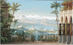
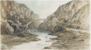
Himalayan region —Kumaon, Garhwal, Nainital (Nainee Tal)

Key Insights

A Rare Early Account of the Central Himalayas The book preserves one of the earliest English-language travel narratives about the Kumaon and Garhwal Himalayas. It offers valuable insight into how these regions appeared before modern tourism, roads, and urban development. 2. Nature as a Spiritual Experience Pilgrim repeatedly portrays the Himalayas as sacred and transformative. Peaks, rivers, and forests are described with reverence rather than merely scientific curiosity. The descriptions of Kedarnath and Badrinath especially reveal the spiritual atmosphere associated with Himalayan pilgrimage routes. 3. Romantic-Era Writing Style The narrative reflects Romantic literary influences similar to writers who viewed nature as emotionally and morally elevating. The scenery is described in elaborate and poetic language, emphasizing sublime beauty and emotional intensity.…

Read the book →

Are you a researcher or reader? If you've found a remarkable insight in any of our documents, share it and we'll feature it here.

Share a Discovery

New Updates

New Updates

New Files Apr. 2026

MAPS Afghanistan– General Maps 1839 Plan and Survey of Bala Hissar fort of Cabul Size: 12M…

6 Apr 2026
New Updates

New Files Oct 2025

  1996 Ganga Singh and P N Sharma Collection of Watercolors at the FRI Dehra…

8 Oct 2025

New to PAHAR?

PAHAR is a free, open-access digital archive of Himalayan literature, maps, and photographs spanning two centuries of exploration and scholarship.

Learn More

PAHAR Network

From pahar.org

Miscellaneous नैनीताल का वो बूढ़ा आदमखोर 17 Jun 2026
Miscellaneous Returning History to the Hills as the Schlagintweit Drawings Reach Dehradun 2 May 2026
Miscellaneous The Closing That Opened New Worlds 29 Apr 2026
Miscellaneous Pundit of Pundits: The Man Who Measured the Himalayas—Step by Step 28 Apr 2026
Miscellaneous Beyond Exploration: The Human Stories Behind the Schlagintweit Drawings 27 Apr 2026

Editor's Pick

Personality James Rennell : A GPS before GPS 17 May 2026
Uncategorized How to Read a Survey of India Map — A Beginner’s Guide to the World’s Greatest Cartographic Project 1 May 2026
New Updates New Files Apr. 2026 6 Apr 2026

New File Lists

29 Jan 2016

Recent New File Additions to the Site: The MCADD collection is a work-in-process and we strive to add a set…

Read more →

Recently Added

Book Search 17 May 2026
Map Indian subcontinent after 1900 6 May 2026 · Indian Subcontinent · 297 files
Map Indian subcontinent pre 1899 6 May 2026 · Indian Subcontinent · 356 files
Journal Central Asian Survey 5 Jun 2024 · Central Asia · 4 files
Journal Royal Asiatic Society China 5 Jun 2024 · 8 files
Map Afghanistan Maps 26 May 2024 · Afghanistan

New documents added every week.

Get the curator's digest — rare finds, new additions, research notes

No spam. Unsubscribe any time.


Partner & Member Archives


👁 Image
Responsible Download Policy No bulk downloading, AI crawlers, or bots. Individual users may download up to 20 files/day without registration. Need more? Contact us for research exports.
WANT UNLIMITED? Register free →