
👁 Image
Municipalities in Utrecht: Amersfoort · Baarn · Bunnik · Bunschoten · De Bilt · De Ronde Venen · Eemnes · Houten · IJsselstein · Leusden · Lopik · Montfoort · Nieuwegein · Oudewater · · Rhenen · Soest · Stichtse Vecht · Utrecht · Utrechtse Heuvelrug · Veenendaal · Vijfheerenlanden · Wijk bij Duurstede · Woerden · Woudenberg · Zeist
-Flag.svg)
Municipalities in Utrecht: Amersfoort · Baarn · Bunnik · Bunschoten · De Bilt · De Ronde Venen · Eemnes · Houten · IJsselstein · Leusden · Lopik · Montfoort · Nieuwegein · Oudewater · · Rhenen · Soest · Stichtse Vecht · Utrecht · Utrechtse Heuvelrug · Veenendaal · Vijfheerenlanden · Wijk bij Duurstede · Woerden · Woudenberg · Zeist
<nowiki>Renswoude; Renswoude; Renswoude; Renswoude; Renswoude; Renswoude; Renswoude; Ռենսվաուդե; 倫斯沃德; Renswoude; Renswoude; Renswoude; Ренсвауде; 倫斯沃德; Renswoude; Renswoude; Renswoude; Renswoude; Renswoude; Renswoude; Ренсвауде; Renswoude; Renswoude; Renswou; Renswoude; Renswoude; Renswoude; Renswoude; Rensvoudė; Renswoude; رنسواده; Gemeente Renswoude; Renswoude; Renswoude; Renswoude; Renswoude; Renswoude; Renswoude; Renswoude; Renswoude; Renswoude; Renswoude; رينسفاوده; Renswoude; Renswoude; Hollanda'da belediye; commune d'Utrecht, Pays-Bas; comune olandese della provincia di Utrecht; hollännesch Gemeng; municipio de los Países Bajos, provincia de Utrecht; Муніципалітет у Нідерландах; gemeente in de provincie Utrecht, Nederland; municipo en Utreĥto, Nederlando; občina na Nizozemskem; Gemeinde in den Niederlanden; համայնք Նիդերլանդներում; municipality in the Netherlands; بلدية في مقاطعة أوترخت، هولندا; conceyu de los Países Baxos; bajarekî Holandayê; Gemeente Renswoude</nowiki>
municipality in the Netherlands | |||||
| Upload media | |||||
| Spoken text audio | Dutchⓘ | ||||
|---|---|---|---|---|---|
| Pronunciation audio | Dutchⓘ | ||||
| Instance of | |||||
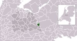
| Location | Utrecht, Netherlands | ||||
| Population |
| ||||
| Area |
| ||||
| Elevation above sea level |
| ||||
| official website | |||||
| 52° 04′ 26.04″ N, 5° 32′ 26.16″ E | |||||
| |||||
| 👁 Edit infobox data on Wikidata | |||||
.svg)
Subcategories
This category has the following 10 subcategories, out of 10 total.
B
- Buildings in Renswoude (7 C, 37 F)
H
- History of Renswoude (1 C, 5 F)
M
- Maps of Renswoude (1 C, 7 F)
N
- Nature of Renswoude (2 C)
P
- People of Renswoude (1 C, 1 F)
R
- Religion in Renswoude (1 C)
S
- Sculptures in Renswoude (1 C, 13 F)
- Symbols of Renswoude (6 F)
T
- Transport in Renswoude (1 C)
- Trekpleister (3 C, 22 F)
Media in category "Renswoude"
The following 20 files are in this category, out of 20 total.
-
14K10 Het Poëziepad.jpg 2,736 × 3,648; 3.56 MB
-
3927 Renswoude, Netherlands - panoramio (40).jpg 4,896 × 3,264; 2.09 MB
-
3927 Renswoude, Netherlands - panoramio (41).jpg 4,896 × 3,264; 2.38 MB
-
3927 Renswoude, Netherlands - panoramio (42).jpg 4,896 × 3,264; 2.34 MB
-
3927 Renswoude, Netherlands - panoramio (43).jpg 4,896 × 3,264; 2.26 MB
-
3927 Renswoude, Netherlands - panoramio.jpg 1,600 × 899; 342 KB
-
Bevolkingspiramide - Gemeente Renswoude (2007).png 350 × 370; 7 KB
-
Emminkhuizerberg.jpg 4,584 × 1,819; 2.52 MB
-
Family Swan at a colourful environment where they built their nest - panoramio.jpg 5,950 × 5,000; 5.64 MB
-
Gardens with lots of flowers besides castle Renswwoude - panoramio.jpg 4,288 × 2,848; 5.63 MB
-
Landgoed Wittenoord (1).jpg 3,024 × 4,032; 9.11 MB
-
Landgoed Wittenoord (2).jpg 4,032 × 3,024; 6.31 MB
-
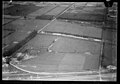
NIMH - 2011 - 0918 - Aerial photograph of Engelaar, The Netherlands - 1920 - 1940.jpg 3,500 × 2,579; 1.64 MB
-
NIMH - 2011 - 2875 - Aerial photograph of Emminkhuizen-Renswoude, The Netherlands.jpg 3,500 × 2,549; 2.09 MB
-
NIMH - 2011 - 2888 - Aerial photograph of Emminkhuizen, Renswoude, The Netherlands.jpg 3,500 × 2,454; 2.05 MB
-
NIMH - 2011 - 3696 - Aerial photograph of Voorwerk Engelaar, The Netherlands.jpg 3,500 × 2,581; 1.64 MB
-
Radio Midland 2022.jpg 1,600 × 1,600; 61 KB
-
Renswoude Lt Rowe Brug.jpg 4,234 × 3,211; 5.24 MB
-
Renswoude, Dorpsstraat, entreeborden met welkom.JPG 3,648 × 2,736; 4.23 MB
.jpg)
.jpg)
.jpg)
.jpg)
.png)
.jpg)
.jpg)