
<nowiki>Wetar; 韋塔島; Wetar; Wetar; Wetar; Востраў Ветар; وتار; 韋塔島; ウェタル島; Pulau Wetar; ווטר; 韋塔島; Pulau Wetar; 韋塔島; Wetar; Ветар; Wetar; Wetar; ওয়েটার; Wetar; Wetar; Wetar; Vetara; Vetaras; Wetar; Wetar; Pulau Wetar; Wetar; Wetar; Wetar; Ветар; Ветар; Pulau Wetar; Wetar; Wetar Island; جزيرة ويتار; Vetaro; جزيره ويتار; île indonésienne; pulo ing Indonésia; illa tropical que pertany a la Província de les Moluques a Indonèsia; größte der Barat-Daya-Inseln (Südwestinseln); ishull; جزيره فى اندونيسيا; ഇന്തോനേഷ്യയുടെ കീഴിലുള്ള ഒരു ദ്വീപ്; острів Індонезії; pulo di Indônésia; インドネシアぬ島; इंडोनेशिया का द्वीप; ostrov v Indonésii; eiland van Indonesië; island in Southwest Maluku Regency, Maluku Province, Indonesia; pulau di Kabupaten Maluku Barat Daya, Maluku; νησί της Ινδονησίας; Isla; Wetar; Wetta; Pulau Wetar; Eiland Wetar; Vetar; Wetar; Wetta; Ветар; Wetar; Pulau Wetar; .വീതിയുമുണ്ട്; Eiland Wetar</nowiki>
island in Southwest Maluku Regency, Maluku Province, Indonesia | |||||
| Upload media | |||||
| Instance of | |||||
|---|---|---|---|---|---|
| Part of | |||||
| Location | Timor and Wetar deciduous forests, Malesia | ||||
| Located in or next to body of water | |||||
| Width |
| ||||
| Length |
| ||||
| Population |
| ||||
| Area |
| ||||
| Elevation above sea level |
| ||||
| Different from | |||||
| 7° 48′ 19″ S, 126° 15′ 58″ E | |||||
| |||||
| 👁 Edit infobox data on Wikidata | |||||
Subcategories
This category has the following 2 subcategories, out of 2 total.
Media in category "Wetar"
The following 10 files are in this category, out of 10 total.
-
Barat Daya Islands de.png 2,271 × 1,557; 1.56 MB
-
Barat Daya Islands en.png 2,271 × 1,557; 1.56 MB
-
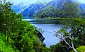
Danau Thiu - Pulau Wetar.jpg 1,024 × 626; 1.17 MB
-
ID Wetar.PNG 670 × 561; 20 KB
-
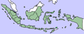
IndonesiaWetar.png 400 × 163; 29 KB
-
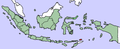
IndonesiaWetar2.png 400 × 163; 29 KB
-
QantasLink Embraer 190 VH-UZH in flight 2023 (04).jpg 6,016 × 4,016; 6.89 MB
-
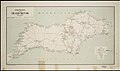
Schetskaart van het Eiland Wetar.jpg 10,643 × 6,272; 11 MB
-
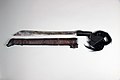
Sword with Scabbard MET 36.25.1398a b 001 Apr2017.jpg 4,000 × 2,667; 2.07 MB
.jpg)