
This article needs additional citations for verification. Please help improve this article by adding citations to reliable sources. Unsourced material may be challenged and removed. Find sources: "A71 road" – news · newspapers · books · scholar · JSTOR (February 2013) (Learn how and when to remove this message) |
| A71 | |||
|---|---|---|---|
| Route information | |||
| Length | 67.7 mi[1] (109.0 km) | ||
| Major junctions | |||
| East end | 👁 Image A70 in Edinburgh 55°56′21″N 3°13′35″W / 55.9392°N 3.2265°W / 55.9392; -3.2265 (A71 road (eastern end)) | ||
| Major intersections | |||
| West end | 👁 Image A737 in Irvine 55°36′25″N 4°39′58″W / 55.6070°N 4.6662°W / 55.6070; -4.6662 (A71 road (western end)) | ||
| Location | |||
| Country | United Kingdom | ||
| Constituent country | Scotland | ||
| Council areas | Edinburgh, West Lothian, North Lanarkshire, South Lanarkshire, East Ayrshire, North Ayrshire | ||
| Primary destinations | Edinburgh, Livingston, Strathaven, Kilmarnock | ||
| Road network | |||
| |||
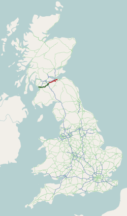
The A71 is a major road in Scotland linking Edinburgh with Lanarkshire and Ayrshire. It adjoins the Livingston Bypass A899.
It runs south west from Edinburgh for approximately 70 miles, through Saughton, Wilkieston and south of Livingston, Whitburn and Wishaw, then by way of Overtown, Garrion Bridge, Stonehouse, Strathaven, Darvel, Newmilns, Galston, Hurlford and Kilmarnock to Irvine on the North Ayrshire coast.
Formerly a trunk route from the east to the west coast of Scotland it has since been downgraded to a mix of primary and secondary routes. From Edinburgh to Darvel, it is now a secondary route, in a poor state of repair in some places. But, from Darvel to Irvine, it has retained its primary route status.
Route
[edit]Edinburgh to Newmains
[edit]The A71 almost parallels the M8 between the A720 (Edinburgh City Bypass) and the junction with the A73 at Newmains. It passes through the village of Wilkieston and onto the Mid Calder bypass, which leads the route to the south of Livingston. The A71 follows a very straight course through Livingston with several grade separated junctions.
Newmains to Darvel
[edit]
West of Livingston, the A71 turns sharply south west, bypassing Shotts, Newmains and Wishaw then descends steeply into the Clyde Valley, over Garrion Bridge at the junction with the A72. The A71 climbs steeply up the western side of the Clyde valley on a road which it shares for a very short section with the A72.
When the A71 peaks at the top of the valley, it goes under the M74 at Jct 8 (a junction known locally as Canderside Toll), before turning towards the village of Stonehouse, where a bypass takes traffic to the north of the narrow village roads, before descending into the Avon valley and into Strathaven. This small town, at a meeting of the A71, A723 and A726, provides a link to East Kilbride and Paisley, as well as to Lanark, Hamilton and Motherwell.
Darvel to Irvine
[edit]The A71 then becomes a narrow and winding road across moorland, as the road ascends to the head of the Avon valley. At the highest point is Loudoun Hill, an ancient site of human occupation, and the road here follows the route of a minor Roman road which once linked the Clyde Valley and the coast. The road descends into the Irvine Valley, going through the towns of Darvel and Newmilns, and bypassing Galston and then through Hurlford. At Darvel, the A71 becomes a primary route for the rest of its length to Irvine, and widens slightly, with a straighter alignment until its junction with the A77, south of Kilmarnock. The A71 remains as a dual-carriageway until its terminus in Irvine town centre. A crash barrier runs along the central reservation of the dual-carriageway from the A77 to the boundary with North Ayrshire at Dreghorn.
In mid 2014, the road began to subside between Darvel and Newmilns, with the westbound lane being affected near to the entrance to Gowanbank House. Traffic lights were put in place while a solution was sought, however as of January 2017, a solution has been found and the traffic lights have been lifted.
Junction list
[edit]| Council area | Location | mi[1] | km | Destinations | Notes |
|---|---|---|---|---|---|
| Edinburgh | Edinburgh | 0.0 | 0.0 | Dalry Road (A70) / Murieston Road / Henderson Terrace | Eastern terminus; no access from A71 to A70 south or from A70 north to A71 |
| Edinburgh– Currie boundary | 3.4– 3.5 | 5.5– 5.6 | 👁 Image 👁 Image 👁 Image 👁 Image 👁 Image 👁 Image 👁 Image A720 / M8 / M9 / A1 / A8 / A90 – Edinburgh (S, E & N), Berwick upon Tweed, Glasgow, Forth Road Bridge, Stirling, Livingston | Junction on A720 | |
| West Lothian | Livingston– Mid Calder boundary | 11.7 | 18.8 | 👁 Image 👁 Image 👁 Image 👁 Image A899 north / B8046 (Calder Park Road) to M8 / A89 – Glasgow, Edinburgh, Mid Calder, Bathgate, Broxburn | To A89, Bathgate and Broxburn signed eastbound only; southern terminus of A899 |
| Livingston | 12.1 | 19.5 | Dedridge, Murieston | Junction | |
| 12.3– 12.6 | 19.8– 20.3 | Dedridge, Murieston | Junction | ||
| West Calder | 16.4 | 26.4 | 👁 Image 👁 Image A704 southwest to A706 – Lanark | Northeastern terminus of A704 | |
| 19.7 | 31.7 | 👁 Image A706 – Lanark, Linlithgow | |||
| North Lanarkshire | Newmains | 29.0 | 46.7 | 👁 Image 👁 Image 👁 Image A73 north (Westwood Road) / A722 west (Manse Road) / Bonkle Road to M8 – Airdrie, Wishaw, Bonkle, Edinburgh, Glasgow | To M8, Edinburgh and Glasgow signed eastbound only; eastern terminus of A73 concurrency; eastern terminus of A722 |
| 29.5 | 47.5 | 👁 Image 👁 Image A73 south (Main Street) to A721 – Peebles, Lanark, Carluke | Western terminus of A73 concurrency | ||
| Waterloo | 30.7 | 49.4 | 👁 Image 👁 Image A721 (Wishaw Road) to A73 – Lanark, Carluke, Wishaw | ||
| North Lanarkshire– South Lanarkshire boundary | Garrion Bridge | 32.8 | 52.8 | 👁 Image A72 east – Lanark | Eastern terminus of A72 concurrency |
| South Lanarkshire | 33.3 | 53.6 | 👁 Image 👁 Image A72 west to M74 north – Hamilton, Glasgow | Western terminus of A72 | |
| | 35.5– 35.7 | 57.1– 57.5 | 👁 Image 👁 Image M74 to A74 – Carlisle, Glasgow | Some access via roundabout with B7078; M74 junction | |
| Strathaven | 41.1 | 66.1 | Bridge Street (A726 northwest) / Castle Street | Southeastern terminus of A726 | |
| 41.5 | 66.8 | 👁 Image 👁 Image A723 northeast to A726 – Hamilton, East Kilbride | Southwestern terminus of A723 | ||
| East Ayrshire | Galston | 56.0 | 90.1 | 👁 Image 👁 Image 👁 Image A719 to A76 / A77 / B7037 – Kilmarnock, Ayr, Glasgow, Galston, Sorn, Waterside, Moscow | To A76 and Kilmarnock signed westbound only, To B7037 and Ayr eastbound only |
| Kilmarnock– Riccarton boundary | 59.8– 60.0 | 96.2– 96.6 | 👁 Image 👁 Image 👁 Image 👁 Image M77 northeast / A77 / A76 south / A735 north (Queen's Drive) to B778 – Glasgow, Ayr, Prestwick Airport, Dumfries, Kilmarnock, Mauchline, Auchinleck, Cumnock, Riccarton, Fenwick | Mauchline, Auchinleck and Cumnock signed westbound only, To B778, Riccarton and Fenwick eastbound only; southwestern terminus of M77; northern terminus of A76; southern terminus of A735 | |
| Riccarton | 61.0 | 98.2 | B7038 – Kilmarnock | Junction; eastbound exit and westbound entrance | |
| North Ayrshire | Dreghorn– Irvine boundary | 66.2– 66.6 | 106.5– 107.2 | Riverside, Meadowhead | Junction; Meadowhead signed westbound only |
| Irvine | 66.9– 67.0 | 107.7– 107.8 | 👁 Image A78 to B746 – Troon, Prestwick Airport, Ayr, Kilwinning, Ardrossan, Greenock, Largs | To B746, Troon and Kilwinning signed westbound only, Largs eastbound only; junction on A78 | |
| 67.7 | 109.0 | 👁 Image 👁 Image A737 (Ayr Road) / Riverway to A78 – Ayr, Kilwinning | Western terminus | ||
1.000 mi = 1.609 km; 1.000 km = 0.621 mi
| |||||
References
[edit]- ^ a b "55.9392347, -3.2262714 to 435 Calder Rd, Edinburgh EH11 4AN, UK to 11 Rubie Cres, Irvine KA12 8HA, UK". Google Maps. Retrieved 16 December 2025.
External links
[edit]- 👁 Wikimedia Commons logo
Media related to A71 road (Scotland) at Wikimedia Commons
Download coordinates as:
55°44′15″N 3°56′23″W / 55.7376°N 3.9396°W / 55.7376; -3.9396 (A71 road)
- Roads in Scotland
- Transport in Edinburgh
- Transport in North Ayrshire
- Transport in East Ayrshire
- Transport in West Lothian
- Transport in North Lanarkshire
- Transport in South Lanarkshire
- Strathaven
- Irvine, North Ayrshire
- Kilmarnock
- Galston, East Ayrshire
- Darvel
- Stonehouse, South Lanarkshire
- Livingston, West Lothian
- Gorgie
- West Calder
- Pages using gadget WikiMiniAtlas
- Articles with short description
- Short description matches Wikidata
- Articles needing additional references from February 2013
- All articles needing additional references
- Use dmy dates from January 2024
- Use British English from February 2013
- All Wikipedia articles written in British English
- Infobox road instances in Scotland
- Commons category link from Wikidata
- Lists of coordinates
- Geographic coordinate lists
- Articles with Geo
- Coordinates on Wikidata