
This article needs additional citations for verification. Please help improve this article by adding citations to reliable sources. Unsourced material may be challenged and removed. Find sources: "Dabeiba" – news · newspapers · books · scholar · JSTOR (March 2020) (Learn how and when to remove this message) |
Dabeiba | |
|---|---|
Municipality and town | |
| 👁 Bold t§ext Bold t§ext | |
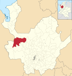
| 👁 Location of the municipality and town of Dabeiba in the Antioquia Department of Colombia Location of the municipality and town of Dabeiba in the Antioquia Department of Colombia | |
Location in Colombia | |
| Coordinates: 7°0′5″N 76°15′40″W / 7.00139°N 76.26111°W / 7.00139; -76.26111 | |
| Country | 👁 Image Colombia |
| Department | 👁 Image Antioquia Department |
| Subregion | Western |
| Area | |
• Total | 1,883 km2 (727 sq mi) |
| Elevation | 450 m (1,480 ft) |
| Population (Census 2018[1]) | |
• Total | 22,717 |
| • Density | 12.06/km2 (31.25/sq mi) |
| Time zone | UTC-5 (Colombia Standard Time) |
.svg)
Dabeiba (Spanish pronunciation: [daˈβejβa]) is a town and municipality in the Colombian department of Antioquia. The population was 22,717 at the 2018 census. The Battle of Dabeiba took place there in October 2000.[2]
Climate
[edit]Dabeiba has a tropical rainforest climate (Köppen Af) with very heavy rainfall most of the year and a drier season from January to March, when there is still between 90 and 110 millimetres (3.5 and 4.3 in) of rain. The climate is markedly less extreme than the core of the Chocó to its south, receiving less than half the rainfall of such towns as Andagoya, Quibdó or Buenaventura.
| Climate data for Dabeiba | |||||||||||||
|---|---|---|---|---|---|---|---|---|---|---|---|---|---|
| Month | Jan | Feb | Mar | Apr | May | Jun | Jul | Aug | Sep | Oct | Nov | Dec | Year |
| Mean daily maximum °C (°F) | 31.5 (88.7) |
31.6 (88.9) |
32.1 (89.8) |
31.5 (88.7) |
30.4 (86.7) |
30.6 (87.1) |
30.7 (87.3) |
30.7 (87.3) |
29.9 (85.8) |
29.8 (85.6) |
29.8 (85.6) |
30.3 (86.5) |
30.7 (87.3) |
| Daily mean °C (°F) | 25.7 (78.3) |
26.1 (79.0) |
26.6 (79.9) |
26.1 (79.0) |
25.6 (78.1) |
25.6 (78.1) |
25.6 (78.1) |
25.7 (78.3) |
25.2 (77.4) |
25.1 (77.2) |
25.1 (77.2) |
25.3 (77.5) |
25.6 (78.2) |
| Mean daily minimum °C (°F) | 20.0 (68.0) |
20.6 (69.1) |
21.1 (70.0) |
20.8 (69.4) |
20.8 (69.4) |
20.6 (69.1) |
20.6 (69.1) |
20.7 (69.3) |
20.6 (69.1) |
20.5 (68.9) |
20.5 (68.9) |
20.4 (68.7) |
20.6 (69.1) |
| Average rainfall mm (inches) | 95 (3.7) |
91 (3.6) |
108 (4.3) |
274 (10.8) |
342 (13.5) |
331 (13.0) |
319 (12.6) |
359 (14.1) |
349 (13.7) |
385 (15.2) |
299 (11.8) |
209 (8.2) |
3,161 (124.5) |
| Source: Climate-Data.org[3] | |||||||||||||
References
[edit]- ^ "Censo Nacional de Población y Vivienda 2018" (in Spanish). Retrieved 23 April 2020.
- ^ Dozens die in Colombia battle
- ^ "Climate: Dabeiba". Climate-Data.org. Retrieved August 30, 2020.
Retrieved from "https://en.wikipedia.org/w/index.php?title=Dabeiba&oldid=1330439031"
Hidden categories: