
Eisacktal | |
|---|---|
| Comunità comprensoriale Valle Isarco Bezirksgemeinschaft Eisacktal | |
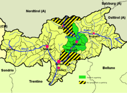
| 👁 Eisacktal (highlighted in green) within South Tyrol; the yellow-black stripes mark the geographical extent of the valley Eisacktal (highlighted in green) within South Tyrol; the yellow-black stripes mark the geographical extent of the valley | |
| Country | 👁 Image Italy |
| Autonomous region | 👁 Image Trentino-Alto Adige |
| Autonomous province | 👁 Image South Tyrol |
| Established | 1968 |
| Administrative seat | Brixen (Bressanone) |
| Area | |
• Total | 624 km2 (241 sq mi) |
| Population (2005) | |
• Total | 47,492 |
| • Density | 76.1/km2 (197/sq mi) |
| Website | www.bzgeisacktal.it |
.png)
Eisack Valley (Italian: Valle Isarco [ˈvalleiˈzarko]; German: Eisacktal) is a district (Italian: comprensorio; German: Bezirksgemeinschaft) in South Tyrol, Italy. It comprises the middle part of the valley of the Eisack, from Franzensfeste in the north to Waidbruck in the south.
Overview
[edit].jpg)
The valley of the Eisack river stretches from Brenner Pass southwards down to its confluence with the Adige near Bolzano. The upper valley north of Franzensfeste is known as Wipptal, while the lower parts belong to the Salten-Schlern administrative district. The valley is part of a major transport route across the eastern Alps, traversed by the Autostrada A22 (part of the European route E45) and the parallel Brenner Railway line.
According to the 2001 census, 85.76% of the population of the valley speak German, 13.22% Italian and 1.02% Ladin as first language.[1]
Subdivision
[edit]The following municipalities are part of the Eisacktal district:
- Barbian
- Brixen (district capital)
- Feldthurns
- Klausen
- Lajen
- Lüsen
- Mühlbach
- Natz-Schabs
- Rodeneck
- Vahrn
- Villanders
- Villnöß
- Waidbruck
References
[edit]- ^ Bevölkerung und soziales Leben, Statistisches Jahrbuch 2006, p. 120, tab. 3.19
External links
[edit]
- Eisacktal District (in German and Italian)
- Valle Isarco Panorama WebCam Archived 2024-02-28 at the Wayback Machine
- Pages using gadget WikiMiniAtlas
- Articles with short description
- Short description is different from Wikidata
- Pages using infobox settlement with no coordinates
- Articles containing Italian-language text
- Pages with Italian IPA
- Articles containing German-language text
- Commons category link is on Wikidata
- Articles with German-language sources (de)
- Articles with Italian-language sources (it)
- Webarchive template wayback links
- Coordinates on Wikidata