
You can help expand this article with text translated from the corresponding article in German. (December 2009) Click [show] for important translation instructions.
|
Elsterwerda | |
|---|---|
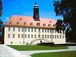
| 👁 Château Château | |
|
👁 Coat of arms of Elsterwerda Coat of arms | |
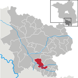
Location of Elsterwerda
within Elbe-Elster district | |
Location of Elsterwerda | |
| Coordinates: 51°27′28″N 13°31′26″E / 51.45778°N 13.52389°E / 51.45778; 13.52389 | |
| Country | Germany |
| State | Brandenburg |
| District | Elbe-Elster |
| Subdivisions | Town centre and 2 districts |
| Government | |
| • Mayor (2017–25) | Anja Heinrich[1] (CDU) |
| Area | |
• Total | 40.58 km2 (15.67 sq mi) |
| Elevation | 90 m (300 ft) |
| Population (2024-12-31)[2] | |
• Total | 7,663 |
| • Density | 188.8/km2 (489.1/sq mi) |
| Time zone | UTC+01:00 (CET) |
| • Summer (DST) | UTC+02:00 (CEST) |
| Postal codes | 04910 |
| Dialling codes | 03533 |
| Vehicle registration | EE, FI, LIB |
| Website | www.elsterwerda.de |
Elsterwerda (German pronunciation: [ˌɛlstɐˈvɛʁda] ⓘ; Lower Sorbian: Wikow) is a town in the Elbe-Elster district, in southwestern Brandenburg, Germany. It is situated on the Black Elster river, 48 km northwest of Dresden, and 11 km southeast of Bad Liebenwerda.
History
[edit]From 1952 to 1990, Elsterwerda was part of the Bezirk Cottbus of East Germany.
Demography
[edit]-
👁 Development of Population since 1875 within the Current Boundaries (Blue Line: Population; Dotted Line: Comparison to Population Development of Brandenburg state; Grey Background: Time of Nazi rule; Red Background: Time of Communist rule)Development of Population since 1875 within the Current Boundaries (Blue Line: Population; Dotted Line: Comparison to Population Development of Brandenburg state; Grey Background: Time of Nazi rule; Red Background: Time of Communist rule)
-
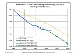
👁 Recent Population Development and Projections (Population Development before Census 2011 (blue line); Recent Population Development according to the Census in Germany in 2011 (blue bordered line); Official projections for 2005-2030 (yellow line); for 2020-2030 (green line); for 2017-2030 (scarlet line)Recent Population Development and Projections (Population Development before Census 2011 (blue line); Recent Population Development according to the Census in Germany in 2011 (blue bordered line); Official projections for 2005-2030 (yellow line); for 2020-2030 (green line); for 2017-2030 (scarlet line)
Elsterwerda: Population development within the current boundaries (2017)[3] | |||||||||||||||||||||||||||||||||||||||||||||||||||||||||||||||||||||||||||||||||||||||||||||||||||||||||||||||||||||||||||||||||||||||||||||||
|
|
| |||||||||||||||||||||||||||||||||||||||||||||||||||||||||||||||||||||||||||||||||||||||||||||||||||||||||||||||||||||||||||||||||||||||||||||
Gallery
[edit]-
City
-
Church „St. Katharina“
-
City hall
-
Miniature park
-
Windmill
-
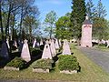
War memorial
-
Water tower
-
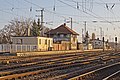
Railway station
-
Maria Josepha of Austria, Queen of Poland
Notable people
[edit]
- Maria Josepha of Austria (1699–1757), Austrian princess and Queen of Poland
- Hartmut Buschbacher (born 1958), international rowing coach
- Charles of Saxony, Duke of Courland (1733–1796), Saxon prince
- Franciszka Krasińska (1742–1796), Polish noblewoman and morganatic wife of the above
- Johann Gottlob Theaenus Schneider (1750–1822), classicist and naturalist, spent his childhood in Elsterwerda
- Johannes Gillhoff (1861–1930), teacher and author
- Erich Straube (1887–1971), officer in WW I and WW II
- Richard Markert (1891–1957), senate president and mayor of Bremen
- Bernd Martin (born 1940), historian, grew up in Elsterwerda
- Siegbert Horn (1950–2016), canoeist, Olympic and World Champion
- Ralf Minge (born 1960), football player and coach
See also
[edit]References
[edit]- ^ Landkreis Elbe-Elster Wahl der Bürgermeisterin / des Bürgermeisters, accessed 1 July 2021.
- ^ "Bevölkerungsstand im Land Brandenburg Dezember 2024 (Fortgeschriebene amtliche Einwohnerzahlen, basierend auf dem Zensus 2023)" (XLS). Amt für Statistik Berlin-Brandenburg (in German).
- ^ Detailed data sources are to be found in the Wikimedia Commons.Population Projection Brandenburg at Wikimedia Commons
External links
[edit]- Official website (in German)
Hidden categories:
- Pages using gadget WikiMiniAtlas
- Pages using the Phonos extension
- CS1 German-language sources (de)
- Featured articles needing translation from German Wikipedia
- Geography articles needing translation from German Wikipedia
- Articles with short description
- Short description is different from Wikidata
- Coordinates on Wikidata
- Pages using infobox settlement with potentially too many maps
- Pages with German IPA
- Pages including recorded pronunciations
- Articles containing Lower Sorbian-language text
- Official website different in Wikidata and Wikipedia
- Articles with German-language sources (de)
- All stub articles
- Pages using the Kartographer extension