
Fara in Sabina | |
|---|---|
| Comune di Fara in Sabina | |
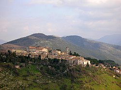
| 👁 Panoramic view Panoramic view | |
|
👁 Coat of arms of Fara in Sabina Coat of arms | |
| 👁 Fara in Sabina within the Province of Rieti Fara in Sabina within the Province of Rieti | |
👁 Fara in Sabina is located in Italy Fara in Sabina Location of Fara in Sabina in Italy 👁 Fara in Sabina is located in Lazio Fara in Sabina Fara in Sabina (Lazio) | |
| Coordinates: 42°13′N 12°44′E / 42.217°N 12.733°E / 42.217; 12.733 | |
| Country | Italy |
| Region | Lazio |
| Province | Rieti (RI) |
| Frazioni | Baccelli, Borgo Quinzio, Canneto Sabino, Coltodino, Corese Terra, Farfa, Passo Corese, Prime Case, Talocci |
| Government | |
| • Mayor | Roberta Cuneo |
| Area | |
• Total | 55 km2 (21 sq mi) |
| Elevation | 482 m (1,581 ft) |
| Population | |
• Total | 13,904 |
| • Density | 250/km2 (650/sq mi) |
| Demonym | Faresi |
| Time zone | UTC+1 (CET) |
| • Summer (DST) | UTC+2 (CEST) |
| Postal code | 02032 |
| Dialing code | 0765 |
| Patron saint | St. Antoninus |
| Saint day | 2 September |
| Website | Official website |
.svg)
Fara in Sabina (also shortened to Fara Sabina) is a comune (municipality) in the Province of Rieti in the Italian region of Lazio, located about 40 kilometres (25 mi) northeast of Rome and about 25 kilometres (16 mi) southwest of Rieti.
History
[edit]The area was inhabited in prehistoric times, as attested by several archaeological findings from the mid-Palaeolithic and late Bronze Ages.
Between the 9th and the 6th centuries BC, a settlement of the Sabines, identified with the city of Cures, existed here, continuing into Roman Empire times. Remains from it include the baths, a small theatre and terraces for agriculture.
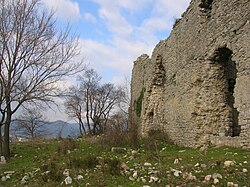
The origins of the modern town date from Lombard times (late 6th century AD), as it has been supposed from the presence of the Lombard word fara ("family clan") in the name. A castle is known from 1006 and, from 1050, Fara was a possession of the Abbey of Farfa, which is located in the present municipal territory. Later it was a fief of the Orsini.
During World War II, the POW camp P.G. 54 was located at adjacent Passo Corese.[4]
The main Roman Catholic church is the Duomo Collegiata di Sant'Antonio Martire.
Geography
[edit]The municipality borders with Castelnuovo di Farfa, Montelibretti, Montopoli di Sabina, Nerola and Toffia.[5]
It counts the hamlets of Baccelli, Borgo Quinzio, Canneto Sabino, Coltodino, Corese Terra, Farfa, Passo Corese, Prime Case and Talocci.
International relations
[edit]Fara in Sabina is twinned with:
- 👁 Italy
Montelupo Fiorentino, Italy - 👁 Italy
Santa Vittoria in Matenano, Italy - 👁 France
Villemur-sur-Tarn, France
References
[edit]- ^ "Superficie di Comuni Province e Regioni italiane al 9 ottobre 2011". Italian National Institute of Statistics. Retrieved 16 March 2019.
- ^ "Popolazione Residente al 1° Gennaio 2018". Italian National Institute of Statistics. Retrieved 16 March 2019.
- ^ All demographics and other statistics: Italian statistical institute Istat.
- ^ World War II - PoW Escape Routes in Italy 1943/44 Archived 2012-01-31 at the Wayback Machine P.4
- ^ 41835 (x j a h) Fara in Sabina on OpenStreetMap
External links
[edit]- 👁 Wikimedia Commons logo
Media related to Fara in Sabina at Wikimedia Commons - Official website (in Italian)
- Webarchive template wayback links
- Articles with short description
- Short description is different from Wikidata
- Articles containing Italian-language text
- Pages using gadget WikiMiniAtlas
- Official website different in Wikidata and Wikipedia
- Commons category link is on Wikidata
- Articles with Italian-language sources (it)
- All stub articles