
Ontsudd.png (378 × 379 pixels, file size: 10 KB, MIME type: image/png)
This is a file from the Wikimedia Commons. Information from its description page there is shown below.
Commons is a freely licensed media file repository. You can help.
Commons is a freely licensed media file repository. You can help.
Summary
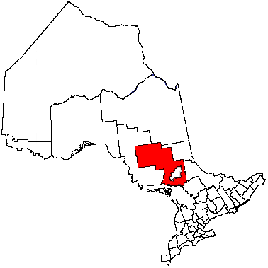
| Description | Sudbury District, Ontario. This is the same subdivision map of Ontario already posted to several other related articles by en:User:Earl Andrew; I've simply edited the image to reflect a district not yet mapped. |
| Date | 7 March 2004 (original upload date) |
| Source | Transferred from en.wikipedia to Commons. |
| Author | The original uploader was Bearcat at English Wikipedia. |
Licensing
| 👁 GNU head |
Permission is granted to copy, distribute and/or modify this document under the terms of the GNU Free Documentation License, Version 1.2 or any later version published by the Free Software Foundation; with no Invariant Sections, no Front-Cover Texts, and no Back-Cover Texts. A copy of the license is included in the section entitled GNU Free Documentation License. |
| 👁 w:en:Creative Commons 👁 attribution 👁 share alike |
This file is licensed under the Creative Commons Attribution-Share Alike 3.0 Unported license. |
| |
| This licensing tag was added to this file as part of the GFDL licensing update. |
Original upload log
The original description page was here. All following user names refer to en.wikipedia.
- 2004-03-07 03:11 Bearcat 378×379×8 (9898 bytes) This is the same subdivision map of Ontario already posted to several other related articles by [[User:Earl Andrew]]; I've simply edited the image to reflect a district not yet mapped.
File history
Click on a date/time to view the file as it appeared at that time.
| Date/Time | Thumbnail | Dimensions | User | Comment | |
|---|---|---|---|---|---|
| current | 21:02, 26 November 2006 | 👁 Thumbnail for version as of 21:02, 26 November 2006 | 378 × 379 (10 KB) | Hopperseven | {{Information |Description=This is the same subdivision map of Ontario already posted to several other related articles by en:User:Earl Andrew; I've simply edited the image to reflect a district not yet mapped. |Source=Originally from [http://en.wiki |
File usage
The following 33 pages use this file:
- Atikameksheng Anishnawbek First Nation
- Baldwin, Ontario
- Brunswick House First Nation
- Cartier, Ontario
- Chapleau, Ontario
- Chapleau 61
- Chapleau 61A
- Chapleau 74
- Chapleau 74A
- Chapleau 75
- Chapleau Cree Fox Lake
- Duck Lake 76B
- Espanola, Ontario
- Foleyet
- French River, Ontario
- Gogama
- Killarney, Ontario
- Markstay-Warren
- Mattagami First Nation
- Michipicoten First Nation
- Missanabie Cree First Nation
- Mountbatten 76A
- Nairn and Hyman
- Point Grondine Park
- Rainbow Country
- Sables-Spanish Rivers
- St. Charles, Ontario
- Sudbury District
- Unorganized North Sudbury District
- Whitefish Lake 6, Ontario
- Wiikwemkoong First Nation
- User:Julius177/nairn
- Template:Sudbury District
Global file usage
The following other wikis use this file:
- Usage on ja.wikipedia.org
Retrieved from "https://en.wikipedia.org/wiki/File:Ontsudd.png"