
Gandino | |
|---|---|
| Comune di Gandino | |
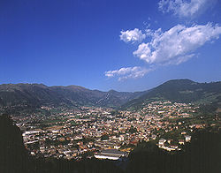
| 👁 Gandino Gandino | |
Location of Gandino in Italy Gandino (Lombardy) | |
| Coordinates: 45°49′N 9°54′E / 45.817°N 9.900°E / 45.817; 9.900 | |
| Country | Italy |
| Region | Lombardy |
| Province | Bergamo (BG) |
| Frazioni | Barzizza, Cirano |
| Area | |
• Total | 29.1 km2 (11.2 sq mi) |
| Elevation | 553 m (1,814 ft) |
| Population (30 April 2017)[2] | |
• Total | 5,423 |
| • Density | 186/km2 (483/sq mi) |
| Demonym | Gandinesi |
| Time zone | UTC+1 (CET) |
| • Summer (DST) | UTC+2 (CEST) |
| Postal code | 24024 |
| Dialing code | 035 |
| Website | Official website |
Gandino (Bergamasque: Gandì) is a comune (municipality) in the Province of Bergamo in the Italian region of Lombardy, located about 70 kilometres (43 mi) northeast of Milan and about 20 kilometres (12 mi) northeast of Bergamo.
Gandino borders the following municipalities: Casnigo, Cazzano Sant'Andrea, Cerete, Clusone, Endine Gaiano, Leffe, Peia, Ponte Nossa, Ranzanico, Rovetta, Sovere.
Notable people
[edit]- Lorenzo Frana, Vatican diplomat, museum founder
See also
[edit]References
[edit]- ^ "Superficie di Comuni Province e Regioni italiane al 9 ottobre 2011". Italian National Institute of Statistics. Retrieved 16 March 2019.
- ^ All demographics and other statistics: Italian statistical institute Istat.
External links
[edit]
Wikimedia Commons has media related to Gandino.
Retrieved from "https://en.wikipedia.org/w/index.php?title=Gandino&oldid=1292647375"
Hidden categories:
- Pages using gadget WikiMiniAtlas
- Articles with short description
- Short description is different from Wikidata
- Articles containing Italian-language text
- Coordinates on Wikidata
- Official website different in Wikidata and Wikipedia
- Articles containing Lombard-language text
- Commons link from Wikidata
- All stub articles