
Garray | |
|---|---|
| 👁 Image | |
|
👁 Flag of Garray Flag 👁 Coat of arms of Garray Coat of arms | |
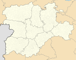
| 👁 Garray within the province of Soria Garray within the province of Soria | |
Location in Spain. Garray (Spain) | |
| Coordinates: 41°48′52″N 2°26′52″W / 41.81444°N 2.44778°W / 41.81444; -2.44778 | |
| Country | Spain |
| Autonomous community | 👁 Image Castile and León |
| Province | 👁 Image Soria |
| Municipality | Garray |
| Government | |
| • Mayoress | María José Jiménez Las Heras |
| Area | |
• Total | 76.24 km2 (29.44 sq mi) |
| Elevation | 1.011 m (3.32 ft) |
| Population (2025-01-01)[1] | |
• Total | 794 |
| Time zone | UTC+1 (CET) |
| • Summer (DST) | UTC+2 (CEST) |
| Website | Official website 👁 Edit this at Wikidata |
_Mapa.svg)
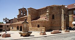
Garray is a municipality located in the province of Soria, Castile and León, Spain.
History
[edit]The archaeological site of Numantia is within the boundaries of Garray. It is famous for its role in the Celtiberian Wars.
References
[edit]- ^ National Statistics Institute (13 December 2025). "Municipal Register of Spain of 2025".
2. Garray#cite ref-2 Municipal Register of Spain 2022. Instituto Nacional de Estadística (Spain)
Retrieved from "https://en.wikipedia.org/w/index.php?title=Garray&oldid=1312306648"