
Haflong
The White Ant Hills Town | |
|---|---|
Town | |
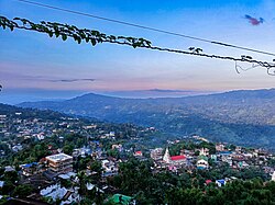
| 👁 A bird's eye view of Haflong town from Synod view point (altitude: 593 mt amsl approx). A bird's eye view of Haflong town from Synod view point (altitude: 593 mt amsl approx). | |
| Coordinates: 25°10′08″N 93°00′58″E / 25.169°N 93.016°E / 25.169; 93.016 | |
| Country | 👁 Image India |
| State | Assam |
| District | Dima Hasao |
| Government | |
| • Body | Haflong Municipal Board |
| Area | |
• Total | 12.79 km2 (4.94 sq mi) |
| Elevation | 966.216 m (3,170.00 ft) |
| Population (2011)[1] | |
• Total | 43,756 |
| • Density | 3,421/km2 (8,861/sq mi) |
| Languages | |
| • Lingua franca | Haflong Hindi[2] |
| • Most common | Bengali, Dimasa[2] |
| Time zone | UTC+5:30 (IST) |
| PIN | 788819 & 788820 |
| Telephone code | 03673 |
| ISO 3166 code | IN-AS |
| Vehicle registration | AS 08-X XXXX |
Haflong is a town and the headquarters of the Dima Hasao district (formerly North Cachar Hills) of the northeast Indian state of Assam. It is the only hill station in the state.[3]
Etymology
[edit]Haflong is a Dimasa word meaning ant hill.[4]
Geography
[edit]Haflong has a subtropical highland climate (Köppen climate classification Cwb), falling just short of a tropical savanna climate (Köppen climate classification Aw). In May 2022, Haflong witnessed torrential rainfall, recording the highest rainfall, up to 451 mm on 14 May 2022, as compared to the maximum 190 mm to 200 mm reported annually.[5]
| Climate data for Haflong | |||||||||||||
|---|---|---|---|---|---|---|---|---|---|---|---|---|---|
| Month | Jan | Feb | Mar | Apr | May | Jun | Jul | Aug | Sep | Oct | Nov | Dec | Year |
| Record high °C (°F) | 28.8 (83.8) |
25.2 (77.4) |
28.4 (83.1) |
29.0 (84.2) |
20.0 (68.0) |
28.3 (82.9) |
26.5 (79.7) |
28.2 (82.8) |
25.8 (78.4) |
24.3 (75.7) |
26.0 (78.8) |
18.1 (64.6) |
29.0 (84.2) |
| Mean daily maximum °C (°F) | 19.6 (67.3) |
20.2 (68.4) |
21.0 (69.8) |
22.2 (72.0) |
22.2 (72.0) |
25.7 (78.3) |
24.9 (76.8) |
23.2 (73.8) |
22.7 (72.9) |
22.3 (72.1) |
21.6 (70.9) |
20.7 (69.3) |
22.2 (72.0) |
| Mean daily minimum °C (°F) | 8.3 (46.9) |
12.0 (53.6) |
15.9 (60.6) |
20.0 (68.0) |
22.7 (72.9) |
20.9 (69.6) |
20.6 (69.1) |
20.6 (69.1) |
21.7 (71.1) |
21.9 (71.4) |
16.7 (62.1) |
11.8 (53.2) |
17.8 (64.0) |
| Record low °C (°F) | 3.7 (38.7) |
4.1 (39.4) |
6.3 (43.3) |
12.0 (53.6) |
13.2 (55.8) |
15.4 (59.7) |
18.4 (65.1) |
18.1 (64.6) |
15.7 (60.3) |
10.6 (51.1) |
8.3 (46.9) |
5.0 (41.0) |
3.7 (38.7) |
| Average rainfall mm (inches) | 11.9 (0.47) |
18.3 (0.72) |
55.8 (2.20) |
147.9 (5.82) |
244.2 (9.61) |
316.4 (12.46) |
345.4 (13.60) |
264.3 (10.41) |
185.9 (7.32) |
91.2 (3.59) |
18.7 (0.74) |
7.1 (0.28) |
1,707.1 (67.22) |
| Average rainy days | 1.8 | 2.9 | 5.8 | 13.1 | 17.0 | 19.6 | 22.3 | 18.5 | 15.2 | 7.4 | 2.8 | 1.3 | 127.7 |
| Average relative humidity (%) | 69 | 55 | 47 | 48 | 55 | 51 | 53 | 52 | 53 | 52 | 52 | 52 | 53 |
| Mean monthly sunshine hours | 106.3 | 174.7 | 180.1 | 181.0 | 152.2 | 102.0 | 104.0 | 121.2 | 98.0 | 104.6 | 131.0 | 132.5 | 1,587.6 |
| Source 1: World Meteorological Organization.[6] NOAA (extremes & humidity, 1971–1990)[7] | |||||||||||||
| Source 2: Hong Kong Observatory.[8] | |||||||||||||
Demographics
[edit]Population
[edit]As of 2011, India census, Haflong has a population of 43,756. Males constitute 45% of the population and females 55%. Haflong has an average literacy rate of 92%, higher than the national average of 59.5%: male literacy is 85%, and female literacy is 75%. In Haflong, 12% of the population is under 6 years of age. As of 2011[update], Haflong town has a population of 43,756.[1]
Languages
[edit]Bengali is the most spoken language of the town with a population of 9,710, followed by Dimasa (7,855).[9][2] Haflong Hindi is the lingua franca of the town.[2] Other languages with significant population include Hmar (4,921), Zemi (3,426), Kuki (3,027), Hindi (2,781) and Assamese (1,236).[9]
Government and politics
[edit]Haflong is part of Autonomous District (Lok Sabha constituency). It is the headquarter of Dima Hasao Autonomous Council.[12]
Tourism
[edit]Haflong is a popular destination for travellers seeking a quieter alternative to larger hill stations.
Key attractions include:
- Haflong Lake – a scenic lake in the heart of the town
- Jatinga – known for the phenomenon of bird behaviour (often described as bird “mystery”)
- Maibang – historical site with ruins linked to the Dimasa kingdom
Trekking and nature walks are also popular in the surrounding hills.
- ^ a b "Haflong City Population Census 2011 - Assam". www.census2011.co.in.
- ^ a b c d Col. Ved Prakash (2007). Encyclopaedia of North-East India. Atlantic Publishers & Dist. pp. 574–575. ISBN 9788126907045. Retrieved 27 June 2019.
- ^ Haflong - Assam's Hill Station Archived 26 August 2014 at the Wayback Machine, India-north-east.com
- ^ "The tourist destinations of magi". diprnchills.gov.in. Archived from the original on 26 August 2017. Retrieved 2 October 2017.
- ^ "Assam Floods: Inter-Ministerial Central Team assess damage in Dima Hasao".
- ^ World Weather Information Service-Guwahati, World Meteorological Organization. Retrieved 24 July 2012.
- ^ "Haflong Climate Normals 1971-1990". National Oceanic and Atmospheric Administration (FTP). Retrieved 22 December 2012.[dead ftp link] (To view documents see Help:FTP)
- ^ Climatological Information for Haflong, India[permanent dead link], Hong Kong Observatory. Retrieved 24 July 2013.
- ^ a b c "C-16 Population By Mother Tongue - Haflong". censusindia.gov.in. Retrieved 16 August 2020.
- ^ Vaghaiwalla, R. B. (1951). "Census of India, 1951. Vol. X: Assam, Manipur and Tripura. Part I-A: Report". Census Of India. Retrieved 10 January 2024.
- ^ a b c "Assam (India): Districts, Cities and Towns - Population Statistics, Charts and Map".
- ^ Johari, Binali. "North Cachar Hills Autonomous Council". North Cachar Hills Autonomous Council. Retrieved 23 March 2026.
External links
[edit]
- Dima Hasao Website Archived 3 October 2019 at the Wayback Machine
- Pages using gadget WikiMiniAtlas
- Webarchive template wayback links
- Articles with dead FTP links
- All articles with dead external links
- Articles with dead external links from October 2017
- Articles with permanently dead external links
- Use dmy dates from April 2026
- Use Indian English from April 2026
- All Wikipedia articles written in Indian English
- Articles with short description
- Short description is different from Wikidata
- Coordinates on Wikidata
- Articles containing potentially dated statements from 2011
- All articles containing potentially dated statements