
This article does not cite any sources. Please help improve this article by adding citations to reliable sources. Unsourced material may be challenged and removed. Find sources: "Katzenbuckel" – news · newspapers · books · scholar · JSTOR (May 2026) (Learn how and when to remove this message) |
| Katzenbuckel | |
|---|---|
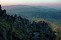
| 👁 Image View to the Katzenbuckel | |
| Highest point | |
| Elevation | 626 m (2,054 ft) |
| Isolation | 71 km (44 mi) |
| Coordinates | 49°28′15″N 9°02′28″E / 49.47083°N 9.04111°E / 49.47083; 9.04111 |
| Naming | |
English translation | Cat's arched back |
Language of name | German |
| Geography | |
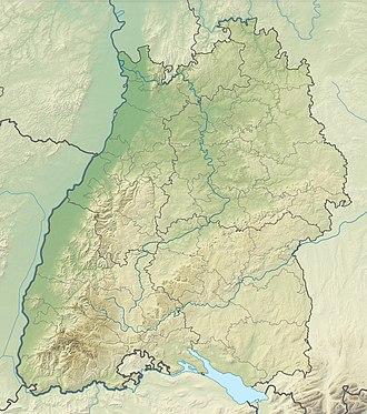
The location within Baden-Württemberg | |
| Location | Baden-Württemberg, Germany |
| Parent range | Odenwald |
The Katzenbuckel (German pronunciation: [ˈkatsn̩ˌbʊkl̩] ⓘ; 626 metres) is an extinct volcano and the highest elevation in the Odenwald region of southwest Germany. The mountain is located eastwards of Eberbach, near the village of Waldbrunn. At the top of the Katzenbuckel is an 18-m-high lookout, built out of sandstone. If the weather is good, it is possible to see the Donnersberg (83 km away) and the surrounding secondary mountains (Taunus). When the view is exceptionally clear, it is theoretically possible to see the Kreuzberg (120 km away) in the Rhön. It translates directly into 'cat hump'.
References
[edit]
Hidden categories:
- Pages using gadget WikiMiniAtlas
- Pages using the Phonos extension
- Articles with short description
- Short description matches Wikidata
- Articles lacking sources from May 2026
- All articles lacking sources
- Coordinates on Wikidata
- Pages using infobox mountain with language parameter
- Pages with German IPA
- Pages including recorded pronunciations
- All stub articles