
This article does not cite any sources. Please help improve this article by adding citations to reliable sources. Unsourced material may be challenged and removed. Find sources: "Kigach" – news · newspapers · books · scholar · JSTOR (May 2026) (Learn how and when to remove this message) |
| Kigach | |
|---|---|
| 👁 Image | |
| Location | |
| Country | Kazakhstan |
| Physical characteristics | |
| Source | Akhtuba |
| • coordinates | 46°36′28″N 48°15′39″E / 46.6078°N 48.2608°E / 46.6078; 48.2608 |
| Mouth | Shirokaya |
• coordinates | 46°28′19″N 48°49′15″E / 46.4719°N 48.8208°E / 46.4719; 48.8208 |
| Length | 378 km (235 mi) |
Basin size | 14,900 km2 (5,800 sq mi) |
| Basin features | |
| Progression | Shirokaya→ Caspian Sea |
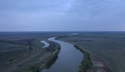
The Kigach (Russian: Кигач, Kazakh: Қиғаш, Qiğaş) is a river of southern Russia (Astrakhan Oblast) and Kazakhstan (Atyrau Region). A left distributary of the Akhtuba, it is part of the Volga Delta.
Retrieved from "https://en.wikipedia.org/w/index.php?title=Kigach&oldid=1352706507"
Hidden categories:
- Pages using gadget WikiMiniAtlas
- Articles lacking sources from May 2026
- All articles lacking sources
- Articles with short description
- Short description is different from Wikidata
- Pages using infobox mapframe without shape links in Wikidata
- Coordinates on Wikidata
- Pages using infobox river with mapframe
- Articles containing Russian-language text
- Articles containing Kazakh-language text
- All stub articles
- Pages using the Kartographer extension