
Koura District | |
|---|---|
| الكورة | |
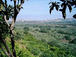
| 👁 Plains of Koura Plains of Koura | |
| 👁 Location in Lebanon Location in Lebanon | |
| Country | 👁 Image Lebanon |
| Governorate | North Governorate |
| Capital | Amioun |
| Area | |
• Total | 67 sq mi (173 km2) |
| Population | |
• Estimate (31 December 2017) | 75,056 |
| Time zone | UTC+2 (EET) |
| • Summer (DST) | UTC+3 (EEST) |
Koura District (Arabic: ٱلْكُورَة, from Greek: χώρα, lit. 'country') [1] is a district in the North Governorate, Lebanon.
_in_Lebanon.jpg)
Koura is one of the 26 districts of Lebanon, particularly known for its olive tree cultivation and olive oil production. It comprises a total of 52 villages, and its capital and largest town is Amioun, with about 10,000 inhabitants as of 2010. The district stretches from the Mediterranean Sea up to Mount Lebanon, and comprises a series of foothills surrounding a low-lying plain where olive is cultivated. The olive orchards of Koura are among the most extensive in Lebanon.
The University of Balamand is headquartered in the Koura District.
Demographics
[edit]According to registered voters in 2014:
| Year | Christians | Muslims | Druze | |||||||
|---|---|---|---|---|---|---|---|---|---|---|
| Total | Greek Orthodox | Maronites | Greek Catholics | Other Christians | Total | Sunnis | Shias | Alawites | Druze | |
| 2014[2] | 83.01% |
59.31% |
21.43% |
1.18% |
1.09% |
16.55% |
13.82% |
1.97% |
0.76% |
0.02% |
| 2018[3] | 82.87% |
58.64% |
21.56% |
1.18% |
1.49% |
17.1% |
14.32% |
1.99% |
0.79% |
0.02% |
| 2022[4] | 82.90% |
57.63% |
21.57% |
2.80% |
0.90% |
17.08% |
14.46% |
1.87% |
0.75% |
0.00% |
| 2026[5] | 81.24% |
61.83% |
18.85% |
—N/a | 0.56% |
18.76% |
15.72% |
2.07% |
0.97% |
0.00% |
Number of registered voters (21+ years old) over the years.
| Years | Men | Women | Total | Growth (%) |
|---|---|---|---|---|
| 2009 | 29,286 | 28,509 | 57,795 | —N/a |
| 2010 | 29,558 👁 Increase |
28,696 👁 Increase |
58,254 👁 Increase |
+0.79% 👁 Increase |
| 2011 | 28,642 👁 Decrease |
28,527 👁 Decrease |
57,169 👁 Decrease |
-1.90% 👁 Decrease |
| 2012 | 28,811 👁 Increase |
28,726 👁 Increase |
57,537 👁 Increase |
+0.64% 👁 Increase |
| 2013 | 29,267 👁 Increase |
29,066 👁 Increase |
58,333 👁 Increase |
+1.36% 👁 Increase |
| 2014 | 29,486 👁 Increase |
29,288 👁 Increase |
58,774 👁 Increase |
+0.75% 👁 Decrease |
| 2015 | 29,729 👁 Increase |
29,452 👁 Increase |
59,181 👁 Increase |
+0.69% 👁 Decrease |
| 2016 | 29,919 👁 Increase |
29,678 👁 Increase |
59,597 👁 Increase |
+0.70% 👁 Increase |
| 2017 | 30,234 👁 Increase |
29,935 👁 Increase |
60,169 👁 Increase |
+0.95% 👁 Increase |
| 2018 | 30,672 👁 Increase |
30,309 👁 Increase |
60,981 👁 Increase |
+1.33% 👁 Increase |
| 2019 | 30,989 👁 Increase |
30,577 👁 Increase |
61,566 👁 Increase |
+0.95% 👁 Increase |
| 2020 | 31,263 👁 Increase |
30,759 👁 Increase |
62,022 👁 Increase |
+0.74% 👁 Decrease |
| 2021 | 31,432 👁 Increase |
30,828 👁 Increase |
62,260 👁 Increase |
+0.38% 👁 Decrease |
| 2022 | 31,673 👁 Increase |
30,994 👁 Increase |
62,667 👁 Increase |
+0.65% 👁 Increase |
| 2023 | 31,757 👁 Increase |
31,017 👁 Increase |
62,774 👁 Increase |
+0.17% 👁 Decrease |
| 2024 | 31,923 👁 Increase |
31,155 👁 Increase |
63,078 👁 Increase |
+0.48% 👁 Increase |
| 2025 | 32,009 👁 Increase |
31,207 👁 Increase |
63,216 👁 Increase |
+0.22% 👁 Decrease |
| 2026 | —N/a | —N/a | 63,454 👁 Increase |
+0.38% 👁 Increase |
| Source: DGCS [1] | ||||
Cities and towns
[edit]| Major Cities | |||||
|---|---|---|---|---|---|
| Kfaraakka | Amioun | Enfeh | Deddeh | Kousba | Ras Maska |
| Cities and Towns | |||
|---|---|---|---|
| 1. Aaba | 2. Afsdik | 3. Ain Akrine | 4. Ali-al-Mouran |
| 5. Amioun | 6. Enfeh | 7. Badebhoun | 8. Barghoun |
| 9. Barsa | 10. Bdebba | 11. Batroumine | 12. Bishmizzine |
| 13. Bhabouch | 14. Bishriyata | 15. Bkomra | 16. Bneyel |
| 18. Btourram | 19. Btouratige | 20. Bkeftine | 21. Bnehran |
| 22. Bsarma | 23. Btaaboura | 24. Bziza | 25. Charlita |
| 26. Chira | 27. Dahr-al-Ain | 28. Darbechtar | 29. Darchmezzine |
| 30. Deddeh | 31. Fih | 32. Ijdebrine | 33. Kaftoun |
| 34. Kifraya | 35. Kelbata | 36. Kelhat | 37. Kfaraakka |
| 38. Kfarhata | 39. Kfarhazir | 40. Kaferkahel | 41. Kfarsaroun |
| 42. Kousba | 43. Maziriit Toula | 44. Mitrit | 45. Mijdel |
| 46. Nakhleh | 47. Rachedbine | 48. Ras Maska | 49. Wata Fares |
| 50. Zakroun | 51. Zakzouk | 52. Dhour Alhawa |
See also
[edit]References
[edit]- ^ Abdallah, Mirna. "Koura, North Lebanon".
- ^ https://lub-anan.com/المحافظات/الشمال/الكورة/المذاهب/
- ^ "Critical study in proportional election law". Lebanonfiles.com (in Arabic). 2018. Retrieved 15 June 2018.
{{cite web}}: CS1 maint: url-status (link) - ^ "Mapping Lebanon: Data and statistics". today.lorientlejour.com (in English). 2022. Retrieved 5 October 2022.
{{cite web}}: CS1 maint: url-status (link) - ^ "Statify Lebanon". statisticslebanon.lb (in English). 2022. Retrieved 5 October 2022.
{{cite web}}: CS1 maint: url-status (link)
34°17′57″N 35°48′50″E / 34.2992°N 35.814°E / 34.2992; 35.814
- CS1 maint: url-status
- Pages using gadget WikiMiniAtlas
- Use dmy dates from August 2023
- Articles with short description
- Short description is different from Wikidata
- Pages using infobox settlement with no coordinates
- Articles containing Arabic-language text
- Articles containing Greek-language text
- Coordinates on Wikidata