
Kozina | |
|---|---|
| 👁 Image | |
Location in Slovenia | |
| Coordinates: 45°36′32.8″N 13°56′11.57″E / 45.609111°N 13.9365472°E / 45.609111; 13.9365472 | |
| Country | 👁 Image Slovenia |
| Traditional region | Littoral |
| Statistical region | Coastal–Karst |
| Municipality | Hrpelje-Kozina |
| Area | |
• Total | 2.96 km2 (1.14 sq mi) |
| Elevation | 492.7 m (1,616 ft) |
| Population (2020) | |
• Total | 664 |
| [1] | |
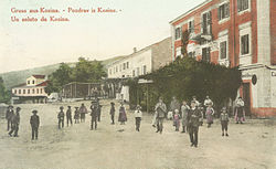
Kozina (pronounced [kɔˈziːna] ⓘ; Italian: Cosina) is a settlement in the Municipality of Hrpelje-Kozina in the Littoral region of Slovenia, close to the border with Italy.[2]
The village developed only after the railway was established; in 1825 there were only three houses in Kozina. It became an important center for teamsters, with twelve inns with stalls for teamsters' horses.[3] Today it lies at the intersection of the A1 motorway (Ljubljana–Koper) with Route 7 (Trieste–Rijeka).
References
[edit]- ^ Statistical Office of the Republic of Slovenia. stat.si
- ^ Hrpelje-Kozina municipal site Archived 2008-12-18 at the Wayback Machine. hrpelje-kozina.si
- ^ Savnik, Roman (1968). Krajevni leksikon Slovenije, vol. 1. Ljubljana: Državna založba Slovenije. p. 318.
External links
[edit]- 👁 Wikimedia Commons logo
Media related to Kozina at Wikimedia Commons - Kozina on Geopedia
Retrieved from "https://en.wikipedia.org/w/index.php?title=Kozina&oldid=1253414971"
Hidden categories:
- Pages using gadget WikiMiniAtlas
- Pages using the Phonos extension
- Webarchive template wayback links
- Articles with short description
- Short description is different from Wikidata
- Coordinates on Wikidata
- Pages with Slovene IPA
- Pages including recorded pronunciations
- Articles containing Italian-language text
- Commons category link from Wikidata
- All stub articles