
| Lauchert | |
|---|---|
| 👁 Image | |
| Location | |
| Country | Germany |
| Physical characteristics | |
| Source | |
| • location | Swabian Alb |
| Mouth | |
• location | Danube |
• coordinates | 48°3′46″N 9°15′49″E / 48.06278°N 9.26361°E / 48.06278; 9.26361 |
| Length | 60.4 km (37.5 mi)[1] |
| Basin size | 456 km2 (176 sq mi)[1] |
| Basin features | |
| Progression | Danube→ Black Sea |
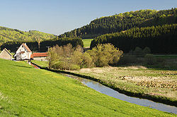
The Lauchert (German pronunciation: [ˈlaʊxɐt] ⓘ) is a river in Baden-Württemberg, Germany, left tributary of the Danube. Its source is near Sonnenbühl, in the Swabian Alb. It is approx. 60 km long. It flows generally south through the small towns Gammertingen, Veringenstadt and Bingen. It flows into the Danube in Sigmaringendorf.
References
[edit]
Retrieved from "https://en.wikipedia.org/w/index.php?title=Lauchert&oldid=1302186173"
Hidden categories:
- Pages using gadget WikiMiniAtlas
- Pages using the Phonos extension
- Articles with short description
- Short description matches Wikidata
- Coordinates on Wikidata
- Pages using infobox river with mapframe
- Pages with German IPA
- Pages including recorded pronunciations
- All stub articles
- Pages using the Kartographer extension