
Lemland | |
|---|---|
Municipality | |
| Lemlands kommun | |
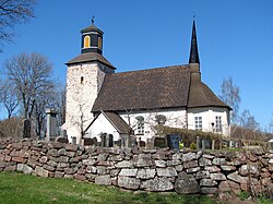
| 👁 The medieval parish church in Lemland. The medieval parish church in Lemland. | |
|
👁 Coat of arms of Lemland Coat of arms | |
| 👁 Location of Lemland in Finland Location of Lemland in Finland | |
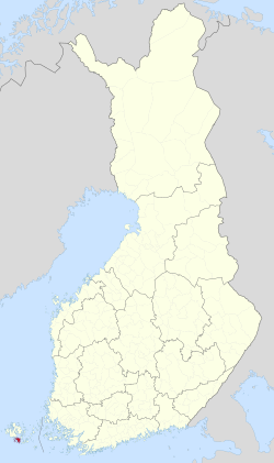
Location in Åland | |
| Coordinates: 60°04.2′N 020°05.2′E / 60.0700°N 20.0867°E / 60.0700; 20.0867 | |
| Country | 👁 Image Finland |
| Region | Åland |
| Sub-region | Countryside |
| Government | |
| • Municipal manager | Mikael Smeds |
| Area (2018-01-01)[1] | |
• Total | 965.30 km2 (372.70 sq mi) |
| • Land | 113.21 km2 (43.71 sq mi) |
| • Water | 852.23 km2 (329.05 sq mi) |
| • Rank | 293rd largest in Finland |
| Population (2025-12-31)[2] | |
• Total | 2,139 |
| • Rank | 250th largest in Finland |
| • Density | 18.89/km2 (48.9/sq mi) |
| Population by native language | |
| • Swedish | 90.6% (official) |
| • Finnish | 3.4% |
| • Others | 6% |
| Population by age | |
| • 0 to 14 | 20.6% |
| • 15 to 64 | 61.2% |
| • 65 or older | 18.2% |
| Time zone | UTC+02:00 (EET) |
| • Summer (DST) | UTC+03:00 (EEST) |
| Website | www.lemland.ax 👁 Edit this at Wikidata |
Lemland is a municipality of Åland, an autonomous territory of Finland. Covering a land area of 113.21 km2 (43.71 sq mi), it had a population of 2,133 in 2025. The majority of Lemland's population speaks Swedish. The Lemström Canal, carved in 1882, separates Åland’s main island from the Lemland peninsula. Historically, the municipality has been an important maritime hub, given its strategic location in the Baltic Sea.
History
[edit]Evidence of early human activity in Åland dates back to around 5000 BC, with the early seasonal settlement developing into a permanent settlement later.[5] During the Viking era (8th to 11th century CE), the islands assumed strategic importance.[6] Aland came under the Swedish influence in the 13th century.[5] The Lemland Church, a significant historical landmark, was built in stages, with its oldest parts dating prior to 15th century. Though the current structure is dated to 15th century, the original structure built in the 13th century had paintings in the ceilings and wooden sculptures dated added in the 14th century. It is dedicated to Bridget of Sweden.[7][8] During the Finnish War in 1808, the Swedish king Gustav IV Adolf had his headquarters in the Lemland parsonage.[9] As per Håkan Skogsjö, the ancestry of the permanently residing population of Lemland and owners of farmsteads could be traced back to the 18th century.[10][11]
Geography
[edit]Lemland is a municipality located in the autonomous region of Åland.[12][13] The municipality spans an area of approximately 965.3 km2 (372.7 sq mi) of which 852.23 km2 (329.05 sq mi) is covered by water.[1][14] The Lemström Canal, carved in 1882, connects the sea inlet east of Mariehamn, the capital of Åland and Lumparn. There is a bridge over the canal.[15]
Climate
[edit]| Climate data for Lemland Nyhamn (1991–2020 normals, extremes 1959–present) | |||||||||||||
|---|---|---|---|---|---|---|---|---|---|---|---|---|---|
| Month | Jan | Feb | Mar | Apr | May | Jun | Jul | Aug | Sep | Oct | Nov | Dec | Year |
| Record high °C (°F) | 8.5 (47.3) |
7.8 (46.0) |
11.1 (52.0) |
16.4 (61.5) |
23.5 (74.3) |
26.5 (79.7) |
28.7 (83.7) |
26.9 (80.4) |
21.4 (70.5) |
16.4 (61.5) |
12.7 (54.9) |
9.3 (48.7) |
28.7 (83.7) |
| Daily mean °C (°F) | 0.2 (32.4) |
−1.1 (30.0) |
0.4 (32.7) |
3.2 (37.8) |
7.7 (45.9) |
12.4 (54.3) |
16.7 (62.1) |
16.9 (62.4) |
13.1 (55.6) |
8.3 (46.9) |
4.6 (40.3) |
2.1 (35.8) |
7.0 (44.6) |
| Record low °C (°F) | −29.2 (−20.6) |
−24.9 (−12.8) |
−17.3 (0.9) |
−12.8 (9.0) |
−1.2 (29.8) |
2.2 (36.0) |
6.4 (43.5) |
4.0 (39.2) |
2.0 (35.6) |
−3.0 (26.6) |
−8.5 (16.7) |
−23.0 (−9.4) |
−29.2 (−20.6) |
| Source 1: FMI climatological normals for Finland 1991–2020[16] | |||||||||||||
| Source 2: Record highs and lows 1959–present[17] | |||||||||||||
Demographics
[edit]The municipality has a population of 2,139 (31 December 2025)[2][18] Males and females constituted almost equal proportion of the population, with 526 individuals under the age of 17 years. Almost the entire population is classified as rural. Swedish language is spoken by majority (90.6%) of the population. About 81.9% of the population identified as Finnish citizens.[12]
Gallery
[edit]-
St. Olof's Chapel
-
Lemström Canal
-
Rödhamn Harbour.
-
Tower of Herrö
References
[edit]- ^ a b "Area of Finnish Municipalities 1.1.2018" (PDF). National Land Survey of Finland. Retrieved 30 January 2018.
- ^ a b c "Population growth slowed down in 2025". Population structure. Statistics Finland. 1 April 2026. ISSN 2243-3627. Retrieved 6 April 2026.
- ^ "Population according to age (1-year) and sex by area and the regional division of each statistical reference year, 2003–2020". StatFin. Statistics Finland. Retrieved 2 May 2021.
- ^ a b "Luettelo kuntien ja seurakuntien tuloveroprosenteista vuonna 2023". Tax Administration of Finland. 14 November 2022. Retrieved 7 May 2023.
- ^ a b "History of Åland". Visit Åland. Retrieved 18 June 2025.
- ^ "Viking Finland". Forbes. 18 September 2023. Retrieved 1 June 2025.
- ^ "Lemland Church - Åland Museum". Åland Museum. Retrieved 18 June 2025.
- ^ "Lemland Church". Visit Aland. Retrieved 1 June 2025.
- ^ Torsten Hellberg (2011). Åland – mer än öar. p. 19.
- ^ Skogsjö, Håkan (2005). Ålands släktregister. D. 7:1 Familjer och gårdar i Lemland: från stormaktstid till nutid (in Swedish). Mariehamn: Håkan Skogsjö. pp. 1–738. ISBN 9529964013.
- ^ Skogsjö, Håkan (2005). Ålands släktregister. D. 7:2 Familjer och gårdar i Lemland: från stormaktstid till nutid (in Swedish). Mariehamn: Håkan Skogsjö. pp. 1–729. ISBN 9529964021.
- ^ a b "Lemland area and population". City Population.de. Retrieved 17 June 2025.
- ^ "Lemland". Geonames. Retrieved 1 June 2025.
- ^ "Area of municipalities of Finland". National Land Survey of Finland. Retrieved 18 June 2025.
- ^ "Lemstrom Canal". Visit Åland. Retrieved 18 June 2025.
- ^ "FMI normals 1991–2020". fmi.fi. Retrieved 23 April 2023.
- ^ "FMI open data". FMI. Retrieved 21 May 2023.
- ^ "Lemland growth and position". Ålands statistik- och utredningsbyrå. Retrieved 17 June 2025.
External links
[edit]👁 Wikimedia Commons logo
Media related to Lemland at Wikimedia Commons
- Municipality of Lemland – Official website
- Pages using gadget WikiMiniAtlas
- Pages with non-numeric formatnum arguments
- CS1 Swedish-language sources (sv)
- Use dmy dates from May 2024
- Articles with short description
- Short description is different from Wikidata
- Articles containing Swedish-language text
- Coordinates on Wikidata
- Pages using gallery without a media namespace prefix
- Commons category link is on Wikidata