
Manching | |
|---|---|
|
👁 Coat of arms of Manching Coat of arms | |
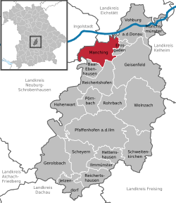
Location of Manching
within Pfaffenhofen a.d.Ilm district | |
Location of Manching | |
| Coordinates: 48°43′7″N 11°29′50″E / 48.71861°N 11.49722°E / 48.71861; 11.49722 | |
| Country | Germany |
| State | Bavaria |
| Admin. region | Oberbayern |
| District | Pfaffenhofen a.d.Ilm |
| Government | |
| • Mayor (2020–26) | Herbert Nerb[1] (FW) |
| Area | |
• Total | 35.48 km2 (13.70 sq mi) |
| Elevation | 366 m (1,201 ft) |
| Population (2024-12-31)[2] | |
• Total | 13,042 |
| • Density | 367.6/km2 (952.0/sq mi) |
| Time zone | UTC+01:00 (CET) |
| • Summer (DST) | UTC+02:00 (CEST) |
| Postal codes | 85077 |
| Dialling codes | 08459 |
| Vehicle registration | PAF |
| Website | www.manching.de |
Manching (German pronunciation: [ˈmançɪŋ] ⓘ) is a municipality in the district of Pfaffenhofen, in Bavaria, Germany. It is situated on the river Paar, 7 km southeast of Ingolstadt. In the late Iron Age, there was a Celtic settlement, the Oppidum of Manching, on the location of present-day Manching.
Airbus Defence and Space (former Military Air Systems business unit of EADS) has its flight test center here at Manching Airport.
The Barthelmarkt, a well-known beer festival in the area, takes place in the district of Oberstimm [de] on the last weekend of August every year.
References
[edit]- ^ Liste der ersten Bürgermeister/Oberbürgermeister in kreisangehörigen Gemeinden, Bayerisches Landesamt für Statistik, 15 July 2021.
- ^ "Gemeinden, Kreise und Regierungsbezirke in Bayern, Einwohnerzahlen am 31. Dezember 2024; Basis Zensus 2022" [Municipalities, counties, and administrative districts in Bavaria; Based on the 2022 Census] (CSV) (in German). Bayerisches Landesamt für Statistik.
Retrieved from "https://en.wikipedia.org/w/index.php?title=Manching&oldid=1290397422"
Hidden categories:
- Pages using gadget WikiMiniAtlas
- Pages using the Phonos extension
- CS1 German-language sources (de)
- Articles with short description
- Short description is different from Wikidata
- Coordinates on Wikidata
- Pages using infobox settlement with potentially too many maps
- Pages with German IPA
- Pages including recorded pronunciations
- All stub articles
- Pages using the Kartographer extension