
| Meishe River | |
|---|---|
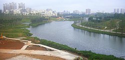
| 👁 Image Meishe River entering Meishe River National Wetland Park | |
| Native name | 美舍河 (Chinese) |
| Physical characteristics | |
| Source | Shapo Reservoir |
| • location | Haikou, Hainan, China |
| Mouth | Haidian River |
• location | Haikou, Hainan, China |
| Length | 10 km approx. |
The Meishe River (Chinese: 美舍河) is a river within Haikou City, Hainan, China.[1][2] Its source is the spillway at the east end of the Shapo Reservoir located just south of the city. The Meishe flows eastward under Longkun Road south of the Haikou East Railway Station. It then turns north, past the Meishe River National Wetland Park and winds northward through the east side of urban Haikou, under Guoxing Avenue, finally emptying into the Haidian River just east of Heping Bridge.
References
[edit]- ^ "哇~原来这才是海口美舍河颜值的"新高度"!". www.sohu.com. Retrieved 2 January 2019.
- ^ "中国海口政府门户网站". Haikou.gov.cn. 2018-08-13. Retrieved 2019-01-02.
External links
[edit]- 👁 Wikimedia Commons logo
Media related to Meishe River at Wikimedia Commons
19°58′49″N 110°21′23″E / 19.9802°N 110.3565°E / 19.9802; 110.3565
Hidden categories:
- Pages using gadget WikiMiniAtlas
- Articles with short description
- Short description matches Wikidata
- Pages using infobox mapframe without shape links in Wikidata
- Articles containing Chinese-language text
- Pages using infobox river with mapframe
- Articles containing simplified Chinese-language text
- Commons category link is on Wikidata
- Coordinates on Wikidata
- All stub articles
- Pages using the Kartographer extension