
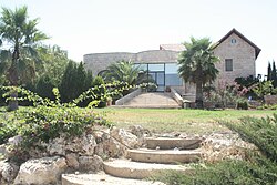
Mevo Beitar
| |
|---|---|
| 👁 Image | |
| Etymology: Beitar Gateway | |
| Coordinates: 31°43′21″N 35°6′24″E / 31.72250°N 35.10667°E / 31.72250; 35.10667 | |
| Country | Israel |
| District | Jerusalem |
| Council | Mateh Yehuda |
| Affiliation | Mishkei Herut Beitar |
| Founded | 24 April 1950 |
| Founded by | Beitar members |
| Population (2024)[1] | 1,153 |
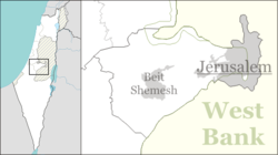
Mevo Beitar (Hebrew: מְבוֹא בֵּיתָר, lit. Beitar Gateway) is a moshav shitufi in central Israel. Located ten kilometres south-west of Jerusalem in the Jerusalem corridor, it falls under the jurisdiction of Mateh Yehuda Regional Council. In 2024 it had a population of 1,153.[1]
History
[edit]The village was established near the Betar fortress on 24 April 1950 by native Israelis and immigrants from Argentina who were members of the Beitar movement, including Matityahu Drobles, later a member of the Knesset.[2] It was founded on the land of the depopulated Arab village of al-Qabu.[3] Located around a kilometre from the Green Line, it was a "Sefer settlement [he]" (which meant it was entitled to financial compensation) until the Six-Day War.
References
[edit]- ^ a b "Regional Statistics". Israel Central Bureau of Statistics. Retrieved 21 March 2026.
- ^ About Mevo Beitar
- ^ Khalidi, Walid (1992), All That Remains: The Palestinian Villages Occupied and Depopulated by Israel in 1948, Washington D.C.: Institute for Palestine Studies, p. 308, ISBN 0-88728-224-5