
| Mount Kasa | |
|---|---|
| 笠ヶ岳 | |
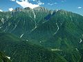
| 👁 Image Mount Kasa from Mount Yari | |
| Highest point | |
| Elevation | 2,897.48 m (9,506.2 ft)[1] |
| Listing | List of mountains in Japan 100 Famous Japanese Mountains |
| Coordinates | 36°18′55″N 137°37′00″E / 36.31528°N 137.61667°E / 36.31528; 137.61667[2] |
| Naming | |
| Language of name | Japanese |
| Pronunciation | [kasaɡatake] |
| Geography | |
| Parent range | Hida Mountains |
| Topo map(s) | Geospatial Information Authority 25000:1 笠ヶ岳[2] 50000:1 上高地 |
| Climbing | |
| First ascent | 1683(Enkū) |
| Easiest route | Hike |
Mount Kasa (笠ヶ岳, Kasa-ga-take) is one of the 100 Famous Japanese Mountains, reaching the height of 2,897 m (9,505 ft). It is situated in Japan's Hida Mountains in Gifu Prefecture and in Chūbu-Sangaku National Park.[3] The shape of the mountain looks like the Umbrella("Kasa"-笠) in the triangle. Therefore, it became this name.[4] There are many mountains with same name in Japan and this is the tallest.
History
[edit]- In 1683 – It was said that Enkū had opened this mountain.[5]
- In 1823 – The Buddhist monk Banryū climbed to the top, and placed a bronze Buddha statue at the top in 1824.[6]
- In 1894, August 2 – Englishman Walter Weston had climbed on the top.[7]
- In 1913, August – Usui Kojima had climbed on the top.[5]
- In 1932 – Mountain hut of Kasa Mountain Cottage (笠ヶ岳山荘) was constructed near the top.[8]
- In 1934, December 4 – This area was specified to the Chūbu-Sangaku National Park.[3]
- In 1964 – "Kasa-shin-dō"(笠新道) of the new Trail had been made.[4] Then it is the main route to the Mount Kasa.
- In 1993 – Postage stamp of Mount Kasa and Takayama Festival was put on the market by the Ministry of Posts and Telecommunications (Japan).[9]
- In 1995 – Sumie Tanaka (田中澄江 Tanaka Sumie) completed New Flowers of the 100 Mountains, which featured many of the Alpine plant(Trollius japonicus シナノキンバイ and others) on Mount Kasa.[10]
Mountaineering
[edit]Main ascent routes
[edit]
There are three climbing routes to the top of the mountain.[11][12]
- Kasa-shin-dō
- Shin-Hotaka Onsen (新穂高温泉) – Mount Nukedo – Kasa Mountain Cottage – Mount Kasa
- Valley Kuriya
- Nakao-Kōgen-guchi (中尾高原口) – Valley Kuriya – Mount Kasa
- Traverses Route of Northern Japanese Alps (Hida Mountains) from north side
- Mount Sugoroku – Mount Yumiori – Mount Nukedo – Kasa Mountain Cottage – Mount Kasa
Mountain hut
[edit]Thera are several Mountain hut around Mount Kasa.[12] Around Shin-Hotaka-Onsen, there are many hot spring (Onsen) to take the tiredness and to relax.
- Kasa Mountain Cottage (笠ヶ岳山荘) – near the top (with Campsite)
- Wasabi-Daira Hut (ワサビ平小屋) – near the entrance of Kasa-shin-dō
- Kagami-Daira Mountain Cottage (鏡平山荘) – near the Pond Kagami(鏡池)
- Sugoroku Hut (双六小屋) – between Mount Sugoroku and Mount Momisawa (with Campsite)
Geography
[edit]
It is the mountain that consists chiefly of the Porphyry (geology).[4] The higher region than Shakushi-daira (杓子平) are the forest limit of Siberian Dwarf Pine belt, and the place that Alpine plant grows naturally and Rock Ptarmigan live.
Nearby mountains
[edit]Mount Kasa is on the subridge (from Mount Sugoroku) of the main ridge line in the southern part of the Hida Mountains.[11] There are Mount Shakujō and Mount Ōkibanotsuji on the southern ridge.
| Image | Mountain | Elevation | Distance from the Top |
Note |
|---|---|---|---|---|
| 👁 Image |
Mount Yari 槍ヶ岳 |
3,180 m (10,433 ft) | 9.2 km (5.7 mi) | 100 Famous Japanese Mountains |
| 👁 Image |
Mount Kasa 笠ヶ岳 |
2,897 m (9,505 ft) | 0 km (0.0 mi) | 100 Famous Japanese Mountains |
| 👁 Image |
Mount Shakujō 錫杖岳 |
2,168 m (7,113 ft) | 3.8 km (2 mi) | Rock climbing on the rock peak |
| 👁 Image |
Mount Hotaka 穂高岳 |
3,190 m (10,466 ft) | 9.2 km (6 mi) | Tallest mountain in Hida Mountains 100 Famous Japanese Mountains |
| 👁 Image |
Mount Haku 白山 |
2,702 m (8,865 ft) | 72.3 km (44.9 mi) | Tallest mountain in Ishikawa Prefecture 100 Famous Japanese Mountains |
Rivers
[edit]The mountain is the source of the following rivers, each of which flows to the Sea of Japan.[12]
- Sugoroku River (a tributary of the Jinzū River)
- Gamata River (tributaries of the Takahara River)
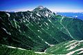
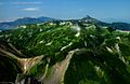
Gallery
[edit]-
Mount Kasa
from Mount Nukedo -
Mount Kasa
from south -
Mount Kasa
from Mount Kurai -
Mount Kasa and Hida Mountains
from Mount Suisho
References
[edit]- ^ "Information inspection service of the Triangulation station". Geospatial Information Authority of Japan,(高山-上高地-笠ヶ岳). Archived from the original on June 9, 2009. Retrieved December 1, 2010.
- ^ a b "Map inspection service". Geospatial Information Authority of Japan,(高山-上高地-笠ヶ岳). Retrieved December 1, 2010.
- ^ a b "Chūbu-Sangaku National Park". Ministry of the Environment (Japan). Archived from the original on February 27, 2012. Retrieved December 1, 2010.
- ^ a b c Dictionary of name of Japanese mountain (日本山名辞典). Sanseido. 1992. p. 122. ISBN 4-385-15403-1.
- ^ a b 1000 Japanese Mountains. YAMA-KEI Publishers. 1992. ISBN 4-635-09025-6.
- ^ "THE HOTAKA MOUNTAIN RANGE – Chubusangaku National Park". chubusangaku.jp. Retrieved 2024-07-16.
- ^ Mountaineeraing and exploration in Japanese alps, (in 1896 by Walter Weston) (new ed.). translated into Japanese (日本アルプスの登山と探検), Iwanami Shoten. 2005. ISBN 4-00-334741-2.
- ^ The story of mountain huts in Northern Japanese Alps. Tokyo Shimbun. 1997. ISBN 4-8083-0374-4.
- ^ 100 Famous Japanese Mountains with postmark of stamp with the scenery. Hukurōsha. 2007. ISBN 978-4-89806-276-0.
- ^ Sumie Tanaka (1995). New Flowers of the 100 Mountains (新・花の百名山). Bunsyunbunko. ISBN 4-16-731304-9.
- ^ a b Alpen guide Kamikōchi, Mount Yari and Mount Hotaka (アルペンガイド). YAMA-KEI Publishers. 2000. ISBN 4-635-01319-7.
- ^ a b c Mountain and plateau map, Mount Yari, Mount Hotaka and Kamikōchi (山と高原地図). Shobunsha Publications. 2010. ISBN 978-4-398-75717-3.