
| Mount Takami | |
|---|---|
| 高見山 | |
| 👁 Image Mount Takami from Hirano(January 2009) | |
| Highest point | |
| Elevation | 1,248.3 m (4,095 ft) |
| Listing | List of mountains and hills of Japan by height |
| Coordinates | 34°25′44″N 136°05′17″E / 34.429°N 136.088°E / 34.429; 136.088 |
| Naming | |
| Language of name | Japanese |
| Geography | |
| Location | On the border of Higashiyoshino, Nara, and Matsusaka, Mie, Japan |
| Parent range | Daiko Mountains |
Mount Takami (高見山, Takami-san/Takami-yama) is a 1,248.3 m (4,095 ft) mountain of Daiko Mountains, which is located on the border of Higashiyoshino, Nara, and Matsusaka, Mie, Japan
Outline
[edit]This mountain is located on the north end of Daiko Mountains. This mountain is considered one of the 300 Famous Japanese Mountains. This mountain is an important part of Muro-Akame-Aoyama Quasi National Park.
Routes
[edit]This mountain is very famous for the beautiful frost patterns that form on trees in winter and so attract many climbers. There are several routes to reach the top; one is from Takami-Otoge Pass and it takes about one hour; another route is from Takami-tozanguchi Bus Stop on the Nara Kotsu bus route, and it takes two and a half hours. The third route is from Shimo-Hirano Bus stop, also on the Nara Kotsu bus route, and it also takes two and a half hours.
Gallery
[edit]-
Takasumi Shrine at the top of Mount Takami (January 2009)
-
Omine Mountains from Mount Takami (January 2009)
-
Eastside view of Mount Takami (January 2009)
-
Daiko Mountains from Mount Takami (January 2009)
-
Katsuragi Mountains from Mount Takami (January 2009)
-
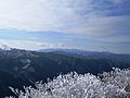
Frosts on trees at the top of Mount Takami (1) (January 2009)
-
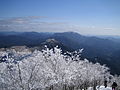
Frosts on trees at the top of Mount Takami (2) (January 2009)
-
Takamisugi Cedar
References
[edit]
- Articles with short description
- Short description is different from Wikidata
- Pages using gadget WikiMiniAtlas
- Pages using infobox mapframe without shape links in Wikidata
- Pages using infobox mountain with language parameter
- Articles containing Japanese-language text
- Commons category link is on Wikidata
- Pages using the Kartographer extension