
Nassogne
| |
|---|---|
| 👁 Image | |
|
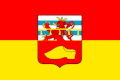
👁 Coat of arms of Nassogne Coat of arms | |
| 👁 Location of Nassogne in Luxembourg province Location of Nassogne in Luxembourg province | |
Interactive map of Nassogne | |
Location in Belgium | |
| Coordinates: 50°08′N 05°21′E / 50.133°N 5.350°E / 50.133; 5.350 | |
| Country | Belgium |
| Community | French Community |
| Region | Wallonia |
| Province | Luxembourg |
| Arrondissement | Marche-en-Famenne |
| Government | |
| • Mayor | Marc Quirynen |
| • Governing party | Intérêts Communaux Nassogne (ICN) |
| Area | |
• Total | 113.11 km2 (43.67 sq mi) |
| Population (2018-01-01)[1] | |
• Total | 5,474 |
| • Density | 48.40/km2 (125.3/sq mi) |
| Postal codes | 6950-6953 |
| NIS code | 83040 |
| Area codes | 084 |
| Website | nassogne.be |
Nassogne (French pronunciation: [nasɔɲ]) is a municipality of Wallonia located in the province of Luxembourg, Belgium.
On 1 January 2007 the municipality, which covers 111.96 km2, had 5,045 inhabitants, giving a population density of 45.1 inhabitants per km2.
The municipality consists of the following districts: Ambly, Bande, Forrières, Grune, Harsin, Lesterny, Masbourg (including Mormont), and Nassogne.
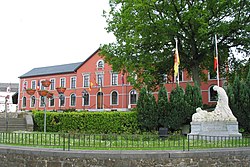
The "monument aux morts de Nassogne" is a World War I memorial sculpture in Nassogne, made by artist Mercédès Legrand.[2]
See also
[edit]References
[edit]- ^ "Wettelijke Bevolking per gemeente op 1 januari 2018". Statbel. Retrieved 9 March 2019.
- ^ "Mercédès Legrand au Famenne & Art Museum". TV Lux (in Belgian French). January 4, 2021.
External links
[edit]- 👁 Wikimedia Commons logo
Media related to Nassogne at Wikimedia Commons - Official website (in French)
Retrieved from "https://en.wikipedia.org/w/index.php?title=Nassogne&oldid=1311670422"
Hidden categories:
- Pages using gadget WikiMiniAtlas
- CS1 Belgian French-language sources (fr-be)
- Articles with short description
- Short description matches Wikidata
- Short description is different from Wikidata
- Coordinates on Wikidata
- Pages using infobox settlement with potentially too many maps
- Pages with French IPA
- Commons category link from Wikidata
- All stub articles
- Pages using the Kartographer extension