
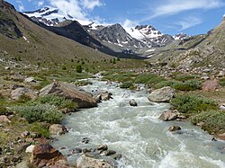
| Plima | |
|---|---|
| 👁 Image | |
| Location | |
| Country | Italy |
| Physical characteristics | |
| Source | |
| • location | Martelltal (South Tyrol) |
| Mouth | Adige |
• coordinates | 46°37′08″N 10°50′17″E / 46.61889°N 10.83806°E / 46.61889; 10.83806 |
• elevation | 650 m (2,130 ft) |
| Length | 28.5 km (17.7 mi) |
| Basin size | 162 km2 (63 sq mi) |
| Basin features | |
| Progression | Adige→ Adriatic Sea |
The Plima (Italian: Rio Plima; German: Plima) is a stream in South Tyrol, Italy. It flows into the Adige near Latsch.
References
[edit]- Civic Network of South Tyrol (in German and Italian)
Retrieved from "https://en.wikipedia.org/w/index.php?title=Plima&oldid=1290518518"
Hidden categories:
- Pages using gadget WikiMiniAtlas
- Articles with short description
- Short description matches Wikidata
- Pages using infobox mapframe without shape links in Wikidata
- Coordinates on Wikidata
- Pages using infobox river with mapframe
- Articles containing Italian-language text
- Articles containing German-language text
- Articles with German-language sources (de)
- Articles with Italian-language sources (it)
- All stub articles
- Pages using the Kartographer extension