
| Salhyr Салгир (Ukrainian) Salğır (Crimean Tatar) Салгир (Russian) Salgir | |
|---|---|
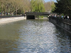
| 👁 Image Salhyr River flowing through Simferopol | |
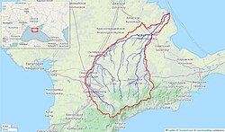
| 👁 Image Salhyr River watershed (Interactive map) | |
| Physical characteristics | |
| Source | |
| • location | Chatyrdag, Crimea |
| Mouth | |
• location | Syvash of the Azov Sea |
| Length | 204 km (127 mi) |
| Basin size | 3,750 km2 (1,450 sq mi) |
| Discharge | |
| • average | 2 m3/s (71 cu ft/s) |
The Salhyr[a] or Salgir[b] is the longest river of the Crimean Peninsula. Its length is 204 km, and its drainage basin is 3,750 km2. The average discharge of the water is 2 m3/s.[1]
It is formed in the Chatyr-Dag mountains southeast of Simferopol, passes that town, and flows north and increasingly east to reach the Syvash of the Azov Sea. Along the way, the river passes through the North Crimean Canal, previously a large affluent water from Byuk Karasu River up north Novoivanovka (Nizhnegorsk). It is mainly used for hydroelectricity and agricultural usage.[citation needed]
Notes
[edit]- ^
- Ukrainian: Салгир
- Crimean Tatar: Salğır
- ^ Russian: Салгир
References
[edit]- ^ Simferopol. UKRTravel. Accessed April 17, 2012.
45°38′53″N 35°00′22″E / 45.64806°N 35.00611°E / 45.64806; 35.00611
Retrieved from "https://en.wikipedia.org/w/index.php?title=Salhyr&oldid=1296963890"
Hidden categories:
- Articles containing Ukrainian-language text
- Articles containing Crimean Tatar-language text
- Articles containing Russian-language text
- Pages using gadget WikiMiniAtlas
- Articles with short description
- Short description is different from Wikidata
- Pages using infobox mapframe without shape links in Wikidata
- All articles with unsourced statements
- Articles with unsourced statements from October 2015
- Coordinates on Wikidata
- All stub articles
- Pages using the Kartographer extension