
Sorico
Suregh (Lombard) | |
|---|---|
| Comune di Sorico | |
|
👁 Coat of arms of Sorico Coat of arms | |
Location of Sorico in Italy Sorico (Lombardy) | |
| Coordinates: 46°10′N 9°23′E / 46.167°N 9.383°E / 46.167; 9.383 | |
| Country | Italy |
| Region | Lombardy |
| Province | Province of Como (CO) |
| Frazioni | Albonico, Bugiallo, Dascio |
| Area | |
• Total | 23.3 km2 (9.0 sq mi) |
| Population (Dec. 2004)[2] | |
• Total | 1,188 |
| • Density | 51.0/km2 (132/sq mi) |
| Time zone | UTC+1 (CET) |
| • Summer (DST) | UTC+2 (CEST) |
| Postal code | 22010 |
| Dialing code | 0344 |
| Website | Official website |
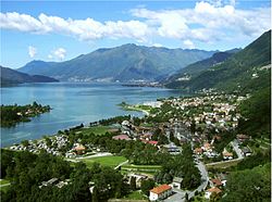
Sorico (Comasco: Suregh [ˈsuːrek]) is a comune (municipality) in the Province of Como in the Italian region Lombardy, located about 80 kilometres (50 mi) north of Milan and about 45 kilometres (28 mi) northeast of Como. As of 31 December 2004, it had a population of 1,188 and an area of 23.3 square kilometres (9.0 mi2).[3]
The municipality of Sorico contains the frazioni (subdivisions, mainly villages and hamlets) Albonico, Bugiallo, and Dascio.
Sorico borders the following municipalities: Dubino, Gera Lario, Montemezzo, Novate Mezzola, Samolaco, Verceia.
Demographic evolution
[edit]
Transport and Tourism
[edit]Sorico is a stopping point on the bus service that links Como to Colico via the west side of Lake Como. It is the northern endpoint of the long-distance footpath, La Via dei Monti Lariani.
References
[edit]- ^ "Superficie di Comuni Province e Regioni italiane al 9 ottobre 2011". Italian National Institute of Statistics. Retrieved 16 March 2019.
- ^ "Popolazione Residente al 1° Gennaio 2018". Italian National Institute of Statistics. Retrieved 16 March 2019.
- ^ All demographics and other statistics: Italian statistical institute Istat.
External links
[edit]
- Pages using gadget WikiMiniAtlas
- Pages using the EasyTimeline extension
- Articles with short description
- Short description is different from Wikidata
- Articles containing Lombard-language text
- Articles containing Italian-language text
- Coordinates on Wikidata
- Pages with Lombard IPA
- Commons category link from Wikidata
- All stub articles