
Szenta | |
|---|---|
Village | |
| 👁 Reformed Church in Szenta Reformed Church in Szenta | |
|
👁 Coat of arms of Szenta Coat of arms | |
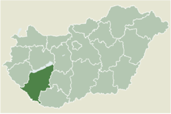
| 👁 Location of Somogy county in Hungary Location of Somogy county in Hungary | |
Location of Szenta | |
| Coordinates: 46°15′06″N 17°10′20″E / 46.25163°N 17.17223°E / 46.25163; 17.17223 | |
| Country | 👁 Image Hungary |
| Region | Southern Transdanubia |
| County | Somogy |
| District | Csurgó |
| RC Diocese | Kaposvár |
| Area | |
• Total | 64.47 km2 (24.89 sq mi) |
| Population (2017) | |
• Total | 375[1] |
| • Density | 5.82/km2 (15.1/sq mi) |
| Demonym | szentai |
| Time zone | UTC+1 (CET) |
| • Summer (DST) | UTC+2 (CEST) |
| Postal code | 8849 |
| Area code | (+36) 82 |
| NUTS 3 code | HU232 |
| MP | László Szászfalvi (KDNP) |
Szenta is a village in Somogy county, Hungary.
External links
[edit]References
[edit]
Retrieved from "https://en.wikipedia.org/w/index.php?title=Szenta&oldid=1234534088"