
Wingene
| |
|---|---|
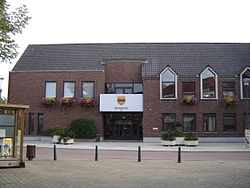
| 👁 Wingene town hall Wingene town hall | |
|
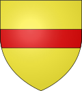
👁 Coat of arms of Wingene Coat of arms | |
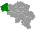
| 👁 Location of Wingene in West Flanders Location of Wingene in West Flanders | |
Interactive map of Wingene | |
Location in Belgium | |
| Coordinates: 51°03′N 03°16′E / 51.050°N 3.267°E / 51.050; 3.267 | |
| Country | Belgium |
| Community | Flemish Community |
| Region | Flemish Region |
| Province | West Flanders |
| Arrondissement | Tielt |
| Government | |
| • Mayor | Lieven Huys (CD&V) |
| • Governing party | CD&V |
| Population (2018-01-01)[1] | |
• Total | 14,243 |
| Postal codes | 8750 |
| NIS code | 37018 |
| Area codes | 051 |
| Website | www.wingene.be |
Wingene (Dutch pronunciation: [ˈʋɪŋənə]; West Flemish: Wiengne; historically: Wynghene) is a municipality located in the Belgian province of West Flanders. The municipality comprises the towns of Wingene proper and Zwevezele. On December 1, 2019, Wingene had a total population of 14,398. The total area is 68.42 km2 which gives a population density of 192 inhabitants per km2.
Gallery
[edit]-
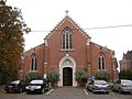
Saint George's church, Wildenburg, Wingene
-
Restored coach house of the former castle of Zwevezele
References
[edit]- ^ "Wettelijke Bevolking per gemeente op 1 januari 2018". Statbel. Retrieved 9 March 2019.
External links
[edit]- 👁 Wikimedia Commons logo
Media related to Wingene at Wikimedia Commons
Retrieved from "https://en.wikipedia.org/w/index.php?title=Wingene&oldid=1311802208"
Hidden categories:
- Pages using gadget WikiMiniAtlas
- Articles with short description
- Short description is different from Wikidata
- Coordinates on Wikidata
- Pages using infobox settlement with potentially too many maps
- Pages with Dutch IPA
- Articles containing West Flemish-language text
- Commons category link from Wikidata
- All stub articles
- Pages using the Kartographer extension