
This article relies largely or entirely on a single source. Relevant discussion may be found on the talk page. Please help improve this article by introducing citations to additional sources. Find sources: "Zsana" – news · newspapers · books · scholar · JSTOR (March 2026) |
Zsana | |
|---|---|
|
👁 Flag of Zsana Flag 👁 Coat of arms of Zsana Coat of arms | |
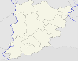
Location of Zsana Zsana (Hungary) Zsana (Europe) | |
| Coordinates: 46°25′N 19°41′E / 46.417°N 19.683°E / 46.417; 19.683 | |
| Country | 👁 Image Hungary |
| County | Bács-Kiskun |
| District | Kiskunhalas |
| Area | |
• Total | 87.94 km2 (33.95 sq mi) |
| Population (2002) | |
• Total | 875 |
| • Density | 10/km2 (26/sq mi) |
| Time zone | UTC+1 (CET) |
| • Summer (DST) | UTC+2 (CEST) |
| Postal code | 6411 |
| Area code | 77 |
Zsana is a village in Bács-Kiskun county,[1] in the Southern Great Plain region of southern Hungary.
Geography
[edit]It covers an area of 87.94 km2 (34 sq mi) and had a population of 875 people in 2002.[citation needed]
History
[edit]On January 24, 1979, a major gas pipeline eruption occurred, known as the 1979 Zsana gas eruption [hu], that took weeks to extinguish.
References
[edit]- ^ "Digitális sötétség közeleg, sok Bács-Kiskun megyei településen megszűnik minden szolgáltatás". Bács-Kiskun vármegyei Online (in Hungarian). 12 September 2025. Retrieved 22 March 2026.
External links
[edit]- Hivatalos honlap (in Hungarian)
- Youtube video of the 1979 gas eruption
Retrieved from "https://en.wikipedia.org/w/index.php?title=Zsana&oldid=1344864756"
Hidden categories:
- Pages using gadget WikiMiniAtlas
- CS1 Hungarian-language sources (hu)
- Articles with short description
- Short description matches Wikidata
- Articles needing additional references from March 2026
- All articles needing additional references
- Use dmy dates from October 2024
- Short description is different from Wikidata
- Coordinates on Wikidata
- All articles with unsourced statements
- Articles with unsourced statements from October 2024
- Articles with Hungarian-language sources (hu)
- All stub articles