
Tuesday, December 17, 2013
GeoTools 10.3 Released
The GeoTools community is happy to bring you the latest GeoTools 10.3 download:
This release is available from our Maven repository for use with your build system.
Only a few fixes this month:
Enjoy,
The GeoTools Community
http://geotools.org
This release is available from our Maven repository for use with your build system.
Only a few fixes this month:
- Assorted rendering fixes for symbols rendered at a maps edge
- Fixes for dash-stroke line offset
- Please see the GeoTools 10.3 Release Notes for additional details.
About GeoTools 10.x Series
Summary of the new features for the GeoTools 10.x series:- Structured grid coverage readers allow raster data sources that publish composite data products to expose individual rasters (ie granules) for processing, while still providing a seamless experience for rendering. The mosaic and NetCDF modules are the first ones to implement these new interfaces.
- Efficient support for multiple coverages in GridCoverageReader provides ad-hoc access to raster formats that publish more that one data product. A image mosaic made of NetCDF granules and single file NetCDF sources are the first implementors of these new capabilities
- A new implementation of Shapefile DataStore (based on ContentDataStore superclass). This upgrade should be seamless for all users using DataStoreFactoryFinder. If you explicitly made use of the ShapefileDataStore or IndexedShapefileDataStore class please check the upgrade instructions.
- The transform module graduated to supported status, providing a seamless way to rename, retype and hide SimpleFeatureSource attributes, as well as creating new ones based on OGC Expression
- Additional OGC modules for the WCS 2.0 and WCS 2.0 EO models as well as adding XML parsers and encoders
- Support for fills made with randomized symbols
- NetCDF has been updated to take advantage of the new coverage API introduced above
- GeoPackage: a sample implementation of the geopackage spec that is currently being developed by the OGC
Enjoy,
The GeoTools Community
http://geotools.org
Labels:
release
Tuesday, November 19, 2013
GeoTools 10.2 released
The GeoTools community is happy to bring you the latest GeoTools 10.2 download:
As an alternative to downloading this release has been deployed to our Maven repository.
This release is made in conjunction with GeoServer 2.4.2 and GeoWebCache 1.5.0.
Notable in this release:
Please see the GeoTools 10.2 Release Notes for additional details.
Enjoy,
The GeoTools Community
http://geotools.org
As an alternative to downloading this release has been deployed to our Maven repository.
This release is made in conjunction with GeoServer 2.4.2 and GeoWebCache 1.5.0.
Notable in this release:
- Fixes in Oracle for mixed geometry collections and SQL Server to handle geometries with Z
- Minor rendering fixes for dashed lines over tiled displays
- GML3 fixes for parsing data with 3D ordinates
- New support for fills made with randomized symbols has been backported to the stable series
Please see the GeoTools 10.2 Release Notes for additional details.
About GeoTools 10.x Series
Summary of the new features for the GeoTools 10.x series:- Structured grid coverage readers allow raster data sources that publish composite data products to expose individual rasters (ie granules) for processing, while still providing a seamless experience for rendering. The mosaic and NetCDF modules are the first ones to implement these new interfaces.
- Efficient support for multiple coverages in GridCoverageReader provides ad-hoc access to raster formats that publish more that one data product. A image mosaic made of NetCDF granules and single file NetCDF sources are the first implementors of these new capabilities
- A new implementation of Shapefile DataStore (based on ContentDataStore superclass). This upgrade should be seamless for all users using DataStoreFactoryFinder. If you explicitly made use of the ShapefileDataStore or IndexedShapefileDataStore class please check the upgrade instructions.
- The transform module graduated to supported status, providing a seamless way to rename, retype and hide SimpleFeatureSource attributes, as well as creating new ones based on OGC Expression
- Additional OGC modules for the WCS 2.0 and WCS 2.0 EO models as well as adding XML parsers and encoders
- NetCDF has been updated to take advantage of the new coverage API introduced above
- GeoPackage: a sample implementation of the geopackage spec that is currently being developed by the OGC
Enjoy,
The GeoTools Community
http://geotools.org
Monday, October 21, 2013
GeoTools 10.1 Released
The GeoTools community is happy to bring you the latest GeoTools 10.1 download:
As an alternative to downloading this release has been deployed to our Maven repository.
This release is made in conjunction with GeoServer 2.4.1 and GeoWebCache 1.5.0.
Please see the GeoTools 10.1 Release Notes for additional details.
Enjoy,
The GeoTools Community
http://geotools.org
As an alternative to downloading this release has been deployed to our Maven repository.
This release is made in conjunction with GeoServer 2.4.1 and GeoWebCache 1.5.0.
Please see the GeoTools 10.1 Release Notes for additional details.
About GeoTools 10.x Series
Summary of the new features for the GeoTools 10.x series:- Structured grid coverage readers allow raster data sources that publish composite data products to expose individual rasters (ie granules) for processing, while still providing a seamless experience for rendering. The mosaic and NetCDF modules are the first ones to implement these new interfaces.
- Efficient support for multiple coverages in GridCoverageReader provides ad-hoc access to raster formats that publish more that one data product. A image mosaic made of NetCDF granules and single file NetCDF sources are the first implementors of these new capabilities
- A new implementation of Shapefile DataStore (based on ContentDataStore superclass). This upgrade should be seamless for all users using DataStoreFactoryFinder. If you explicitly made use of the ShapefileDataStore or IndexedShapefileDataStore class please check the upgrade instructions.
- The transform module graduated to supported status, providing a seamless way to rename, retype and hide SimpleFeatureSource attributes, as well as creating new ones based on OGC Expression
- Additional OGC modules for the WCS 2.0 and WCS 2.0 EO models as well as adding XML parsers and encoders
- NetCDF has been updated to take advantage of the new coverage API introduced above
- GeoPackage: a sample implementation of the geopackage spec that is currently being developed by the OGC
Enjoy,
The GeoTools Community
http://geotools.org
Friday, October 4, 2013
Randomized Fill
Quick cool new feature thanks to the always impressive @geowolf. Andrea is a man of few words and many examples so let me turn you over to his email.
(Check out the original email for the XML code examples, click on the images for larger size).
In this case the randomization is grid based, that is, symbols are not actually
spread out fully randomly, each of them is actually placed at a controlled random
distance from the centers of an invisible grid. Random, but not completely so.
👁 Image
in the pattern that the gridded version did not have.
👁 Image
Here is a fully random one, actually, two, superimposed (see how the seed got changed to avoid getting
the same point distribution twice in a row, which would have made the larger circles just cover the small ones).
👁 Image
As a closing example, the usual topp:states depicted using varying dot density:
Hi,
The randomized fill support discussed some time ago has landed on trunk.
Cheers
Andrea
PS: A note about the params and their default value:Thanks to New South Wales Geological Survey for sponsoring this work.
- random: false
- random-seed: 0 (the seed for the random generator, change its value to get a different distribution at the same density)
- random-symbol-count: 16
- random-tile-size: 256 (the size of the tile... this default is large for small symbols... but ok for larger pictures...)
- random-space-around: 0 (conflict resolution control, similar to labels, < 0 allows for overlap, > 0 pushes symbols further apart)
- random-rotation: false (whether to randomly rotate the symbols as well, or not)
PPS: I'd wish to port it back to the stable series next month if nothing breaks
- random-grid: true (if true the symbols are randomized around the centers of a regular grid, when false it's really fully random)
(Check out the original email for the XML code examples, click on the images for larger size).
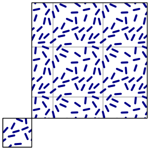
Randomized Slash Symbols
Here is one with randomized "slash" symbols, with a background box fill that helps visualize the "unit" of the random fill, the image that is getting repeated over and over:In this case the randomization is grid based, that is, symbols are not actually
spread out fully randomly, each of them is actually placed at a controlled random
distance from the centers of an invisible grid. Random, but not completely so.
👁 Image
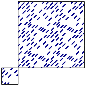
Fully Random without Rotation
Here is one fully random, and without random rotation. As you can see, there are some holesin the pattern that the gridded version did not have.
👁 Image
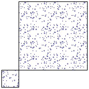
Fully Random
Here is a fully random one, actually, two, superimposed (see how the seed got changed to avoid getting
the same point distribution twice in a row, which would have made the larger circles just cover the small ones).
👁 Image
Theme Example
As a closing example, the usual topp:states depicted using varying dot density:
Friday, September 20, 2013
GeoTools 10.0 Released
The GeoTools community is happy to bring you the latest GeoTools 10.0 download:
As an alternative to downloading this release has been deployed to our maven repository.
This release is made in conjunction with GeoServer 2.4.0 and GeoWebCache 1.5.0. We would to thank everyone who has helped out with testing.
Please see the GeoTools 10.0 Release Notes for additional details.
Enjoy,
The GeoTools Community
http://geotools.org
As an alternative to downloading this release has been deployed to our maven repository.
This release is made in conjunction with GeoServer 2.4.0 and GeoWebCache 1.5.0. We would to thank everyone who has helped out with testing.
Please see the GeoTools 10.0 Release Notes for additional details.
About GeoTools 10.x Series
Summary of the new features for the GeoTools 10.x series:- Structured grid coverage readers allow raster data sources that publish composite data products to expose individual rasters (ie granules) for processing, while still providing a seamless experience for rendering. The mosaic and NetCDF modules are the first ones to implement these new interfaces.
- Efficient support for multiple coverages in GridCoverageReader provides ad-hoc access to raster formats that publish more that one data product. A image mosaic made of NetCDF granules and single file NetCDF sources are the first implementors of these new capabilities
- A new implementation of Shapefile DataStore (based on ContentDataStore superclass). This upgrade should be seamless for all users using DataStoreFactoryFinder. If you explicitly made use of the ShapefileDataStore or IndexedShapefileDataStore class please check the upgrade instructions.
- The transform module graduated to supported status, providing a seamless way to rename, retype and hide SimpleFeatureSource attributes, as well as creating new ones based on OGC Expression
- Additional OGC modules for the WCS 2.0 and WCS 2.0 EO models as well as adding XML parsers and encoders
- NetCDF has been updated to take advantage of the new coverage API introduced above
- GeoPackage: a sample implementation of the geopackage spec that is currently being developed by the OGC
Enjoy,
The GeoTools Community
http://geotools.org
Wednesday, September 18, 2013
GeoTools IP Review Update
There we go, a blog title designed to scare away all but the most dedicated blog readers.
This review was focused on minimising the risk to the OSGeo Foundation by taking on GeoTools as a project. Some risks the foundation is comfortable with, ie listing all known problems, are not necessarly sufficient for all users (who would like to see known problems fixed).
The OSGeo Foundation does not require projects fix all issues in order to give interested parties a chance to fix (or fund) the work.
And if an IP review fails, it fails quietly and we never hear anything again. Indeed if we ask what happened often the organisation conducting the review is forbidden to talk to us about it (for fear of the conversation being taken as advice).
Contrast this with recent developments:
GeoTools Review Status update
After several weeks of email, and a couple days of fixing, I am in the clear to make a GeoTools 9.0-M1 release. Basically the IP review discussion we have been having with LocationTech is complete for GeoTools.
Here are the links:
Only the subset of GeoTools that is used by uDig was reviewed, and there are still many dependencies left to be contacted. But GeoTools is by far the largest stepping stone.
Thanks to all the project leads who will be (or have already been) contacted. We really appreciate you taking the time to answer a few questions.
Wait Didn't OSGeo do this Already?
GeoTools has gone through the OSGeo Incubation Process, and has an extensive Code Provenance Review.This review was focused on minimising the risk to the OSGeo Foundation by taking on GeoTools as a project. Some risks the foundation is comfortable with, ie listing all known problems, are not necessarly sufficient for all users (who would like to see known problems fixed).
The OSGeo Foundation does not require projects fix all issues in order to give interested parties a chance to fix (or fund) the work.
Why this is Cool
So why is this cool? The thing is these intellectual property reviews happen all the time, but behind closed doors. If we are really lucky us open source projects get told about the result, or a few private emails with questions.And if an IP review fails, it fails quietly and we never hear anything again. Indeed if we ask what happened often the organisation conducting the review is forbidden to talk to us about it (for fear of the conversation being taken as advice).
Contrast this with recent developments:
- Google was in position to talk to us about our contributor agreement being unusual. As a result we were able to role out a contribution agreement, OSGeo wide.
- LocationTech IP review is in position to talk with the GeoTools development team, allowing us to answer any questions, and fix any issues that are of concern.
- IBM China was able to ask a few questions via private email which were passed on to the project team as bug reports
So how did we do?
We kind of nailed it, a big thanks to:
- All those who helped dig into the past
(ie sort out where the code comes from). - And Brett Walker for putting together our github pull request policy
(ie looking into the future and sorting out where our code will come from)
The only area where we could do a bit better is with the EMF generated code which currently says:
/**
*
*
*/
It would be nice to configure EMF to fill this in next time we generate stuff. As an example for CSW I ended up with:
/**
*
* (C) 2012, Open Source Geospatial Foundation (OSGeo)
* (C) 2004,2010 Open Geospatial Consortium.
*
* This library is free software; you can redistribute it and/or
* modify it under the terms of the GNU Lesser General Public
* License as published by the Free Software Foundation;
* version 2.1 of the License.
*
* This library is distributed in the hope that it will be useful,
* but WITHOUT ANY WARRANTY; without even the implied warranty of
* MERCHANTABILITY or FITNESS FOR A PARTICULAR PURPOSE. See the GNU
* Lesser General Public License for more details.
*
* $Id$
*
*
*/
Labels:
volunteer
Tuesday, September 3, 2013
GeoTools 10-RC2 released
The GeoTools community is happy to bring you the latest GeoTools 10-RC2 download:
- geotools-10-RC2-bin.zip
- geotools-10-RC2-doc.zip
- geotools-10-RC2-userguide.zip
- geotools-10-RC2-project.zip
This release is made in conjunction with GeoServer 2.4-RC2 containing a few last minute fixes before FOSS4G. We would to thank everyone who has helped out with testing.
Please see the GeoTools 10-RC2 Release Notes for additional details.
If you are working with a projects that uses GeoTools please take a moment to try out GeoTools-10-RC2. This is your chance to check for any regressions or integration issues prior to the stable 10.0 release.
Thanks to Jody Garnett and OpenGeo for issuing this release.
About GeoTools 10.x Series
Summary of the new features for the GeoTools 10.x series:- Structured grid coverage readers allow raster data sources that publish composite data products to expose individual rasters (ie granules) for processing, while still providing a seamless experience for rendering. The mosaic and NetCDF modules are the first ones to implement these new interfaces.
- Efficient support for multiple coverages in GridCoverageReader provides ad-hoc access to raster formats that publish more that one data product. A image mosaic made of NetCDF granules and single file NetCDF sources are the first implementors of these new capabilities
- A new implementation of Shapefile DataStore (based on ContentDataStore superclass). This upgrade should be seamless for all users using DataStoreFactoryFinder. If you explicitly made use of the ShapefileDataStore or IndexedShapefileDataStore class please check the upgrade instructions.
- The transform module graduated to supported status, providing a seamless way to rename, retype and hide SimpleFeatureSource attributes, as well as creating new ones based on OGC Expression
- Additional OGC modules for the WCS 2.0 and WCS 2.0 EO models as well as adding XML parsers and encoders
- NetCDF has been updated to take advantage of the new coverage API introduced above
- GeoPackage: a sample implementation of the geopackage spec that is currently being developed by the OGC
Enjoy,
The GeoTools Community
http://geotools.org
Labels:
release
Wednesday, August 21, 2013
GeoTools 10-RC1 released
The GeoTools community is happy to bring you the latest GeoTools 10-RC1 download:
This release is made in conjunction with GeoServer 2.4-RC1 and it's mostly a bug fix release compared to the latest beta, please see the GeoTools 10-RC1 Release Notes for additional details.
We encourage all projects that make use of GeoTools to update and evaluate GeoTools-10-RC1. This is your best opportunity review incoming changes / integration issues before the project issues a stable 10.0 release.
Thanks to Andrea Aime for issuing this release.
Enjoy,
The GeoTools Community
http://geotools.org
- geotools-10-RC1-bin.zip
- geotools-10-RC1-doc.zip
- geotools-10-RC1-userguide.zip
- geotools-10-RC1-project.zip
This release is made in conjunction with GeoServer 2.4-RC1 and it's mostly a bug fix release compared to the latest beta, please see the GeoTools 10-RC1 Release Notes for additional details.
We encourage all projects that make use of GeoTools to update and evaluate GeoTools-10-RC1. This is your best opportunity review incoming changes / integration issues before the project issues a stable 10.0 release.
Thanks to Andrea Aime for issuing this release.
About GeoTools 10.x Series
Summary of the new features for the GeoTools 10.x series:- Structured grid coverage readers allow raster data sources that publish composite data products to expose individual rasters (ie granules) for processing, while still providing a seamless experience for rendering. The mosaic and NetCDF modules are the first ones to implement these new interfaces.
- Efficient support for multiple coverages in GridCoverageReader provides ad-hoc access to raster formats that publish more that one data product. A image mosaic made of NetCDF granules and single file NetCDF sources are the first implementors of these new capabilities
- A new implementation of Shapefile DataStore (based on ContentDataStore superclass). This upgrade should be seamless for all users using DataStoreFactoryFinder. If you explicitly made use of the ShapefileDataStore or IndexedShapefileDataStore class please check the upgrade instructions.
- The transform module graduated to supported status, providing a seamless way to rename, retype and hide SimpleFeatureSource attributes, as well as creating new ones based on OGC Expression
- Additional OGC modules for the WCS 2.0 and WCS 2.0 EO models as well as adding XML parsers and encoders
- NetCDF has been updated to take advantage of the new coverage API introduced above
- GeoPackage: a sample implementation of the geopackage spec that is currently being developed by the OGC
Enjoy,
The GeoTools Community
http://geotools.org
Sunday, August 18, 2013
GeoTools 9.5 Released
The GeoTools community is pleased to announce the availability of GeoTools 9.5 for download
from source forge:
This is a milestone release made in conjunction with the GeoServer 2.3.5.
Enjoy,
The GeoTools Community
http://geotools.org
- geotools-9.5-project.zip
- geotools-9.5-bin.zip
- geotools-9.5-doc.zip
- geotools-9.5-userguide.zip
- geotools-9.5-project.zip
This is a milestone release made in conjunction with the GeoServer 2.3.5.
About GeoTools 9.5
This release is the last scheduled release for the GeoTools 9.x series.- Upgrade to the ImageIO 1.1.7 library.
- Rasters can now be cropped by region of interest shape (not just a bounding box)
- For more information have a look at the GeoTools 9.5 Release Notes
Enjoy,
The GeoTools Community
http://geotools.org
Labels:
release
Sunday, July 28, 2013
GeoTools 9.4 released
The GeoTools community is pleased to announce the availability of GeoTools 9.4 for download from source forge:
This is a release made in conjunction with the GeoServer 2.3.4.
Finally thanks to Ian Turton and Envitia for putting this release out.
Enjoy,
The GeoTools Community
http://geotools.org
- geotools-9.4-bin.zip
- geotools-9.4-doc.zip
- geotools-9.4-userguide.zip
- geotools-9.4-project.zip/download
This is a release made in conjunction with the GeoServer 2.3.4.
Bugs fixed
- [GEOT-4229] - Joining more than two tables results in mismatching attributes
- [GEOT-4500] - Virtual table metadata does not work for column aliases
- [GEOT-4509] - Additional headers need correction
- [GEOT-4514] - GeoJSON module cannot parse geojson objects with null geometries
Improvement
- [GEOT-4483] - Add support for graphics-margin vendor option for graphic fills as well
- [GEOT-4497] - remove use of proprietary com.sun package classes
- [GEOT-4513] - Upgrade jaitools dependency to 1.3.1
Finally thanks to Ian Turton and Envitia for putting this release out.
Enjoy,
The GeoTools Community
http://geotools.org
Monday, July 22, 2013
GeoTools 10-beta Released
The GeoTools community overjoyed to bring you the latest GeoTools 10-beta download:
This release is made in conjunction with GeoServer 2.4-beta, please see the GeoTools 10-beta Release Notes for additional details.
We would also like to welcome Brett Walker as a new committer for the GeoTools project (who has gathered up a number of last minuet additions for this release).
We encourage all projects that make use of GeoTools to update and evaluate GeoTools-10-beta. This is your best opportunity review incoming changes / integration issues before the project enters the release candidate status. We will be holding a post-beta bug fixing fest later this week and you are invited to take part.
Thanks to Jody Garnett for issuing this release.
Enjoy,
The GeoTools Community
http://geotools.org
- geotools-10-beta-bin.zip
- geotools-10-beta-doc.zip
- geotools-10-beta-userguide.zip
- geotools-10-beta-project.zip/download
This release is made in conjunction with GeoServer 2.4-beta, please see the GeoTools 10-beta Release Notes for additional details.
We would also like to welcome Brett Walker as a new committer for the GeoTools project (who has gathered up a number of last minuet additions for this release).
We encourage all projects that make use of GeoTools to update and evaluate GeoTools-10-beta. This is your best opportunity review incoming changes / integration issues before the project enters the release candidate status. We will be holding a post-beta bug fixing fest later this week and you are invited to take part.
Thanks to Jody Garnett for issuing this release.
About GeoTools 10.x Series
Summary of the new features for the GeoTools 10.x series:- Structured grid coverage readers allow raster data sources that publish composite data products to expose individual rasters (ie granules) for processing, while still providing a seamless experience for rendering. The mosaic and NetCDF modules are the first ones to implement these new interfaces.
- Efficient support for multiple coverages in GridCoverageReader provides ad-hoc access to raster formats that publish more that one data product. A image mosaic made of NetCDF granules and single file NetCDF sources are the first implementors of these new capabilities
- A new implementation of Shapefile DataStore (based on ContentDataStore superclass). This upgrade should be seamless for all users using DataStoreFactoryFinder. If you explicitly made use of the ShapefileDataStore or IndexedShapefileDataStore class please check the upgrade instructions.
- The transform module graduated to supported status, providing a seamless way to rename, retype and hide SimpleFeatureSource attributes, as well as creating new ones based on OGC Expression
- Additional OGC modules for the WCS 2.0 and WCS 2.0 EO models as well as adding XML parsers and encoders
- NetCDF has been updated to take advantage of the new coverage API introduced above
- GeoPackage: a sample implementation of the geopackage spec that is currently being developed by the OGC
Enjoy,
The GeoTools Community
http://geotools.org
Labels:
release
Saturday, June 22, 2013
GeoTools 9.3 Released
GeoTools 9.3 Released
The GeoTools community is pleased to announce the availability of GeoTools 9.3 for download from SourceForge:This release has also been deployed to the OSGeo Maven Repository.
Please see the Release Notes for details. This release is made in conjunction with GeoServer 2.3.3.
A few thanks to the community on the quality assurance front:
- Support for reading files out of a jar. Thanks to Farrukh Najmi for looking into this very tricky issue. This is one of the few patches we have had to accept without a test case as it could only reliably be reproduced using JNLP.
- Christian Mueller continues his excellent work on JDBC support with fixes to DB2 oracle compatibility mode and addressing extent calculation performance
- Mauro Bartolomeoli has been looking at axis order fixes for WFSDataStore, while Andrea Aime has been looking at similar issues with the WMS client, while Christian Mueller allowed for user control axis-order to imagemoasaic-jdbc
Update:
A special call out to users on twitter (@GeoFootballer) and email (Shi Wei Yu, Brett Walker) who helped with the pre-flight testing of the 9.3 release. Any help testing on windows is always welcome, and we were able to fix up a couple of headers.
With that in mind thanks to Jon Skeet for permission to distribute JtsTokenizer on such short notice, and Ben for clarification on the DateUtils header. The GeoTools license page is easier to follow as a result.
If you would like to help test next month check in with the team on #GeoTools or geotools-devel.
This release was brought to you by Jody Garnett from LISAsoft.
About the 9.x Series
Here is a summary of the new features for the GeoTools 9.x series:- Native geometry serialisation has been added for SQL Server.
- Feature Collection Clean up: removed methods that were only applicable for in memory feature collections, combined with a general quality assurance review.
- Vector Grid module is now included as an extension.
- The gt-complex module provides general programming support for complex features.
- Library supports the use of Java 7 try-with-resource syntax.
- PostGIS, Oracle and Property files now provide Partial 3D data support backed by the introduction of ReferenceEnvelope3D.
- WMS 1.3.0 client support now enabled by default.
- OGC models and XML support for WCS 2.0 and OWS 2.0.
- ImageIO-Ext 1.1.6 and JTS 1.13 release
For more information on GeoTools 9.x series
- GeoTools 9.2 Released ( Release Notes )
- GeoTools 9.1 Released ( Release Notes )
- GeoTools 9.0 Released ( Release Notes )
- GeoTools 9.0-RC1 Released ( Release Notes )
- GeoTools 9.0-beta1 Released ( Release Notes )
- GeoTools 9.0-M0 Released ( Release Notes )
Getting Started with GeoTools
GeoTools is an Open Source Geospatial Foundation project helping Java developers work with geospatial data. For a complete list of features please see the project overview included in our documentation.
If you would like to get started with GeoTools a Quickstart is available (covering Eclipse, NetBeans and command line Maven use). Additional tutorials and build instructions are included in the user guide.
GeoTools 9.x is the current stable series with a release scheduled each month. This level of service is part of our six month timed release cycle. We are always interested in volunteers - if you are in position to assist please stop by geotools-devel and lend a hand.
If you are upgrading from a previous version of GeoTools please review the upgrade instructions, as there has been some API changes around the use of FeatureCollection and ReferencedEnvelope.
Thanks for using GeoTools!
Labels:
release
Sunday, May 19, 2013
GeoTools 9.2 Released
GeoTools 9.2 Released
The GeoTools community is pleased to announce the availability of GeoTools 9.2 for download from SourceForge:This release has also been deployed to the OSGeo Maven Repository.
Please see the Release Notes for details. This release is made in conjunction with GeoServer 2.3.2.
In addition to bug fixes:
- The application schema support (app-schema) module now enables joining support by default for data sources that support it; this improvement and many bug fixes by Rini Angreani.
- XML parser support for unsigned numeric bindings has been added by Justin Deoliveira.
- Fixed transformation problems with projections based on Hotine Oblique Mercator (variant B) (for example Swiss CH1903 / LV03)
This release was brought to you by Ben Caradoc-Davies from CSIRO.
About the 9.x Series
Here is a summary of the new features for the GeoTools 9.x series:- Native geometry serialisation has been added for SQL Server.
- Feature Collection Clean up: removed methods that were only applicable for in memory feature collections, combined with a general quality assurance review.
- Vector Grid module is now included as an extension.
- The gt-complex module provides general programming support for complex features.
- Library supports the use of Java 7 try-with-resource syntax.
- PostGIS, Oracle and Property files now provide Partial 3D data support backed by the introduction of ReferenceEnvelope3D.
- WMS 1.3.0 client support now enabled by default.
- OGC models and XML support for WCS 2.0 and OWS 2.0.
- ImageIO-Ext 1.1.6 and JTS 1.13 release
For more information on GeoTools 9.x series
- GeoTools 9.1 Released ( Release Notes )
- GeoTools 9.0 Released (Release Notes )
- GeoTools 9.0-RC1 Released( Release Notes)
- GeoTools 9.0-beta1 Released ( Release Notes )
- GeoTools 9.0-M0 Released ( Release Notes)
Getting Started with GeoTools
GeoTools is an Open Source Geospatial Foundation project helping Java developers work with geospatial data. For a complete list of features please see the project overview included in our documentation.
If you would like to get started with GeoTools a Quickstart is available (covering Eclipse, NetBeans and command line Maven use). Additional tutorials and build instructions are included in the user guide.
GeoTools 9.x is the current stable series with a release scheduled each month. This level of service is part of our six month timed release cycle. We are always interested in volunteers - if you are in position to assist please stop by geotools-devel and lend a hand.
If you are upgrading from a previous version of GeoTools please review theupgrade instructions, as there has been some API changes around the use of FeatureCollection and ReferencedEnvelope.
Thanks for using GeoTools!
Labels:
release
Sunday, April 21, 2013
Annual Report 2012
Key Accomplishments
- The project has switched from subversion to git and is now hosted at GitHub
- GeoTools 8.0 was released
- First major release after a 1.5 year drought
- Amazing release with Java 6, join support, temporal filters, detailed function descriptions
- A total of 10 GeoTools releases made over the course of the year
- The project has switched to a predictable time-boxed release model featuring: six month release cycle and stable release issued each month.
- Extensive build infrastructure improvements with automated release scripts to help us meet this aggressive goal
- Extensive FeatureCollection cleanup and Quality Assurance run slated to land for the next major release
Areas for Improvement
- Attract participation from downstream projects
- Coordinate with downstream projects around release testing
- Contribution License questions have provided some confusion this year
Opportunities to Help
- Volunteers needed to review pull-requests
- The transition to GitHub has certainty paid off, join the team and help us keep up!
Outlook for 2013
- Enjoying active success, and your participation
Labels:
osgeo
Saturday, April 20, 2013
GeoTools 9.1 Released
The GeoTools community is pleased to announce the availability of GeoTools 9.1 for download from sourceforge:
Please see the release notes from the issue tracker for more details. This release is also deployed to our maven repository.
About GeoTools 9.1
This is our first dot release on the 9.1 series and is focused on bug fixes and stability. This release is made in conjunction with GeoServer 2.3.1.
- Headline improvement is support for SQL Server native geometry serialisation. The fix was supplied by Anders Bakkevold and is expected to have a huge impact on performance. This work was sponsored by Norwegian Directorate for Nature Management and performed by Bouvet.
- SQL Server also got a fix to make native paging optional.
- Thanks to Dieter DePaepe for fixing GEOT-2791, addressing a long standing issue working with sparse shapefiles.
- Thanks to Frank Warmerdam for submitting a fix to distance calculations used when testing map projects. Frank was also kind enough to write a blog post covering his experience fixing GeoTools.
- Improvements to Arc parsing in GML were provided by Jira Novak.
- Shane StClair has added UUID mappings to PostGIS.
- Finally thanks to Simone who has addressed an annoying colour space issue on recent windows installations.
Thanks to all our volunteers on GitHub and the dedicated community members reviewing pull requests. A reminder to include a test-case with any proposed fix so we can smoothly review your work.
About the 9.x Series
Here is a summary of the new features for the GeoTools 9.x series:- Native geometry serialisation has been added for SQL Server.
- Feature Collection Clean up: removed methods that were only applicable for in memory feature collections, combined with a general quality assurance review.
- Vector Grid module is now included as an extension.
- The gt-complex module provides general programming support for complex features.
- Library supports the use of Java 7 try-with-resource syntax.
- PostGIS, Oracle and Property files now provide Partial 3D data support backed by the introduction of ReferenceEnvelope3D.
- WMS 1.3.0 client support now enabled by default.
- OGC models and XML support for WCS 2.0 and OWS 2.0.
- ImageIO-Ext 1.1.6 and JTS 1.13 release
For more information on GeoTools 9.x series
- GeoTools 9.0 Released (Release Notes )
- GeoTools 9.0-RC1 Released( Release Notes)
- GeoTools 9.0-beta1 Released ( Release Notes )
- GeoTools 9.0-M0 Released ( Release Notes)
Getting Started with GeoTools
GeoTools is an Open Source Geospatial Foundation project helping Java developers work with geospatial data. For a complete list of features please see the project overview included in our documentation.
If you would like to get started with GeoTools a Quickstart is available (covering Eclipse, NetBeans and command line Maven use). Additional tutorials and build instructions are included in the user guide.
GeoTools 9.x is the current stable series with a release scheduled each month. This level of service is part of our six month timed release cycle. We are always interested in volunteers - if you are in position to assist please stop by geotools-devel and lend a hand.
If you are upgrading from a previous version of GeoTools please review theupgrade instructions, as there has been some API changes around the use of FeatureCollection and ReferencedEnvelope.
Thanks for using GeoTools!
Labels:
release
Subscribe to:
Comments (Atom)