VOOZH about

URL: https://heigit.org/mapswipe/

⇱ MapSwipe – HeiGIT


Skip to content

MapSwipe

Crowdsourcing Global Mapping for Humanitarian Aid

Overview

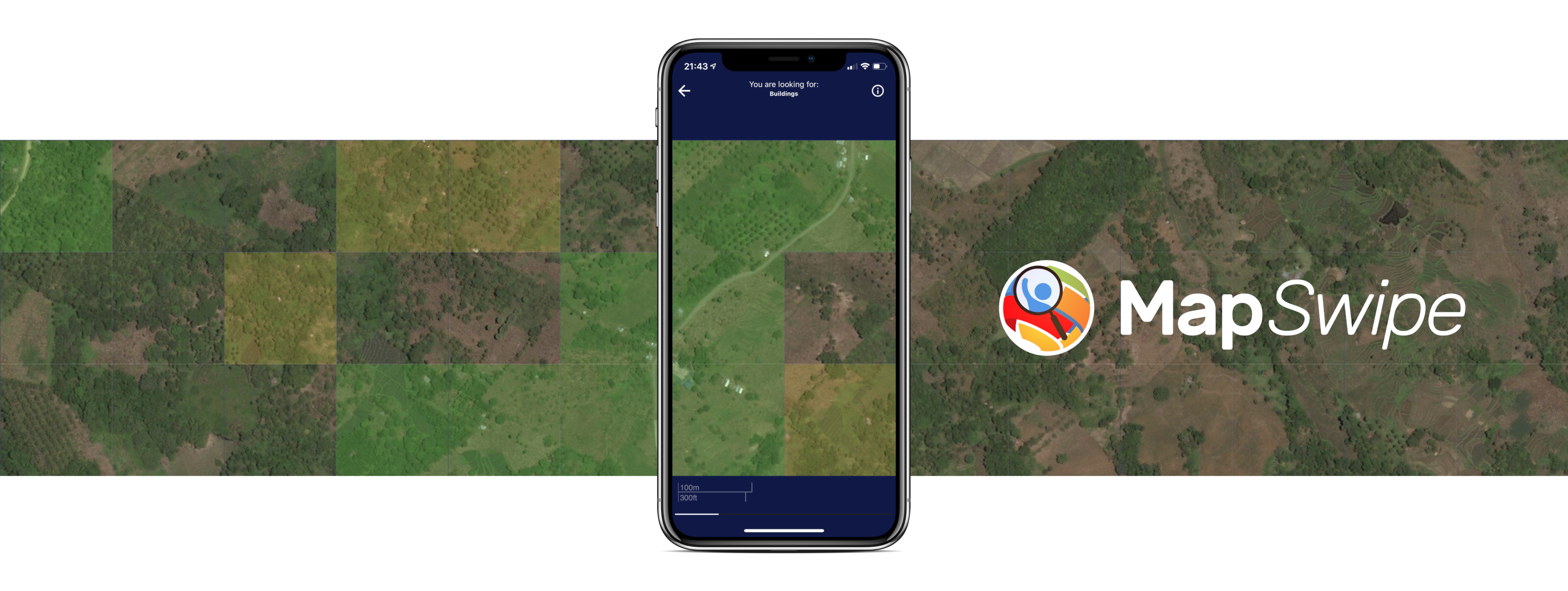
MapSwipe is an open-source mobile and web application designed to enhance global mapping efforts, making them more coordinated and efficient. Launched in 2015, MapSwipe has grown into a community of over 95,000 users who have collectively mapped over 1.3 million square kilometers, supporting critical humanitarian mapping initiatives.

Collaborative Impact Through Partnerships

The project is powered by the collaborative efforts of HeiGIT technologies, the British Red Cross, the American Red Cross, the GIScience Research Group at Heidelberg University, the Humanitarian OpenStreetMap Team, and Médecins Sans Frontières. Built and maintained by a dedicated team of volunteers, MapSwipe leverages HeiGIT’s innovative technology to ensure that mapping data is accurate and accessible.

Crowdsourcing for a Purpose

From the beginning, HeiGIT and the GIScience Research Group have been instrumental in shaping MapSwipe. They designed the crowdsourcing approach that underpins the app, provided the tools needed to manage this global initiative, and ensured the data generated by volunteers is used effectively and promptly. Their contributions help transform volunteer input into actionable data for humanitarian organizations, enabling timely support where it’s needed most. Over the years, we have explored a variety of innovative approaches to expand the app’s functionality, adapting it to meet new challenges and maximize its impact.

Ongoing Projects

April - December 2025

fAIrSwipe

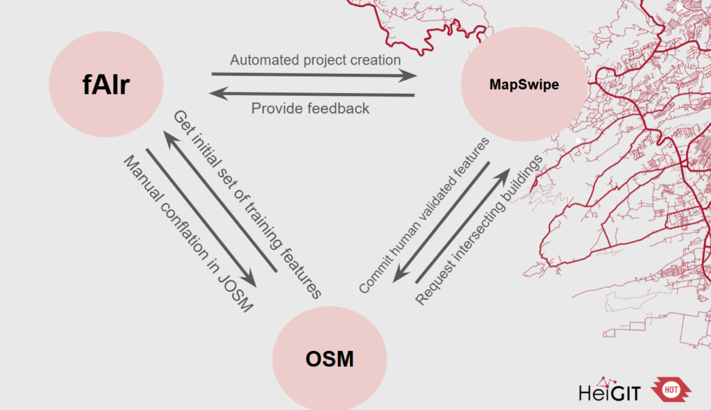
fAIrSwipe aims to combine AI‐generated building predictions from fAIr with crowdsourced validation and conflation workflows in MapSwipe, ultimately pushing high‐confidence conflated map data into OpenStreetMap (OSM).

Completed Projects

Resources

5612809 HeiGIT_MapSwipe 1 apa 5 default 21580 https://heigit.org/wp-content/plugins/zotpress/
%7B%22status%22%3A%22success%22%2C%22updateneeded%22%3Afalse%2C%22instance%22%3Afalse%2C%22meta%22%3A%7B%22request_last%22%3A0%2C%22request_next%22%3A0%2C%22used_cache%22%3Atrue%7D%2C%22data%22%3A%5B%7B%22key%22%3A%22Q2ZWWK89%22%2C%22library%22%3A%7B%22id%22%3A5612809%7D%2C%22meta%22%3A%7B%22lastModifiedByUser%22%3A%7B%22id%22%3A15717726%2C%22username%22%3A%22HeiGITcommunications%22%2C%22name%22%3A%22%22%2C%22links%22%3A%7B%22alternate%22%3A%7B%22href%22%3A%22https%3A%5C%2F%5C%2Fwww.zotero.org%5C%2Fheigitcommunications%22%2C%22type%22%3A%22text%5C%2Fhtml%22%7D%7D%7D%2C%22creatorSummary%22%3A%22Gro%5Cu00df%20et%20al.%22%2C%22parsedDate%22%3A%222023%22%2C%22numChildren%22%3A0%7D%2C%22bib%22%3A%22%26lt%3Bdiv%20class%3D%26quot%3Bcsl-bib-body%26quot%3B%20style%3D%26quot%3Bline-height%3A%202%3B%20padding-left%3A%201em%3B%20text-indent%3A-1em%3B%26quot%3B%26gt%3B%5Cn%20%20%26lt%3Bdiv%20class%3D%26quot%3Bcsl-entry%26quot%3B%26gt%3BGro%26%23xDF%3B%2C%20S.%2C%20Herfort%2C%20B.%2C%20Marx%2C%20S.%2C%20%26amp%3B%20Zipf%2C%20A.%20%282023%29.%20Exploring%20MapSwipe%20as%20a%20Crowdsourcing%20Tool%20for%20%28Rapid%29%20Damage%20Assessment%3A%20The%20Case%20of%20the%202021%20Haiti%20Earthquake.%20%26lt%3Bi%26gt%3BAGILE%3A%20GIScience%20Series%26lt%3B%5C%2Fi%26gt%3B%2C%205.%20%26lt%3Ba%20class%3D%26%23039%3Bzp-DOIURL%26%23039%3B%20href%3D%26%23039%3Bhttps%3A%5C%2F%5C%2Fdoi.org%5C%2F10.5194%5C%2Fagile-giss-4-5-2023%26%23039%3B%26gt%3Bhttps%3A%5C%2F%5C%2Fdoi.org%5C%2F10.5194%5C%2Fagile-giss-4-5-2023%26lt%3B%5C%2Fa%26gt%3B%26lt%3B%5C%2Fdiv%26gt%3B%5Cn%26lt%3B%5C%2Fdiv%26gt%3B%22%2C%22data%22%3A%7B%22itemType%22%3A%22conferencePaper%22%2C%22title%22%3A%22Exploring%20MapSwipe%20as%20a%20Crowdsourcing%20Tool%20for%20%28Rapid%29%20Damage%20Assessment%3A%20The%20Case%20of%20the%202021%20Haiti%20Earthquake%22%2C%22creators%22%3A%5B%7B%22creatorType%22%3A%22author%22%2C%22firstName%22%3A%22Simon%22%2C%22lastName%22%3A%22Gro%5Cu00df%22%7D%2C%7B%22creatorType%22%3A%22author%22%2C%22firstName%22%3A%22Benjamin%22%2C%22lastName%22%3A%22Herfort%22%7D%2C%7B%22creatorType%22%3A%22author%22%2C%22firstName%22%3A%22Sabrina%22%2C%22lastName%22%3A%22Marx%22%7D%2C%7B%22creatorType%22%3A%22author%22%2C%22firstName%22%3A%22Alexander%22%2C%22lastName%22%3A%22Zipf%22%7D%5D%2C%22abstractNote%22%3A%22%22%2C%22proceedingsTitle%22%3A%22AGILE%3A%20GIScience%20Series%22%2C%22conferenceName%22%3A%22%22%2C%22date%22%3A%222023%22%2C%22eventPlace%22%3A%22%22%2C%22DOI%22%3A%2210.5194%5C%2Fagile-giss-4-5-2023%22%2C%22ISBN%22%3A%22%22%2C%22citationKey%22%3A%22%22%2C%22url%22%3A%22%22%2C%22ISSN%22%3A%22%22%2C%22language%22%3A%22%22%2C%22collections%22%3A%5B%223HCGPE8J%22%5D%2C%22dateModified%22%3A%222025-07-10T11%3A00%3A14Z%22%7D%7D%2C%7B%22key%22%3A%22KILRYI4N%22%2C%22library%22%3A%7B%22id%22%3A5612809%7D%2C%22meta%22%3A%7B%22lastModifiedByUser%22%3A%7B%22id%22%3A5396816%2C%22username%22%3A%22chludwig%22%2C%22name%22%3A%22%22%2C%22links%22%3A%7B%22alternate%22%3A%7B%22href%22%3A%22https%3A%5C%2F%5C%2Fwww.zotero.org%5C%2Fchludwig%22%2C%22type%22%3A%22text%5C%2Fhtml%22%7D%7D%7D%2C%22creatorSummary%22%3A%22Ullah%20et%20al.%22%2C%22parsedDate%22%3A%222023-04%22%2C%22numChildren%22%3A0%7D%2C%22bib%22%3A%22%26lt%3Bdiv%20class%3D%26quot%3Bcsl-bib-body%26quot%3B%20style%3D%26quot%3Bline-height%3A%202%3B%20padding-left%3A%201em%3B%20text-indent%3A-1em%3B%26quot%3B%26gt%3B%5Cn%20%20%26lt%3Bdiv%20class%3D%26quot%3Bcsl-entry%26quot%3B%26gt%3BUllah%2C%20T.%2C%20Lautenbach%2C%20S.%2C%20Herfort%2C%20B.%2C%20Reinmuth%2C%20M.%2C%20%26amp%3B%20Schorlemmer%2C%20D.%20%282023%29.%20Assessing%20Completeness%20of%20OpenStreetMap%20Building%20Footprints%20Using%20MapSwipe.%20%26lt%3Bi%26gt%3BISPRS%20International%20Journal%20of%20Geo-Information%26lt%3B%5C%2Fi%26gt%3B%2C%20%26lt%3Bi%26gt%3B12%26lt%3B%5C%2Fi%26gt%3B%284%29%2C%20143.%20%26lt%3Ba%20class%3D%26%23039%3Bzp-DOIURL%26%23039%3B%20href%3D%26%23039%3Bhttps%3A%5C%2F%5C%2Fdoi.org%5C%2F10.3390%5C%2Fijgi12040143%26%23039%3B%26gt%3Bhttps%3A%5C%2F%5C%2Fdoi.org%5C%2F10.3390%5C%2Fijgi12040143%26lt%3B%5C%2Fa%26gt%3B%26lt%3B%5C%2Fdiv%26gt%3B%5Cn%26lt%3B%5C%2Fdiv%26gt%3B%22%2C%22data%22%3A%7B%22itemType%22%3A%22journalArticle%22%2C%22title%22%3A%22Assessing%20Completeness%20of%20OpenStreetMap%20Building%20Footprints%20Using%20MapSwipe%22%2C%22creators%22%3A%5B%7B%22creatorType%22%3A%22author%22%2C%22firstName%22%3A%22Tahira%22%2C%22lastName%22%3A%22Ullah%22%7D%2C%7B%22creatorType%22%3A%22author%22%2C%22firstName%22%3A%22Sven%22%2C%22lastName%22%3A%22Lautenbach%22%7D%2C%7B%22creatorType%22%3A%22author%22%2C%22firstName%22%3A%22Benjamin%22%2C%22lastName%22%3A%22Herfort%22%7D%2C%7B%22creatorType%22%3A%22author%22%2C%22firstName%22%3A%22Marcel%22%2C%22lastName%22%3A%22Reinmuth%22%7D%2C%7B%22creatorType%22%3A%22author%22%2C%22firstName%22%3A%22Danijel%22%2C%22lastName%22%3A%22Schorlemmer%22%7D%5D%2C%22abstractNote%22%3A%22Natural%20hazards%20threaten%20millions%20of%20people%20all%20over%20the%20world.%20To%20address%20this%20risk%2C%20exposure%20and%20vulnerability%20models%20with%20high%20resolution%20data%20are%20essential.%20However%2C%20in%20many%20areas%20of%20the%20world%2C%20exposure%20models%20are%20rather%20coarse%20and%20are%20aggregated%20over%20large%20areas.%20Although%20OpenStreetMap%20%28OSM%29%20offers%20great%20potential%20to%20assess%20risk%20at%20a%20detailed%20building-by-building%20level%2C%20the%20completeness%20of%20OSM%20building%20footprints%20is%20still%20heterogeneous.%20We%20present%20an%20approach%20to%20close%20this%20gap%20by%20means%20of%20crowd-sourcing%20based%20on%20the%20mobile%20app%20MapSwipe%2C%20where%20volunteers%20swipe%20through%20satellite%20images%20of%20a%20region%20collecting%20user%20feedback%20on%20classification%20tasks.%20For%20our%20application%2C%20MapSwipe%20was%20extended%20by%20a%20completeness%20feature%20that%20allows%20to%20classify%20a%20tile%20as%20%5Cu201cno%20building%5Cu201d%2C%20%5Cu201ccomplete%5Cu201d%20or%20%5Cu201cincomplete%5Cu201d.%20To%20assess%20the%20quality%20of%20the%20produced%20data%2C%20the%20completeness%20feature%20was%20applied%20to%20four%20regions.%20The%20MapSwipe-based%20assessment%20was%20compared%20with%20an%20intrinsic%20approach%20to%20quantify%20completeness%20and%20with%20the%20prediction%20of%20an%20existing%20model.%20Our%20results%20show%20that%20the%20crowd-sourced%20approach%20yields%20a%20reasonable%20classification%20performance%20of%20the%20completeness%20of%20OSM%20building%20footprints.%20Results%20showed%20that%20the%20MapSwipe-based%20assessment%20produced%20consistent%20estimates%20for%20the%20case%20study%20regions%20while%20the%20other%20two%20approaches%20showed%20a%20higher%20variability.%20Our%20study%20also%20revealed%20that%20volunteers%20tend%20to%20classify%20nearly%20completely%20mapped%20tiles%20as%20%5Cu201ccomplete%5Cu201d%2C%20especially%20in%20areas%20with%20a%20high%20OSM%20building%20density.%20Another%20factor%20that%20influenced%20the%20classification%20performance%20was%20the%20level%20of%20alignment%20of%20the%20OSM%20layer%20with%20the%20satellite%20imagery.%22%2C%22date%22%3A%222023%5C%2F4%22%2C%22section%22%3A%22%22%2C%22partNumber%22%3A%22%22%2C%22partTitle%22%3A%22%22%2C%22DOI%22%3A%2210.3390%5C%2Fijgi12040143%22%2C%22citationKey%22%3A%22%22%2C%22url%22%3A%22https%3A%5C%2F%5C%2Fwww.mdpi.com%5C%2F2220-9964%5C%2F12%5C%2F4%5C%2F143%22%2C%22PMID%22%3A%22%22%2C%22PMCID%22%3A%22%22%2C%22ISSN%22%3A%222220-9964%22%2C%22language%22%3A%22en%22%2C%22collections%22%3A%5B%5D%2C%22dateModified%22%3A%222025-01-28T09%3A08%3A58Z%22%7D%7D%5D%7D
Groß, S., Herfort, B., Marx, S., & Zipf, A. (2023). Exploring MapSwipe as a Crowdsourcing Tool for (Rapid) Damage Assessment: The Case of the 2021 Haiti Earthquake. AGILE: GIScience Series, 5. https://doi.org/10.5194/agile-giss-4-5-2023
Ullah, T., Lautenbach, S., Herfort, B., Reinmuth, M., & Schorlemmer, D. (2023). Assessing Completeness of OpenStreetMap Building Footprints Using MapSwipe. ISPRS International Journal of Geo-Information, 12(4), 143. https://doi.org/10.3390/ijgi12040143

See all posts

The crowdmapping app MapSwipe now integrates also street-level imagery. This…

No matter where you are or which device you are…

In the aftermath of earthquakes, rapid and accurate assessment of…

Earlier this month, the Association of Geographic Information Laboratories in…

Contact

Oliver Fritz

HeiGIT