
| Donsol | |||
|---|---|---|---|
| Land | 👁 Filippinenes flagg Filippinene | ||
| Status | kommune | ||
| Postnummer | 4715 | ||
| Retningsnummer | 56 | ||
| Areal | 156,2 kvadratkilometer | ||
| Befolkning | 51 781[1] (2024) | ||
| Bef.tetthet | 331,5 innb./kvadratkilometer | ||
| Antall husholdninger | 11 262 | ||
| Språk | Central Bikol, Sorsogon language, tagalog👁 Rediger på Wikidata | ||
| Høydeo.h. | 13 meter | ||
| Nettside | www.donsol.gov.ph/ | ||
| 👁 Kart Donsol 12°54′30″N 123°35′53″Ø | |||
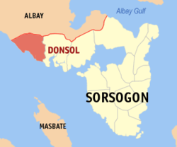
Donsol er en kommune i den filippinske provinsen Sorsogon i landsdelen Luzon.
Barangayer
[rediger | rediger kilde]Kommunen er inndelt i 51 barangayer.[2]
|
|
|
Referanser
[rediger | rediger kilde]- ↑ «2024 Census of Population (POPCEN) Population Counts Declared Official by the President». Filippinenes statistikkbyrå. 17. juli 2025. Besøkt 18. juli 2025.
- ↑ Barangays in Donsol 2018 Philippine Standard Geographic Code (PSGC)
Kilder
[rediger | rediger kilde]- 2018 Philippine Standard Geographic Code (PSGC) Philippine Statistics Authority
Eksterne lenker
[rediger | rediger kilde]- Offisielt nettsted 👁 Rediger på Wikidata
- (en) Donsol – kategori av bilder, video eller lyd på Commons 👁 Rediger på Wikidata