La NASA refuerza Artemis: añade una misión y perfecciona su arquitectura general
article1 month ago
Cryosphere
Observing, understanding, and predicting the ice-covered regions of our planet using NASA assets
Mission
Cryosphere investigates polar ice, including the Antarctic and Greenland ice sheets, polar glaciers, and sea ice in the Arctic and Southern Oceans, with a focus on satellite and airborne observations. Cryosphere also seeks to improve our understanding of processes, advance prediction, and link the cryosphere to the Earth system.
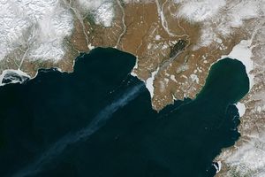
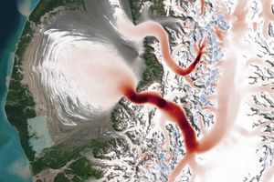
From Alaska’s Saint Elias Mountains to Pakistan’s Karakoram, glaciers speed up and slow down with the seasons.
Article
Overview
Polar ice is a key component of the Earth system, interacting with the biosphere, atmosphere, ocean, and solid earth. It is sensitive to changing atmospheric and oceanic conditions and currently undergoing rapid change. For example, melting ice from the Antarctic and Greenland ice sheets contributes to sea level rise while changes in sea ice impact ocean biology, air-sea exchanges, and the ocean circulation. Furthermore, ice at the poles is highly reflective and changes to the surface area or ice surface reflective properties impact the Earth’s radiation balance. Several feedback mechanisms thus link changes in the polar regions to conditions globally.
Monitoring the cryosphere and to understanding the underlying physical processes that govern its behavior are critical to the US economy and national security. Despite the importance of polar observations, the remote and harsh nature of these regions means in situ measurements are often sparse. NASA Cryosphere thereby uses satellite and airborne based observations to provide large-scale and continuous measurements of the polar regions for the betterment of society.
The Core Science Questions that Drive NASA's Cryosphere Research
How can predictions of glaciers and ice sheet changes be improved?
What are the critical processes related to the cryosphere and global sea levels?
How are ice covered areas changing, especially the frozen oceans in the Arctic and Antarctica, and what are the critical processes related to the Earth system?
Solicited program elements relevant to Cryosphere are publicized through the Research Opportunities in Space and Earth Sciences (ROSES) NASA Research Announcements (NRAs) on the NASA Solicitation and Proposal Integrated Review and Evaluation System (NSPIRES) website. Past, open, and future solicitations can be searched and viewed on NSPIRES.
Cryospheric Sciences (CS) supports basic research into the Earth’s sea- and land-based ice to understand how and why it is changing. Additionally, CS seeks to understand how changes in polar ice will affect global climate, sea level, and the polar environment. Supported studies use space-based, aircraft-based, and other remote sensing techniques to understand the factors controlling the retreat (shrinking) and advance (growth) of the world’s sea- and land-based ice and how polar ice interacts with the ocean, atmosphere, solid Earth, and solar radiation. CS sponsors several polar initiatives designed to encourage an integrated approach to cryospheric science problems, such as the annual West Antarctic Ice Sheet (WAIS) meeting.
NASA Earth Science missions see Earth from space and enable researchers to monitor and understand our home planet. Missions range from instruments onboard the International Space Station (ISS) to Earth-orbiting satellites that span both large and small (i.e., CubeSats) form factors. NASA’s Earth Science missions often have US or other international partnerships and frequently collect data for 10 or more years.
Campaigns use instrumented aircrafts, balloons, ships, and surface networks over land and ocean, to better observe and understand our home planet. Campaigns represent coordinated efforts with intensive observation periods over one or more regions that can last anywhere from weeks to years. These measurements help support missions by providing initial tests of instruments before they are launched to space. Campaigns also provide important measurements to calibrate and validate satellite data in addition to collecting observations in support of related scientific endeavors.
A SpaceX Falcon Heavy rocket carrying the National Oceanic and Atmospheric Administration (NOAA) GOES-U (Geostationary Operational Environmental Satellite U) lifts off from Launch Complex 39A at NASA’s Kennedy Space Center in Florida at 5:26 p.m. EDT on Tuesday, June 25, 2024.
