
Banja Luka Бања Лука | |||||
|---|---|---|---|---|---|
Ceety | |||||
Clockwise frae tap: Panoramic view o Banja Luka, Cathedral o Christ the Saviour, Kastel Fortress on the left bank o the Vrbas River | |||||
👁 Coat of airms o Banja Luka Coat airms | |||||
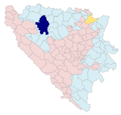
| 👁 Location o Banja Luka athin Republika Srpska an Bosnie an Herzegovinae. Location o Banja Luka athin Republika Srpska an Bosnie an Herzegovinae. | |||||
Location o Banja Luka | |||||
| Coordinates: 44°46′N 17°11′E / 44.767°N 17.183°E / 44.767; 17.183Coordinates: 44°46′N 17°11′E / 44.767°N 17.183°E / 44.767; 17.183 | |||||
| Kintra | 👁 Image Bosnie an Herzegovinae | ||||
| Entity | 👁 Image Republika Srpska | ||||
| Govrenment | |||||
| •Mayor | Dragoljub Davidović (SNSD) | ||||
| Area | |||||
| •Ceety | 1232km2 (476sqmi) | ||||
| Population | |||||
| •Ceety | 238,353 | ||||
| •Density | 243/km2 (630/sqmi) | ||||
| •Urban | 300,000 (approx.) | ||||
| Time zone | UTC+1 (CET) | ||||
| •Summer (DST) | UTC+2 (CEST) | ||||
| Postal code | 78000 | ||||
| Area code(s) | +387 51 | ||||
| Website | www.banjaluka.rs.ba | ||||
Banja Luka or whiles Banjaluka (Serbian Cyrillic: Бања Лука, or Бањалука) is the seicont lairgest ceety in Bosnie an Herzegovinae an the admeenistrative caipital o the Republika Srpska entity. Tradeetionally it haes been the centre o the Bosanska Krajina region, locatit in the north-wastren pairt o the kintra. It is hame o the University o Banja Luka, as well as numerous state an entity institutions o Bosnie an Herzegovinae. The ceety lies on the Vrbas river an is well-kent in the kintras o the umwhile Yugoslavie for bein full o tree-lined avenues, boulevards, gardens, an pairks.[1]
References
[eedit | edit soorce]- ↑ Oficijelna internet prezentacija grada Banjaluke Archived 2008-06-23 at the Wayback Machine
| 👁 Image |
Wikimedia Commons haes media relatit tae Banja Luka. |