
Gomel
Гомель | |
|---|---|
| 👁 Image | |
|
👁 Flag of Gomel Flag 👁 Coat of arms of Gomel Coat of arms | |
| Coordinates: 52°26′43″N 30°59′03″E / 52.44528°N 30.98417°E / 52.44528; 30.98417 | |
| Country | Belarus |
| Subdivision | Homiel |
| Founded | 1142 |
| Government | |
| •Mayor | Viktor Pilipets |
| Area | |
| •City | 121km2 (47sqmi) |
| Population (2004) | |
| •City | 481,197 |
| •Density | 4,258.4/km2 (11,029/sqmi) |
| •Metro | 527,886 |
| Time zone | UTC+2 (EET) |
| •Summer (DST) | UTC+3 (EEST) |
| Area code | +375 232(2) |
| License plate | 3 |
| Website | www.gorod.gomel.by |
.jpg)
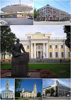
Gomel (also Homiel, Homel) is the administrative center of Gomel Voblast. It is the second-largest city in Belarus. It has a population of 482,652 (2009 census). Gomel is in the southeastern part of the country, on the right bank of Sozh river. It is 302 kilometres (188 miles) to the South-East from Minsk, 534 kilometres (332 miles) to the East from Brest, 171 kilometres (106 miles) to the South from Mogilev, 237 kilometres (147 miles) to the West from Bryansk and 111 kilometres (69 miles) to the North from Chernihiv. The city's area is 121km2.
Other websites
[change | change source]- Homel Region: Epicentre Of Troubles That Bore Celebrities Archived 2015-01-11 at the Wayback Machine
👁 Image
This short article about aplace or feature can be made longer. You can help Wikipedia by adding to it.
This short article about aplace or feature can be made longer. You can help Wikipedia by adding to it.
Retrieved from "https://simple.wikipedia.org/w/index.php?title=Gomel&oldid=9022227"