
| Cornwall (en) Kernow (kw) 👁 Cànbia el vałor in Wikidata | |||
|---|---|---|---|
|
|||
| 👁 Image 👁 Cànbia el vałor in Wikidata | |||
| Pozision | |||
| Stato | Regno Unio | ||
| Nasion costitutiva | Inghiltera | ||
| Rejon d'Inghiltera | Sud Ovest dell'Inghilterra (it) 👁 Traduzi 👁 Cànbia el vałor in Wikidata | ||
| Capitałe | Trurone (it) 👁 Traduzi 👁 Cànbia el vałor in Wikidata | ||
| Popołasion | |||
| Totałe | 575 525 (2020) 👁 Cànbia el vałor in Wikidata | ||
| Densità | 161,56 hab./km² | ||
| Zeografia | |||
| Parte de | Inghiltera e Nazioni celtiche (it) 👁 Traduzi 👁 Cànbia el vałor in Wikidata | ||
| Àrea | 3 562,3326 km²[1] 👁 Cànbia el vałor in Wikidata | ||
| Rente a | |||
| Còdazi de identifegasion | |||
| Catàłogo | Historic Counties Standard: CNW. 👁 Cànbia el vałor in Wikidata | ||
| Còdaze NUTS | UKK30 👁 Cànbia el vałor in Wikidata | ||
| Sito web | cornwall.gov.uk 👁 Cànbia el vałor in Wikidata | ||
|
👁 MusicBrainz: 03d7eb23-c924-4e46-af72-a45f6ee04c8b | |||
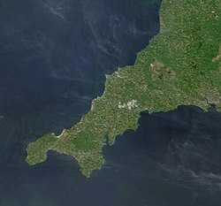
La Cornovaja (cornego Kernow, inglese Cornwall) la xe un dogado ubicà inte l'estremità de la streta penìzoła sud-ocidental de la Gran Bretagna. Indesso la fa parte del sistema ministrativo inglese de le contee secondo el Local Governments Act 1888 nonostante problemi costituzionai col rapporto infra Cornovaja e Inghiltera. Ghe xe vose inte la Cornovaja stessa che le refiuta assolutamente la posision atual de la ministasion odierna, disendo tra l'altro che la sia ilegal par quelo che rivarda sto teritorio "Celtego". Inte ell XX secolo ghe xe stà na renassua del cornego. La Cornovaja la xe una de le sie nasion celteghe (ghe xe stà un debatuo sul so stao costituzional, tanto xe che tanta zente la si riferisce a sta region cofà a un dogado).
El centro ministrativo e l'ugnola city la xe Truro, invence la cavedal storega la xe Bodmin. Comprese le ìzołe Scilly, che le se cata a 45 chilometri da la costa, la Cornovaja la se stende su na superficie de 3 563 chilometri quadrai. La popolasion la supara i 500 000 abitanti. El turismo el xe na parte inportante de l'economia local, anca se la xe la zona pì poara del Regno Unio e che la fornisse el contribuo pì basso a l'economia nazional.
|
.svg)
Bedfordshire ·
Berkshire ·
City of Bristol ·
Buckinghamshire ·
Cambridgeshire ·
Cheshire ·
Cornovaglia ·
Cumbria ·
Derbyshire ·
Devon ·
Dorset ·
Durham ·
East Riding of Yorkshire ·
East Sussex ·
Essex ·
Gloucestershire ·
Grande Londra ·
Greater Manchester ·
Hampshire ·
Herefordshire ·
Hertfordshire ·
Isola di Wight ·
Kent ·
Lancashire ·
Leicestershire ·
Lincolnshire ·
City of London ·
Merseyside ·
Norfolk ·
Northamptonshire ·
Northumberland ·
North Yorkshire ·
Nottinghamshire ·
Oxfordshire ·
Rutland ·
Shropshire ·
Somerset ·
South Yorkshire ·
Staffordshire ·
Suffolk ·
Surrey ·
Tyne and Wear ·
Warwickshire ·
West Midlands ·
West Sussex ·
West Yorkshire ·
Wiltshire ·
Worcestershire
Contee del Lieutenancies Act 1997
- 👁 Cołaborea a Wikimedia Commons
Wikimedia Commons el detien imàjini o altri file so Cornovagia - 👁 Scholia
Scholia el detien schemi gràfeghi so Cornovaja
| Controło de autorità | VIAF (EN) 143316992 · LCCN (EN) n80106711 · GND (DE) 4010579-9 · WorldCat Identities (EN) n80-106711 |
|---|
- ↑ URL de refarensa: http://ons.maps.arcgis.com/home/item.html?id=a79de233ad254a6d9f76298e666abb2b.
- Voze co argominti formatnum no numèreghi
- Voze co targhete de Wikidata sensa tradusion
- P18 lexesta da Wikidata
- P41 difarente in Wikidata
- P856 difarente in Wikidata
- P2046 difarente in Wikidata
- Pàjine che łe dòpara el modeło Interprojeto
- Voxe co còdaxe VIAF
- Voxe co còdaxe LCCN
- Voxe co còdaxe GND
- Voxe no biogràfeghe co còdaxi de controło de autorità
- Pàjine co mape