 |
VOOZH | about |
|
VOOZH | about |
| Country | Iran |
| Volcanic Region | Central Asia Volcanic Province |
| Landform | Volc Type | Composite | Stratovolcano |
| Last Known Eruption | Pleistocene |
| Coordinates | 28.6°N, 61.13°E |
| Elevation | 3,940 m (12,927 ft) |
| Volcano Number | 232050 |
|
👁 Google Earth icon Google Earth Placemark with Features | |
|
👁 Citation icon Cite Volcano Profile | |
The Global Volcanism Program has no Weekly Volcanic Activity Reports available for Taftan.
October 2003 visit found passive degassing; petrography of andesite lava sample
When visited in October 2003, Taftan's behavior was similar to that reported in July 1999 (BGVN 24:10), consisting of a fumarolic zone on the SE cone's W side, ~ 10 m2 in area, emitting steam and SO2 gas, and depositing sulfur. Degassing was clearly visible from the refuge at 3,250 m elevation. A mixture of sulfur and clay derived from highly altered lavas gave a snowy appearance to the summit. This snowy appearance was also noted in July 1999 (BGVN 24:10). Close to the refuge, a warm acid spring generated deep yellow deposits along the ditch down the valley for more than 1 km. A chemical analysis showed that the deposits were predominantly iron salts.
A surface lava sample, taken on 30 October 2003 from just below the refuge on the volcano's W slopes, was judged to be relatively young. George Morris analyzed the sample by X-ray fluorescence spectroscopy (XRF) and described the sample as andesite. This was the first known chemical analysis for Taftan rocks. In addition to the sampled lava flow, thick deposits of ignimbrite appeared in the walls of a deep gorge followed by the trail ascending to the refuge (at ~ 2,500 m elevation). It looked fresh and was judged to be Holocene in age.
Petrography of the lava sample. The sample is phenocryst rich (by volume, ~ 40-50% phenocrysts) in a microcrystalline to cryptocrystalline groundmass. Plagioclase is the predominant phenocryst phase (30-40%) with hornblende (< 5%), pyroxene (< 1%), opaque Fe-Ti oxide phases (< 1%), and trace amounts of biotite. Microxenoliths (1-3 mm in size) were observed, contributing < 2% volume to the whole rock.
Plagioclase phenocrysts invariably show complex zoning, but can be roughly divided into four groups. Euhedral plagioclase (0.5-1 mm long) show fine oscillatory zoning as well as internal dissolution and overgrowth surfaces. They are invariably euhedral but show no sieve-textured zones or dissolution channeling. Sieve-texture mantled plagioclase (0.5-5 mm long) can either have an un-zoned anhedral or an oscillatory zoned core. This is mantled with a zone of fine sieve-textured plagioclase of variable width, then overgrown by an un-sieved rim that may be oscillatory zoned. Inclusion-rich zones were observed running parallel to the sieve-textured zones within the cores of larger phenocrysts. Sieve-cored plagioclase (0.3-1 mm long) contain a completely sieve-textured core overgrown (normally) with an oscillatory zoned rim. These are generally smaller than the sieve-texture mantled plagioclase; however, the thicker un-sieved rims suggest that they form a distinct group rather than being a smaller version of the above. Small euhedral lath shaped plagioclase (< 0.3 mm) are common in the groundmass.
Hornblende occurs as lozenge-shaped crystals 0.2-1.5 mm long. These are invariably rimmed by thick reaction zones dominated by opaque oxides. These reaction zones can sometimes completely replace the original phenocryst.
Rare euhedral crystals of clinopyroxene were observed as phenocrysts. Similar pyroxenes were observed both in clots (with plagioclase) and in microxenoliths. Opaque oxide phases were observed as euhedral to anhedral phenocrysts 0.2-0.3 mm in diameter but account for less than 1% of the whole rock. Trace amounts of biotite were also observed; similar biotite was seen in microxenoliths. Most microphenocrysts contained a microcrystalline mass dominated by opaque oxides. Where less altered examples survive, the mineralogy is dominated by subhedral plagioclase and euhedral clinopyroxene, the pyroxene often partially altered to biotite and oxide phases. Crystal faces on feldspar in contact with the groundmass show sieve-textured reaction mantles, which is absent on crystal faces internal to the microxenoliths.
Interpretation. The phenocryst assemblage of the lava sample suggests multiple phenocryst sources and disequilibrium between mineral phases and groundmass, typical of stratovolcanoes. The correspondence of some phenocryst phases with mineral phases in microxenoliths suggest that at least some of the phenocrysts were inherited during the assimilation of country rock, while the oscillatory zoning, sieve-textured cores and mantles, and multiple dissolution surfaces in feldspars indicates that other phenocrysts have undergone long and complex magmatic histories.
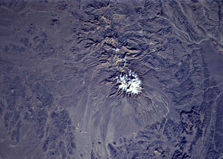
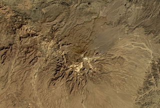
Setting and summit elevation. Taftan is in eastern Iran, 100 km SSE of the city of Zahedan and 50 km W of the Pakistan border. Several necks, representing erosional remnants of cinder cones, rise from the plain W from Taftan, as well as a second stratovolcano, Buzman (~ 3,500 m summit elevation), which remains largely unknown.
The summit elevation is listed in the Catalog of Active Volcanoes of the World (Gansser, 1964) as 4,050 m. Jean Sesiano found (presumably more current) Iranian maps with the volcanically active SE summit shown as 3,940 m, and the dissected NW summit, as 3,840 m.
Reference. Gansser, A., 1964, Catalog of the Active Volcanoes and Solfatara Fields of Iran; Rome, IAVCEI, part XVII-Appendix, p. 1-20.
Information Contacts: Jean Sesiano and George Morris, Earth Sciences Section, Mineralogy Dept, University of Geneva, 13 rue des Maraîchers, 1205 Genève, Switzerland
The Global Volcanism Program has no Weekly Reports available for Taftan.
Reports are organized chronologically and indexed below by Month/Year (Publication Volume:Number), and include a one-line summary. Click on the index link or scroll down to read the reports.
04/1993 (BGVN 18:04) Lava flow reported; no previous historical eruptions known
10/1999 (BGVN 24:10) Visitors note mineral springs and fumaroles
10/2004 (BGVN 29:10) October 2003 visit found passive degassing; petrography of andesite lava sample
Information is preliminary and subject to change. All times are local (unless otherwise noted)
Lava flow reported; no previous historical eruptions known
An eruption that sent a lava flow ~60 m downslope was reported on 25 April by the Islamic Republic News Agency. No additional information about the timing or location of the activity was available. There was apparently no immediate danger to the local population.
Information Contacts: AP; Reuters.
Visitors note mineral springs and fumaroles
In response to reported fumarolic activity near the summit, a group from the Societe de Volcanologie Geneve ascended the summit on 27 July 1999. The activity focused at a solfatara 1.5 x 5 m in size with several openings emitting SO2-rich vapor plumes. The surrounding area resembled a snowcap despite consisting entirely of sulfur and clay.
During the ascent clear water was seen at 3,220 m elevation almost 800 m below the summit. At about the 3,240 m elevation, a spring was discovered pouring from the flank of the volcano. The water in the spring reached a temperature of nearly 30°C and a pH of 1. The spring water created a white-yellowish deposit which darkened as it dried. The dried deposits were colored sharp yellow to dark orange. Despite their color, these deposits were not formed from sulfur, but rather from iron chlorides. When redissolved back in water, a colorless solution resulted.
Information Contacts: D. Zurcher and R. Haubrichs, Societe de Volcanologie Geneve (SVG), C.P. 6423, CH-1211, Geneve 6, Switzerland (Bulletin de la SVG, October 1999, p. 6 (in French)).
October 2003 visit found passive degassing; petrography of andesite lava sample
When visited in October 2003, Taftan's behavior was similar to that reported in July 1999 (BGVN 24:10), consisting of a fumarolic zone on the SE cone's W side, ~ 10 m2 in area, emitting steam and SO2 gas, and depositing sulfur. Degassing was clearly visible from the refuge at 3,250 m elevation. A mixture of sulfur and clay derived from highly altered lavas gave a snowy appearance to the summit. This snowy appearance was also noted in July 1999 (BGVN 24:10). Close to the refuge, a warm acid spring generated deep yellow deposits along the ditch down the valley for more than 1 km. A chemical analysis showed that the deposits were predominantly iron salts.
A surface lava sample, taken on 30 October 2003 from just below the refuge on the volcano's W slopes, was judged to be relatively young. George Morris analyzed the sample by X-ray fluorescence spectroscopy (XRF) and described the sample as andesite. This was the first known chemical analysis for Taftan rocks. In addition to the sampled lava flow, thick deposits of ignimbrite appeared in the walls of a deep gorge followed by the trail ascending to the refuge (at ~ 2,500 m elevation). It looked fresh and was judged to be Holocene in age.
Petrography of the lava sample. The sample is phenocryst rich (by volume, ~ 40-50% phenocrysts) in a microcrystalline to cryptocrystalline groundmass. Plagioclase is the predominant phenocryst phase (30-40%) with hornblende (< 5%), pyroxene (< 1%), opaque Fe-Ti oxide phases (< 1%), and trace amounts of biotite. Microxenoliths (1-3 mm in size) were observed, contributing < 2% volume to the whole rock.
Plagioclase phenocrysts invariably show complex zoning, but can be roughly divided into four groups. Euhedral plagioclase (0.5-1 mm long) show fine oscillatory zoning as well as internal dissolution and overgrowth surfaces. They are invariably euhedral but show no sieve-textured zones or dissolution channeling. Sieve-texture mantled plagioclase (0.5-5 mm long) can either have an un-zoned anhedral or an oscillatory zoned core. This is mantled with a zone of fine sieve-textured plagioclase of variable width, then overgrown by an un-sieved rim that may be oscillatory zoned. Inclusion-rich zones were observed running parallel to the sieve-textured zones within the cores of larger phenocrysts. Sieve-cored plagioclase (0.3-1 mm long) contain a completely sieve-textured core overgrown (normally) with an oscillatory zoned rim. These are generally smaller than the sieve-texture mantled plagioclase; however, the thicker un-sieved rims suggest that they form a distinct group rather than being a smaller version of the above. Small euhedral lath shaped plagioclase (< 0.3 mm) are common in the groundmass.
Hornblende occurs as lozenge-shaped crystals 0.2-1.5 mm long. These are invariably rimmed by thick reaction zones dominated by opaque oxides. These reaction zones can sometimes completely replace the original phenocryst.
Rare euhedral crystals of clinopyroxene were observed as phenocrysts. Similar pyroxenes were observed both in clots (with plagioclase) and in microxenoliths. Opaque oxide phases were observed as euhedral to anhedral phenocrysts 0.2-0.3 mm in diameter but account for less than 1% of the whole rock. Trace amounts of biotite were also observed; similar biotite was seen in microxenoliths. Most microphenocrysts contained a microcrystalline mass dominated by opaque oxides. Where less altered examples survive, the mineralogy is dominated by subhedral plagioclase and euhedral clinopyroxene, the pyroxene often partially altered to biotite and oxide phases. Crystal faces on feldspar in contact with the groundmass show sieve-textured reaction mantles, which is absent on crystal faces internal to the microxenoliths.
Interpretation. The phenocryst assemblage of the lava sample suggests multiple phenocryst sources and disequilibrium between mineral phases and groundmass, typical of stratovolcanoes. The correspondence of some phenocryst phases with mineral phases in microxenoliths suggest that at least some of the phenocrysts were inherited during the assimilation of country rock, while the oscillatory zoning, sieve-textured cores and mantles, and multiple dissolution surfaces in feldspars indicates that other phenocrysts have undergone long and complex magmatic histories.
Setting and summit elevation. Taftan is in eastern Iran, 100 km SSE of the city of Zahedan and 50 km W of the Pakistan border. Several necks, representing erosional remnants of cinder cones, rise from the plain W from Taftan, as well as a second stratovolcano, Buzman (~ 3,500 m summit elevation), which remains largely unknown.
The summit elevation is listed in the Catalog of Active Volcanoes of the World (Gansser, 1964) as 4,050 m. Jean Sesiano found (presumably more current) Iranian maps with the volcanically active SE summit shown as 3,940 m, and the dissected NW summit, as 3,840 m.
Reference. Gansser, A., 1964, Catalog of the Active Volcanoes and Solfatara Fields of Iran; Rome, IAVCEI, part XVII-Appendix, p. 1-20.
Information Contacts: Jean Sesiano and George Morris, Earth Sciences Section, Mineralogy Dept, University of Geneva, 13 rue des Maraîchers, 1205 Genève, Switzerland
|
|
||||||||||||||||||||||||||
There is data available for 0 confirmed eruptive period.
[ 1993 Apr 25 ] Uncertain Eruption
| Episode 1 | Eruption (Explosive / Effusive) | ||||||||||||||||
|---|---|---|---|---|---|---|---|---|---|---|---|---|---|---|---|---|
| 1993 Apr 25 - Unknown | Evidence from Unknown | |||||||||||||||
|
List of 2 Events for Episode 1
|
||||||||||||||||
[ 1902 Jan 16 ± 15 days ] Uncertain Eruption
| Episode 1 | Eruption (Explosive / Effusive) | ||||||||||||||||
|---|---|---|---|---|---|---|---|---|---|---|---|---|---|---|---|---|
| 1902 Jan 16 ± 15 days - Unknown | Evidence from Unknown | |||||||||||||||
|
List of 2 Events for Episode 1
|
||||||||||||||||
This compilation of synonyms and subsidiary features may not be comprehensive. Features are organized into four major categories: Cones, Craters, Domes, and Thermal Features. Synonyms of features appear indented below the primary name. In some cases additional feature type, elevation, or location details are provided.
Synonyms |
| Kuh-e Taftan | Koh-i Taftan | Kuh-i-Daftan | Daftan |
There are no samples for Taftan in the Smithsonian's NMNH Department of Mineral Sciences Rock and Ore collection.
| Copernicus Browser | The Copernicus Browser replaced the Sentinel Hub Playground browser in 2023, to provide access to Earth observation archives from the Copernicus Data Space Ecosystem, the main distribution platform for data from the EU Copernicus missions. |
|
WOVOdat
Single Volcano View Temporal Evolution of Unrest Side by Side Volcanoes |
WOVOdat is a database of volcanic unrest; instrumentally and visually recorded changes in seismicity, ground deformation, gas emission, and other parameters from their normal baselines. It is sponsored by the World Organization of Volcano Observatories (WOVO) and presently hosted at the Earth Observatory of Singapore.
GVMID Data on Volcano Monitoring Infrastructure The Global Volcano Monitoring Infrastructure Database GVMID, is aimed at documenting and improving capabilities of volcano monitoring from the ground and space. GVMID should provide a snapshot and baseline view of the techniques and instrumentation that are in place at various volcanoes, which can be use by volcano observatories as reference to setup new monitoring system or improving networks at a specific volcano. These data will allow identification of what monitoring gaps exist, which can be then targeted by remote sensing infrastructure and future instrument deployments. |
| EarthScope Consortium SAGE seismic stations/networks | EarthScope Consortium operates the NSF Geodetic Facility for the Advancement of Geoscience (GAGE) and NSF Seismological Facility for the Advancement of Geoscience (SAGE). The linked map shows the location of seismic stations from all available networks (permanent or temporary) within a radius of 0.18° (about 20 km at mid-latitudes) from the given location of Taftan. Users can customize a variety of filters and options in the left panel. Note that if there are no stations are known the map will default to show the entire world with a "No data matched request" error notice. |
| Large Eruptions of Taftan | Information about large Quaternary eruptions (VEI >= 4) is cataloged in the Large Magnitude Explosive Volcanic Eruptions (LaMEVE) database of the Volcano Global Risk Identification and Analysis Project (VOGRIPA). |
| EarthChem | EarthChem develops and maintains databases, software, and services that support the preservation, discovery, access and analysis of geochemical data, and facilitate their integration with the broad array of other available earth science parameters. EarthChem is operated by a joint team of disciplinary scientists, data scientists, data managers and information technology developers who are part of the NSF-funded data facility Integrated Earth Data Applications (IEDA). IEDA is a collaborative effort of EarthChem and the Marine Geoscience Data System (MGDS). |