 |
VOOZH | about |
|
VOOZH | about |
| 👁 Logo. Feature: Destination restriction indications |
| Error creating thumbnail: |
| Description |
| Tagging scheme for indications, placed on destination signs, prewarning about remote access restrictions or recommendations (approved) |
| Tags |
|
In this tagging scheme, restriction is meant for any access tagging, including recommandations, i.e. designated, unless otherwise stated. |
Access restrictions are tagged on highways with specific tags on the specific highway segments subject to restrictions. For instance, a highway forbidden to hazmat vehicles would be tagged hazmat=no. This kind of tags explicitly links the access restrictions to a specific highway, and is typically enough for data consumers; for instance, a route planner encountering a road tagged hazmat=no would try to check if the planned route is to be used by a hazmat vehicle and, if so, could prepare a new route avoiding this highway.
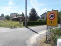
In order to provide advance warning of such restrictions, the destination signs may show indications warning the drivers of restrictions they will likely encounter if they follow the pointed highway to reach a specific destination[1]. Say that a driver wants to go to Ballaison and encounters the sign on the right picture. This driver would then have to choose on which highway to turn according to the characteristics of the driven vehicle:
These indications, placed on destination signs, advise about incoming restrictions on the signed route to the destination. The advised restrictions may be placed immediately after the junction, sometimes they are placed further away.
These pictograms or text labels typically don't enforce the restriction itself, rather being a prewarning, but may enforce it according to local regulations. This tagging scheme is only about the modelling of the restriction on the destination sign, and does not model its enforcement; the restriction enforcement must then, as usual, be tagged on the highway=* object (hazmat=no or maxheight=3.5, for instance).
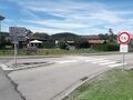
This may be counterintuitive, because such signs often look like standard restriction signs, but the schema on the right should explain why such indications typically don't enforce restrictions. According to this schema, Ballaison is reachable through two main routes:
Whatever the way you decide to follow and the kind of vehicle you drive, there are other routes to Ballaison than the signed ones. The destination signs are designed to allow drivers to simply find the shortest/quickest routes for a simple reason: it is what the typical driver would look for.
That being said, according to your vehicle, the time you have to reach Ballaison and whether you care about high fuel prices or not, you may simply express your imagination and enjoy the landscapes by choosing another route, say the blue-dashed one, which is neither the quickest nor the shortest route, and still reach Ballaison.
There may be other situations showing that such indications typically don't enforce restrictions:
In the end, destination restriction indications should be treated by mappers and data consumers as mere symbols: even if a by-passer would treat them as legit restriction advance warning or detour route recommendations, they may be used for other meanings and data users must not treat them for anything else than destination sign displays.
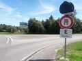
This tagging scheme is only for restriction indications which are part of a destination sign. Here are examples of restriction signs which are not eligible to the present tagging scheme, with explanations about why they are not eligible.
It may happen that a restriction indication does not have a recognized, documented human-readable tagging. According to the any tags you like policy, you may invent a new tag which follows the present tagging scheme. That being said, this tagging scheme assumes that the restriction represented by the indication already has an established tagging for highway=* objects.
Therefore, you really should first discuss with the OSM community about how to map, on highway=* objects, this restriction, before mapping the corresponding destination indication.
The following tags are to be used on 👁 way
ways, as with destination:*=* tags. Their usage on 👁 relation
destination_sign relations has not been evaluated, but no problem is expected to arise should they be used as is on such relations.
| A TL;DR is available at the end of this section. |
Many of the destination restriction indications are identical or similar to existing highway restrictions: maximum width, maximum height, maximum weight… To ease the modelling of destination restrictions indications, the existing restriction tagging will be reused as far as possible.
Because tags such as destination:foot=* or destination:bicycle=* are already used to map destination signs meant only to some modes of transport, destination:access:*=* prefix is to be used instead.
| Restriction | Tagging |
|---|---|
| Destination which is displayed as forbidden for vehicles taller than 3.3 meters | destination:access:maxheight=3.3
|
| Destination which is displayed as forbidden for hazmat vehicles | destination:access:hazmat=no
|
| Destination which is recommended for goods vehicles | destination:access:goods=designated
|
| Destination which is recommended for goods vehicles longer than 9 meters | destination:access:goods:conditional=designated @ (length > 9)
|
Any access tags (bicycle=*, foot=*, moped=*…) used on highway=* can be used as destination prefix following this pattern.
| |
The tagging scheme for such indications is similar to the tagging scheme of destination properties (destination:colour=*, destination:symbol=*…):
none value is a synonym of an empty value), one value per destination=* value;destination=* values, these values are evaluated as applying to the respective destination=* values:
destination=foo;bar + destination:access:hazmat=no;, the destination foo is understood as having a hazmat=no restriction indication, and the bar destination is understood as having no hazmat=* restriction indication;In some countries such as the United Kingdom, the destination restriction indications often come with a distance plate indicating the distance from the junction at which the restriction will be encountered, such as the hereby example.
In order to tag such distance plates, if present: for a given destination:access:X=* restriction indication, the distance plate is to be tagged as destination:access:X:distance=*, with unit if necessary. The example destination sign would therefore be tagged as follows:
destination=Harcourtdestination:ref=A 543destination:colour=greendestination:access:maxheight=4.4destination:access:maxheight:distance=1.0 mi.Local OSM communities should publish, on the OSM wiki, a table of possible destination restriction indications (preferably in SVG format for indications displayed with pictograms), with their corresponding tagging. Mapping most destination restriction indications should be simple enough (as the tagging scheme is mostly self-describing) to not need such a table, but it would be very helpful for renderers willing to manage local destination restriction indications, in addition of being a reference for contributors.
Particularly, some restriction indications may necessitate the use of conditional restriction syntax, which can be tricky and offer multiple valid possibilities to map the indication. In such cases, it is especially important that local OSM communities:
Here are the already agreed destination restriction indication tagging per country:
Take for example a destination sign for Toul, with two restriction indications, the first saying that Toul should not be reachable by vehicles taller than 3.5 meters, and the second saying that it also should not be reachable by hazmat vehicles. The present tagging scheme would give the following tagging:
destination=Touldestination:ref=N 4destination:colour=greendestination:access:hazmat=nodestination:access:maxheight=3.5The question for a correct rendering of the destination sign with its restriction indications would be: in which order are they displayed on the Toul destination sign?
For such cases, use already established destination:symbol=* key and its subkeys, by inserting in its values the list of destination restriction suffixes.
For the above example, the tagging would then be:
destination=Touldestination:ref=N 4destination:colour=greendestination:access:hazmat=nodestination:access:maxheight=3.5destination:symbol=access:maxheight,access:hazmatIf, for a given destination, the sign has both restriction indications and standard symbols such as motorway or info, the value of destination:symbol=* reflects the respective order of restriction indications and standard symbols:
destination:ref=N 4destination:colour=blue;blue;green;greendestination=Nancy;Lunéville;Blâmont;Sarrebourgdestination:access:hazmat:water=no;no;;destination:symbol=motorway,access:hazmat:water;motorway,access:hazmat:water;;In some areas, as in North America, destination:symbol=* is understood as a mere unordered list of the symbols displayed on the destination sign, and may not tell to which destination the symbols refers. In this case, you may safely ignore adding the destination restriction indications in destination:symbol=*: the destination sign renderer is then left on its own to render the respective order of symbols and restriction indications according to local regulations.
In other areas, destination:symbol=* values are ordered, and these semicolon-separated values relate to the respective semicolon-separated destinations. In these areas, destination:symbol=* may only be omitted when there is only one restriction indication and no standard symbol. It should be used when there are at least two indications/symbols, whether restriction indications or standard symbols, to give the order in which they are placed on the destination sign. Without using destination:symbol=* in such cases, the destination sign renderer is left on its own to try rendering the correct order of symbols and restriction indications; if this order is arbitrary (i.e. there is no regulation about it), the destination sign renderer will likely fail to correctly order symbols and restriction indications.
| Tag | Meaning |
|---|---|
destination:access:maxheight=*
|
Destination restriction indication prewarning about a maximum height |
destination:access:hgv=*
|
Destination restriction indication prewarning about restriction for HGV |
destination:access:hazmat=*
|
Destination restriction indication prewarning about restriction for hazmat vehicles |
| Destination restriction indication prewarning about restriction for pedestrians | |
| Destination restriction indication, necessitating the use of conditional access restrictions. | |
Open-ended list: any access tag (bicycle=*, goods=*, moped=*…) used on highway=* elements can be used as destination:*=* key suffix following this pattern.
| |
destination:access:{restriction}:distance=*
|
Distance at which the restriction is displayed to be on the destination sign |
destination:symbol=*
|
Relative order of destination restriction indication and other destination symbols, if relevant. |
|
To limit the complexity of the examples, no per-lane destination tagging is shown; only destination-related tags are given for the examples, and they are assumed as one-way highways. This prevents burdening the examples with |
| Signs | Tagging | Notes |
|---|---|---|
| File:Panneau centre ville interdit plus de 3,5 tonnes par essieu.jpg
France
|
On the 👁 way way branching off the junction to the right:
|
This is one of the many cases where the destination pictogram is contextual, and may change according to the exact restriction; here, the destination:access:maxaxleload=* may have any value displayed by the max axle load destination pictogram.
As there is no other indication/symbol than |
| 👁 Image United States of America
|
On the 👁 way way branching off the junction to the right:
|
Note the use of text for the restriction indication, typical of MUTCD-compliant signage; in Vienna Convention-compliant signage, as in Europe, pictograms are preferred. |
| File:Knuten skilt.JPG
Norway
|
On the 👁 way way branching ahead off the junction:
|
The use of destination:symbol=*, besides modelling the use of the historic symbol, gives the renderer the order in which destination:access:maxheight=* and historic pictogram are to be rendered.
|
| 👁 Image Sweden
|
On the 👁 way way continuing the current highway:
On the 👁 way
|
|
| File:Ohio Turnpike December 2020 (2).jpg
United States of America
|
On the 👁 way way branching off the junction to the right:
|
The MUTCD also allows a pictogram for destination restriction signage. |
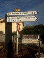
| 👁 Image France
|
On the 👁 way way branching off the junction:
|
The S21 label is a French SU1 symbol, which designates an itinéraire de substitution, a detour route. It is left untreated in the example tagging for lack of consensual tagging scheme for such symbols. |
| File:Svincolo Spinea nell'A4.JPG
Italy
|
On the 👁 way way branching off the junction to the right:
|
|
| 👁 Image United Kingdom
|
On the 👁 way way branching off the junction to the left:
|
Please note the use of *:distance=* with imperial units, as per sign.
|
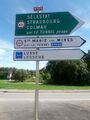
| 👁 Image France
|
On the 👁 way way branching off the junction to the right:
|
Use of conditional restriction necessitated by the complexity of the rule: the right highway is recommended (designated) for goods vehicles
Please note the parenthesis enclosing the successive restriction values of |
| 👁 Image United States of America (NJ)
|
On the 👁 way way branching off the junction to the right:
|
|
| Error creating thumbnail:
France
|
On the 👁 way way branching off the junction to the right:
On the 👁 way
|
Use of conditional restriction necessitated by the complexity of the rule: the left highway is recommended (designated) for goods vehicles whose max allowed weight is above 7.5 metric tons.
The highway branching off to the right has a single |
|
Germany
|
On the 👁 way way branching off the junction to the right:
|
It is up to the destination sign renderer to adapt itself to local sign customs and regulations, and thus to tell that the Neuer Hafen destination is written between the two pictograms, with the access:maxheight pictogram displayed on the destination arrow.
|
|
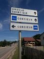
France
|
On the 👁 way way branching off the junction to the right:
|
The two destination restriction indications (here, pictograms) are both mapped as value-condition pairs in the same destination:access:goods:conditional=* tag; their respective order on the sign is followed in destination:access:goods:conditional=*, to allow correct rendering order. Using destination:symbol=* to give their respective order is thus useless.
|
| 👁 Image United Kingdom
|
On the 👁 way way branching off the junction to the right:
On the 👁 way
|
Please note the use of *:distance=* with imperial units, as per sign.
|
| Error creating thumbnail:
France
|
On the 👁 way way branching off the junction to the right:
|
Use of conditional restriction necessitated by the complexity of the rule: the right highway is recommended (designated) for goods vehicles more than 9 meters long.
Please note the parenthesis enclosing the successive restriction values of As some destinations have a |
| 👁 Image United Kingdom
|
On the 👁 way way branching off the junction to the left:
|
The use of destination:symbol=* allows the renderer to guess in which order destination:access:maxheight=* and destination:access:maxweightrating:hgv=* are to be rendered.
Please note the use of |
| File:Panneau D21b fond vert avec idéogramme SC1b.jpg
France
|
On the 👁 way way branching off the junction to the left:
|
Use of conditional restriction necessitated by the complexity of the rule: the right highway is recommended (designated) for vehicles whose max allowed weight is more than 3.5t.
This case of a single |
| File:UK traffic sign 2806.svg
United Kingdom
|
On the 👁 way way branching off the junction to the left:
|
In the UK, this HGV pictogram highlights that the pointed route is recommended for goods vehicles; it is thus a destination restriction indication as per the present tagging scheme.
The black background colour ( |
| 👁 Image France
|
On the 👁 way way branching off the junction to the right:
|
Please note the use of destination:symbol=* to order the restriction pictograms.
|
This only affects https://osm.mueschelsoft.de/destinations/example/index.htm destination signs rendering engines]. It is up to them to manage local regulations such as:
destination:symbol=* not be used for this (particularly in MUTCD-compliant countries);
_at_Exit_10B_(George_Washington_Memorial_Parkway_SOUTH,_Reagan_National_Airport,_Mount_Vernon)_in_Arlington_County,_Virginia.jpg)
,_StVO_1992.svg)
.png)
.png)
.jpg)
.png)
.png)
.svg)
.png)