 |
VOOZH | about |
|
VOOZH | about |
| V・T・E 👁 Image Guildford, Surrey |
| latitude: 51.234683, longitude: -0.577344 |
| Browse map of Guildford 51°14′04.86″ N, 0°34′38.44″ W |
| Edit map |
| 👁 Guildford |
|
| External links: |
| Use this template for your locality |
Guildford is a town in Surrey at latitude 51°14′04.86″ North, longitude 0°34′38.44″ West.
Guildford is a town to the South West of London. It's the County Town of Surrey, even though Surrey CC headquarters are in Kingston (which is no longer in Surrey). It is just outside the London#Yahoo! Aerial imagery coverage.
Jonobennett, Mezzanine and TimSC are mapping this area.
Guildford is mostly traced and tagged but there are many small improvements and tidying to be done.
To do:
If you see any idea needing improving, please list below.
The status of each map region is indicated by a symbol, which describes the type of feature, and a colour, which indicates the completeness of that feature in a map region.
The status is displayed using a template Template:State
{{State|Key=progress}}
| Background colour | Meaning | Use for navigation | To do | value |
|---|---|---|---|---|
| 👁 Image |
The map needs checking, status unknown | Availability unknown | Please check | (None) |
| 👁 Image |
The map contains no or little data | Not to be used | Please complete | 0 |
| 👁 Image |
The map contains partial data | Limited usability | Please complete | 1 |
| 👁 Image |
The map is largely complete (please describe missing data) | Use with restrictions | Please complete (missing data, streets etc.) | 2 |
| 👁 Image |
The map is complete (in the opinion of a mapper) | Suitable for use | Please check and correct any errors | 3 |
| 👁 Image |
The map is complete (verified by 2 mappers) ; please indicate Date when checked) | Suitable for use | Please update as needed | 4 |
| 👁 Image |
This attribute does not exist in the mapped area (e.g. no petrol stations) | Suitable for use | Please update as needed | X |
| Community | District | Status | Remarks | Mapped / Checked by |
|---|---|---|---|---|
| Guildford | Burpham | 👁 Car (3/4) 👁 Labelled (2/4) |
||
| Guildford | Merrow | 👁 Car (3/4) 👁 Labelled (2/4) |
||
| Guildford | Abbotswood | 👁 Car (3/4) 👁 Labelled (2/4) |
||
| Guildford | Town Centre | 👁 Car (3/4) 👁 Labelled (2/4) |
||
| Guildford | Guildford Park | 👁 Car (3/4) 👁 Labelled (2/4) |
||
| Guildford | Onslow Village | 👁 Car (3/4) 👁 Labelled (2/4) |
||
| Guildford | Park Barn | 👁 Car (3/4) 👁 Labelled (2/4) |
||
| Guildford | Westborough | 👁 Car (3/4) 👁 Labelled (2/4) |
||
| Guildford | Stoughton | 👁 Car (3/4) 👁 Labelled (2/4) |
||
| Guildford | Ryde's Hill | 👁 Car (3/4) 👁 Labelled (2/4) |
||
| Guildford | Bellfields | 👁 Car (3/4) 👁 Labelled (2/4) |
||
| Guildford | Slyfield | 👁 Car (3/4) 👁 Labelled (2/4) |
||
| Guildford | South Guildford | 👁 Car (2/4) 👁 Labelled (2/4) |
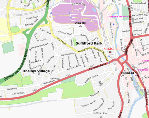
👁 Image
Onslow Village and Guildford Park suburbs, mapping complete