 |
VOOZH | about |
|
VOOZH | about |
| 👁 Image |
| Description |
|---|
| Cars that park in the streets. Places on the tracks where cars are allowed to park. Error creating thumbnail: |
| Group: parking |
| Used on these elements |
| Requires |
|
| Status: deprecated👁 Page for proposal |
| Tools for this tag |
This page documents the usage of the key =* to indicate the physical presence of a parking lane. It can be added to ways tagged with highway=*.
=* is used to express the allowed type or position of parking. Parallel, perpendicular, and diagonal are examples of types of street parking. On-street, on-kerb, and street side are examples of positions of street parking.parking:condition=*, a similar but different tag, is used to describe the legal properties of the parking space. You can use this to tag who can park somewhere (residents, customers, etc.), when they can park, how long they can park, and more.Both can be used independently of each other, they do not necessarily require the other.
=* should always be used with the appended subtags :both, :left, or :right; indicating the of the street they apply to.[1]Parking adjacent to the carriageway (parking:lane:side:type=street_side) can alternatively be mapped as areas with amenity=parking and parking=street_side. Especially in places where the parking situation is very diverse, this can actually be easier to do and easier to maintain than to split the roadway into many small segments just to accommodate for the different parameters that change down the road.
| Example | Tagging |
|---|---|
| File:Barton St view E between South Park Rd and Brown St, Macclesfield.jpg | |
| Error creating thumbnail: |
it is assumed that way is pointing like vehicles, toward us |
| 👁 Image |
it is assumed that way is pointing like vehicles, toward us |
There are more pictures of different roads and how to tag them in Key:parking:lane/Examples.
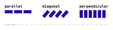
The tag is used to describe the physical properties of the parking (essentially, the orientation) – in other words the types of street parking (and optionally the parking position).
Please note that this tag only describes the space properties, not the actual condition. A parking:condition tag is required in those cases.
The type of parking can be tagged with the key . If there is no parking lane, it is also directly specified as a value.
| Key | Value | Description |
|---|---|---|
parallel |
Deprecated. Use parking:side:orientation=parallel.
| |
diagonal |
Deprecated. Use parking:side:orientation=diagonal.
| |
perpendicular |
Deprecated. Use parking:side:orientation=perpendicular.
| |
marked |
Deprecated. Use parking:side:markings=yes. If possible, be more specific.
| |
no |
Deprecated. Use parking:side=no.
| |
yes |
Deprecated. Use parking:side=yes. If possible, be more specific.
| |
separate |
Deprecated. Use parking:side=separate.
| |
no_parking |
Deprecated. Use parking:side:restriction=no_parking.
| |
no_stopping |
Deprecated. Use parking:side:restriction=no_stopping.
| |
no_standing |
Deprecated. Use parking:side:restriction=no_standing.
| |
fire_lane |
Deprecated. Use parking:side:reason=fire_lane or parking:side:restriction:reason=fire_lane.
|
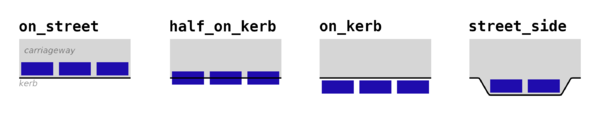
Sometimes the parking on the street is allowed at the edge of the driving lane, at other times there is a painted, dedicated strip at the edge of the road, and sometimes one must park on the high side of the kerb stone.
This can be tagged with the key .
| Key | Value | Description | Image |
|---|---|---|---|
on_street |
Deprecated. Use parking:side=lane.
|
Error creating thumbnail: | |
half_on_kerb |
Deprecated. Use parking:side=half_on_kerb.
|
Error creating thumbnail: | |
on_kerb |
Deprecated. Use parking:side=on_kerb.
|
The left side of Error creating thumbnail: | |
street_side |
Deprecated. Use parking:side=street_side.
|
File:20200925-parking-lined-perpendicular-large.jpg | |
Deprecated. Use parking:side=street_side.
In case you really want to map a lay-by rest area, consider using | |||
painted_area_only |
Deprecated. Use parking:side:markings=yes.
|
||
shoulder |
Deprecated. Use parking:side=shoulder.
|
In many places, it is common to extend the kerb at intersections and crossings to slow down traffic and make it safer to cross for pedestrians. This is tagged as a traffic_calming=choker, it does not make an on_street parking of an entire street into a street_side parking. When there are many chokers in one street, it may become a little hard to distinguish between these two situations in reality.
As a rule of thumb, if the parking cars are on the part of the road that is traversable (i.e. that could and would otherwise be used by traffic) it is parking on_street. If not, it is parking street_side.
Whatever tag value you decide to use in ambiguous situations, it is important to update width=* (or width:carriageway=*) accordingly if it is set because the definitions for those are tied together: The width=* includes the space for on_street parking but excludes the space for street_side parking because the latter count as adjacent to, not on the carriageway.
parking:lane:both=parallel: both on the left and right hand side parallel parking is possible.parking:lane:both:parallel=half_on_kerb: both on the left and right hand side parallel parking is possible, and the parking position is half on kerb (partially on the sidewalk).parking:lane:right=perpendicular: on the right hand side you can park perpendicularly.parking:lane:both=marked: there are only some parking spaces available that are individually marked.parking:lane:both=no: there is no parking lane.Specifying the maximum capacity for a given stretch of parking (especially for parking:lane:side=perpendicular). For parking along the street, this can usually be estimated automatically quite accurately. However, if parking is only possible in dedicated spaces (street_side, painted_area_only), to add such information is potentially more useful.
These taginfo statistics are not representative of all uses of =* or parking:condition=* since they do not account for all possible subtags (e.g. parking:lane:right:parallel=*, etc.).
| Key | :both | :left | :right |
|---|---|---|---|
=*
|
|||
parking:condition=*
|
Data consumers that require precise spatial data on street parking should consider that depending on the local legislation, implicit parking restrictions may exist that are not explicitly tagged with =* etc., so some spatial post-processing may be required. For example, in most legislations throughout the world, parking is prohibited on and about 5 metres around intersections and crossings. Yet, few mappers bother to split up the road the first and last 5 metres of every road to map a no-stopping prohibition. In fact, some even deprecate this practice, as such restrictions are implicit or common sense.
Because parking adjacent to the carriageway can also be mapped as areas, some spatial post-processing may be required anyway. In the case above, some possible parking spaces would need to be cut out around the intersection.
Here is a not necessarily complete list of situations that imply a parking restriction which can be found in many legislations and may not come with explicit tagging:
junction=roundabout, junction=circular should appear on road line in such cases)Most of this is common sense, but software does not know common sense. Also, some of these implicit restrictions may in some countries actually be explicitly signed.
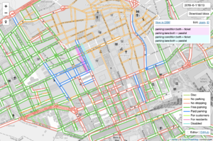
To use these tags correctly, it helps to have visual feedback and contextual tagging assistance available in JOSM. Use of a Map Paint Style and Tagging Presets is highly recommended.
There is a map paint style available called Parking lanes (or possibly a translation of this in the language you use JOSM with). It can be installed via JOSM's Map Paint preferences.
There is also a set of tagging presets available under the same name. These can be installed via JOSM's Tagging Presets preferences.
amenity=vending_machine + vending=parking_tickets=*parking=lane - Parking on the carriageway, including partially on it