 |
VOOZH | about |
|
VOOZH | about |
| 👁 Image highway = |
| Description |
|---|
| Roads mainly / exclusively for pedestrians Error creating thumbnail: |
| Rendering in OSM Carto |
| 👁 Image |
| Rendering in OSM Carto 👁 area |
| 👁 Image |
| Group: highways |
| Used on these elements |
| Implies |
| Useful combination |
| See also |
| Status: approved👁 Page for proposal |
| Tools for this tag |
A highway= is a road or area designated mainly or exclusively for pedestrians. Often found in shopping areas, town centres, places with tourism attractions and recreation/civic areas, where wide expanses of hard surface are provided for pedestrians to walk. It also may be found in residential communities designed to be navigated primarily by foot. Vehicle traffic is generally restricted, with possible exceptions for taxi and delivery services. Cyclists may or may not be permitted, as can be specified by bicycle=*.
In American and Australian English, some pedestrian streets, particularly those located in commercial areas, may be referred to as (pedestrian) malls.
Scope of this tag may overlap with highway=footway, which is generally used for narrower, often unnamed, pedestrian pathways and sidewalks. The distinction between the two may be region-specific. Generally, mappers use tag only on wider streets which might accommodate motor vehicles.
To map a pedestrianised road nothing other than a simple way is required. Add the highway= tag to it and a name=* where applicable to make it complete. Generally, mappers use this tag only on wider streets which might accommodate other vehicles, although distinction from a highway=footway likely varies in definition from region to region.
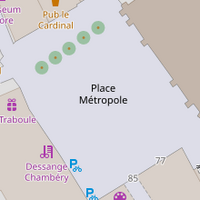
An area (closed way or multipolygon) tagged with highway= + area=yes is the most common way to map the pedestrian area of a square or plaza, where pedestrians can travel freely in all directions. If there are roads passing through the area of the square, map them as usual and make connecting nodes at all intersections with the pedestrian area. Also other paths such as highway=footway as well as roads have to connect with the edge of the pedestrian area where they intersect. [However, note that few routers will route through the area, most will route around the edge of it.]
If there are features or areas within the square or plaza which are not part of the walkable pedestrian area, these should be excluded by creating a multipolygon relation and making them inner members.
Also see the tag place=square for named squares which might include other features, use the pedestrian tag for actual pedestrian areas only. Add a node at the centre of the square or draw the way at the outer limits of the pedestrian area, possibly even connecting with surrounding walls, fences, buildings, etc.
Vehicles may be allowed during special hours to unload merchandise, but are often prevented from entering by bollards.
Cycling may be allowed, depending on the country or local restrictions. If cycling is legal, please add bicycle=yes to make it clear. A riding restriction may be expressed with bicycle=dismount. If even walking/pushing a bicycle is prohibited, use bicycle=no + bicycle:pushing=no.
The F103 roadsign (pedestrian zone) exists in two different flavours: with or without a bicycle logo. Each street is different. bicycle=dismount is the default. Add bicycle=yes on streets where cycling is allowed (F103 roadsign with a bicycle logo).
If you are building a routing algorithm, please take the two following elements into consideration:
highway= is never an obstacle for someone with a bicycle, but mostly a time penalty.Cycling in pedestrian areas not allowed unless specific signs allow it.[1]
Cycling in pedestrian areas is allowed at walking speed in both directions without obstructing pedestrians, unless otherwise stipulated by the police authority, on condition that they maintain a walking pace and do not hinder pedestrians.[2] Access conditions can be specified to avoid ambiguity.
Cycling in pedestrian areas not allowed unless specific signs allow it.[3]
In Italy, access for bicycles to pedestrian areas is allowed by default.[4] If you are mapping in Italy, you are encouraged to explicitly state bicycle=* when mapping highway= in order to avoid ambiguity.
In the United Kingdom, "mews style" housing is a term which may be used to describe urban residential developments which are fronted on a pedestrian street. This term originates from British urban residential areas which were developed to cater to horse and carriage transportation prior to the proliferation of the automobile. In the present day, the term "mews" can be seen in both older communities which have kept their historic name, and in newer communities designed to resemble those pre-automobile developments. The newer developments are often associated with the New Urbanism movement in urban planning. Contemporary mews style housing can take on many different forms and functions, and can be observed in social housing developments, communities designed for the elderly, and private gated communities, for example. Terraced houses are particularly common in "mews style" communities. Note that the presence of the term "mews" in a street, building, or community name is not necessarily an indicator of the current housing and street style in itself, as its use could be a historical holdover that has persisted after the built environment has changed, or a reflection of the whims of a developer unconcerned with the specificity of the description.
| Photo | Tags | OSM-Carto |
|---|---|---|
| 👁 Image |
highway=name=Lloydpassage
|
👁 Image |
| Error creating thumbnail: | highway=area=yesname=Weyher Marktplatzplace=square
|
👁 Image |
| 👁 Image |
highway=access:conditional=delivery @ (00:00-11:00)bicycle=yes
|
|
| 👁 Image |
highway=name=The Mooringsmotorcar=destinationmotorcycle=destination
|
— |
| 👁 Image |
highway=noname=yesCases like this might also be tagged as a footway or a path, depending on the local community’s standards |
https://www.openstreetmap.org/#map=19/50.09722/19.97816 |
| 👁 Image |
highway=name=Fiskergadevehicle=yesnote="Gågade" Pedestrian street with "Kørsel tilladt" vehicles allowed. Driving is allowed here, but (tourist)pedestrians are prioritized higher, so motorists basically can't expect to move faster than the pedestrian in front of them.
Similar to |
area:highway=pedestrian - an area representation of pedestrian streetshighway=footway - for designated footpaths; i.e. mainly/exclusively for pedestriansplace=square - a named square (indicates a town or village square, which is an open public space common in urban centres, such as cities, towns or villages)
| ||||||||||||||||
.jpg)