
We are in the process of migrating all NASA Earth science data sites into Earthdata from now until end of 2026. Not all NASA Earth science data and resources will appear here until then. Thank you for your patience as we make this transition.
Read about the Web Unification Project
Earthdata Search provides sub-second searches through more than 119 petabytes (PB) of Earth observation data in NASA's archive. The application is backed by NASA’s Common Metadata Repository (CMR) and eases the technical burden on users by providing a high-quality tool that makes it simple to discover and interact with Earth observation data created or distributed by NASA.
Earthdata Search and CMR enable search and discovery of NASA Earth observation data as well as data previously only available through the Global Change Master Directory, including data from NOAA, ESA (European Space Agency), JAXA (Japan Aerospace Exploration Agency), and ISRO (Indian Space Research Organization). Please note that some data services available through NASA’s Earth Science Data and Information System (ESDIS) Project may not work with non-NASA partner data.
NASA is a member of the Committee on Earth Observation Satellites (CEOS), and CMR houses tens of thousands of collection records from the dozens of other CEOS member agencies in addition to NASA's Earth Observation Data. These are all made discoverable through an Earthdata Search Portal called the International Directory Network (IDN).
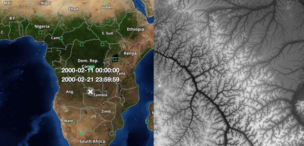
Image Caption
This image from Earthdata Search shows a geolocation map of Africa (left) and a NASA Shuttle Radar Topography Mission (SRTM) image of the Zambia-Democratic Republic of the Congo area captured in February 2000 (right). Earthdata Search offers users the ability to select locations on a map to find corresponding data. The above imagery is part of the NASA Making Earth System Data Records for Use in Research Environments (MEaSUREs) SRTM product developed by NASA’s Land Processes Distributed Active Archive Center (LP DAAC). Credit: NASA's LP DAAC.
Get started with Earthdata Search by creating an Earthdata Login account. An Earthdata Login is required to download NASA Earth science data and provides an improved user experience, including single sign-on, the ability to receive news/notifications on data and services, and greater support for customizable interfaces, context awareness, saved preferences. Once logged in to Earthdata Search, users can download data collections or granules directly or add them to a project profile. (If users cannot find the data they want, they may need to check their Earthdata Login profile for an applicable End User License Agreement, EULA, that must be signed. Most data holdings do not require a EULA, but some do.)
Through Earthdata Search, users can filter datasets labeled as "customizable" to subsets or extract layers before downloading. Data are serviced by the data providers on the back-end, which means Earthdata Search can be a one-stop shop for Earth observation data without the need to go to multiple data providers to request and download data.
Users can save and share their projects and create subscriptions in Earthdata Search to notify them when new data that meet their subscription's parameters are available. In addition, users can customize their own personal Earthdata Search preferences. For example, users can re-configure default settings, such as sorting keys or map views. The Alert bell in the upper right corner of the Earthdata Search main window contains pertinent messages and alerts from data providers, such as when a dataset has an issue or an outage.
With a simple click of a box, end users can filter searches by many data topics and types to find what they're looking for from the more than 54,000 collections (and more than 1 billion distinct data segments or "granules") curated by NASA's Distributed Active Archive Centers (DAACs). Earthdata Search filters include:
- Temporal range
- Science keyword
- Platform
- Instrument
- Processing level
- Data format
- Tiling system
- Horizontal resolution
- Latency
- Whether or not data are cloud-based
- Whether or not data are map imagery
- Ability to customize data
Auto-Populated Search Suggestions
Earthdata Search includes a free-text search bar in the upper left corner of the home page that offers auto-complete suggestions to help find and select the right terms or features.
Search Portals
Earthdata Search has more than a dozen Search Portals, which are instances with a pre-filtered subset of data, usually by topic or project. Search Portals include the Arctic Boreal Vulnerability Experiment (ABoVE), NASA's Oak Ridge National Laboratory DAAC (ORNL DAAC), and the Satellite Needs Working Group (SNWG). Users can easily find and navigate between portals via the Browse Portals option. Additionally, users are free to create their own Search Portal using the Search Portal Creation Guide.
RESTful URLs
Earthdata Search results include RESTful URLs, which are links that include the original search filters and results to be shared with other users.
Ordered Results
Search results can be ordered by:
- Relevance
- Usage
- Start or End Dates
Search results can be viewed as a list or as a table and can be exported as comma-separated value (csv) files. This is especially useful for anyone wanting to spot-check which data are available for a given search criteria.
Helpful Metadata
Metadata are the who, what, when, where, why, and how of archived data. Earthdata Search provides a splash page featuring collection and granule metadata highlights, with the full metadata record or landing page only a click away. Additionally, other associated metadata, such as related collections or applicable analysis tools, are also included in search results. If a tool metadata record is properly configured and associated to a collection, Earthdata Search enables a Smart Handoff that will open a relevant data tool with that particular collection and spatial/temporal filter context pre-populated.
Web-Based Data Visualizations
Earthdata Search uses NASA's Global Imagery Browse Services (GIBS) to provide data visualizations on a web-based map for granule-based visualizations. Even more precise map imagery and thumbnails are available for GIBS-enabled data collections, allowing users to see and further confirm that the data they find are what they need.
Tool at a Glance
Data Tool Type
Search and Discovery
Access
Cataloging
Cloud Computing
Downloading
The VIIRS instrument aboard the NOAA-20 platform captured this image on March 26, 2026.
Worldview Image of the Week
March 27, 2026
The VIIRS instrument aboard the NOAA-21 platform captured this image on March 19, 2026.
Worldview Image of the Week
March 19, 2026
The VIIRS instrument aboard the NOAA-21 platform captured this image on March 10, 2026.
Worldview Image of the Week
March 13, 2026
The OMPS instrument aboard the NASA/NOAA Suomi NPP platform captured imagery and data on March 5, 2026.
Worldview Image of the Week
March 6, 2026
SHOWING 4 OF 161
Earthdata Search Learning Resources
This ARSET training explores the fundamentals of thermal infrared remote sensing and some applications using ECOSTRESS data to analyze urban heat.
Training
May 26 - June 2, 2026
The USGS EROS User Services team is offering an hour-long webinar to share the data, tools, and services available from the Advanced Spaceborne Thermal Emission and Reflection Radiometer (ASTER) instrument aboard NASA’s Terra satellite.
Webinar
March 26, 2026
Join us on Wednesday, Jan. 30, at 2:30 p.m. ET to learn more about NASA's PREFIRE mission datasets, services, and tools.
Webinar
Jan. 16, 2026
This ARSET training explores how the R statistical coding language can be used to classify land cover and quantify changes in land cover over time.
Training
Feb. 24-26, 2026
SHOWING 4 OF 37
Join Our Community of NASA Data Users
While NASA data are openly available without restriction, an Earthdata Login is required to download data and to use some tools with full functionality.
Learn About the Benefits of Earthdata LoginFrequently Asked Questions
Earthdata Forum
Our online forum provides a space for users to browse thousands of FAQs about research needs, data, and data applications. You can also submit new questions for our experts to answer.
Submit Questions to Earthdata Forumand View Expert Responses