
We are in the process of migrating all NASA Earth science data sites into Earthdata from now until end of 2026. Not all NASA Earth science data and resources will appear here until then. Thank you for your patience as we make this transition.
Read about the Web Unification Project
Overview
ESDS data system and science products continuously evolve through a combination of competitive awards and sustained and strategic investments in open data, international and interagency partnerships, and a set of standards that ensure consistency and interoperability. Since 1994, NASA Earth science data have been free and open to all users for any purpose, and since 2015, all data systems software developed through NASA research and technology awards have been made available to the public as Open Source Software (OSS).
ESDS falls within the purview of the agency's Earth Science Division (ESD), under the Science Mission Directorate (SMD) at NASA Headquarters.
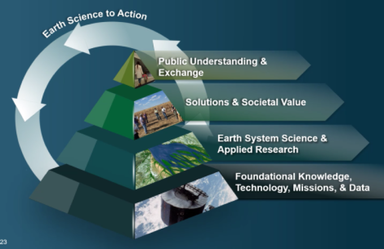
Image Caption
Earth Science to Action Strategy. Credit: NASA
Vision and Goals
Our vision is to make NASA's free and open Earth science data interactive, interoperable, and accessible for research and societal benefit both today and tomorrow.
Our Responsibilities
- Process instrument data to create Earth System Data Records (ESDRs)
- Actively manage NASA’s Earth science data as a national asset
- Uphold NASA’s policy of free, full, and open sharing of all data, tools, and ancillary information for all users
- Engage members of the Earth science community in the evolution of data systems
- Develop data system capabilities optimized to support rigorous science investigations and the unique needs of various scientific disciplines
Our Goals
- Set the standard for efficient production and stewardship of science-quality data
- Advance open science data systems for the next generation of missions, data sources, and user needs
- Lead research and development of technology for management and analysis of complex Earth science data
ESDS Program Elements
ESDS works to achieve its goals by means of several component projects, programs, and partnerships.
NASA's Earth Science Data and Information System (ESDIS) Project manages the science systems of NASA's Earth Observing System Data and Information System (EOSDIS).
Interagency Implementation and Advanced Concepts Team
The Earth Science Data Systems (ESDS) Program's Digital Strategy and User Development Team comprises experts in web development, editorial, graphic design, user experience, and outreach.
NASA's Earth Science Data Systems Geographic Information Systems Team (EGIST) enables the appropriate use and adoption of GIS technology in support of Earth science research.
The Earth Science Data Systems (ESDS) competitive programs provide innovative services to data users offering new scientific insight by engaging external researchers through peer review.
The study team aims to identify the best open-source data processing architecture for NASA Earth science observations.
The Multi-Mission Algorithm and Analysis Platform (MAAP) brings together relevant data, algorithms, and computing capabilities in a common cloud environment to address the challenges of sharing and processing large amounts of data.
I got my PhD degree in vegetation remote sensing by using only a few Landsat images over a relatively very small area. Free access to the satellite data and the availability of supercomputing power really changes the game. I’m very excited to command a huge cluster of computers to do remote sensing work that couldn’t be imaged two decades ago.
Dr. Junchang Ju
NASA Remote Sensing Scientist