 |
VOOZH | about |
|
VOOZH | about |
Longest Coastline in India: India's coastline is a stretch of 7,516 kilometers along the Arabian Sea and the Bay of Bengal. It's essential for trade, fishing, and tourism, supporting the economy and the environment. This article talks about India's long coastline of 7,516 km, explaining its importance. It shares details about each coastal state, their features, and how these areas impact the country economically and environmentally.
| State/Union Territory | Coastline Length (in kilometers) |
|---|---|
| Gujarat | 1,600 |
| Andhra Pradesh | 974 |
| Tamil Nadu | 906 |
| Maharashtra | 720 |
| Kerala | 590 |
| Karnataka | 320 |
| Odisha | 485 |
| West Bengal | 157 |
| Goa | 101 |
| Andaman and Nicobar Islands | 1,962 |
| Lakshadweep | 132 |
India's coasts are very important to the economy of the country because they are home to different plants and creatures that live in them. Different types of coastal areas have various living things, such as coral reefs, seagrasses, mangroves, dunes, lagoons, salt marshes, and estuaries. Cities are developing, there are more people on Earth, and things are changing more rapidly than ever before, that is why they are so unique. The seashore is very useful to support life with a variety of functions and to take care of different kinds of plants and also animals. It is necessary to find a good balance between 'bigger' and 'safer' if India's unique places to be near the sea should keep their precious health for a long time.
| Coastline of India State Wise | |
| State/UT | Indian Coastline Length (in Km) |
| Gujarat Coastline Length | 1214.7 |
| Odisha Coastline Length | 476.4 |
| Tamil Nadu Coastline Length | 906.9 |
| Andhra Pradesh Coastline Length | 973.7 |
| Goa Coastline Length | 101 |
| Maharashtra Coastline Length | 652.6 |
| Kerala Coastline Length | 569.7 |
| Karnataka Coastline Length | 280 |
| West Bengal Coastline Length | 157.5 |
| Andaman & Nicobar Islands Coastline Length | 1962 |
| Lakshadweep Coastline Length | 132 |
| Puducherry Coastline Length | 47.6 |
| Daman & Diu Coastline Length | 42.5 |
| Total Indian Coastline Length | 7,516.60 |
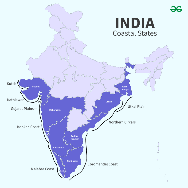
Gujarat has the longest coastline in India, stretching 1214 km in the Kathiawar region. The state is bordered by the Arabian Sea and boasts 41 ports, including one Major and 40 Intermediate ports. Notable beaches in Gujarat include Porbandar, Diu, and Dwarka. The coastline provides economic opportunities through its ports.
Feature | Details |
|---|---|
Coastline Length | 1600 km |
Ports | 41 (1 Major, 40 Intermediate) |
India's Tamil Nadu is its second largest coastal state with a whopping 1,076 km of shoreline on the Coromandel Coast. It's flanked by the Utkal Plains to the north, the vast Bay of Bengal to the east, the fertile Kaveri delta to the south, and the scenic Eastern Ghats to the west. Rich crops like sugarcane, cotton, rice, pulses, and peanuts grow here. Coconuts also abound in this region. The huge Marina Beach, industrious Tuticorin, and bustling Chennai make this region significant with their ports and fishing activities. Additionally, the exquisite Gulf of Mannar National Park raises the region's natural appeal.
Feature | Details |
|---|---|
Coastline Length | 1,076 km |
Ports | Marina Beach, Tuticorin, Chennai (and others), Gulf of Mannar National Park |
The Coastal Andhra region of Andhra Pradesh is the third-largest state in India with a coastline of 973 km. The coastline here is along the Coromandel Coast, from the Bay of Bengal to the Eastern Ghats. It is very fertile due to the Krishna River, Godavari delta, and Penna River, and therefore can provide excellent agriculture. There are many crops grown such as rice, pulses, and coconuts. Moreover, this area has twelve main ports.
Feature | Details |
|---|---|
Coastline Length | 972 km |
Ports | 12 Major Ports |
Among the geographical features of India’s west coast that separate Maharashtra and Goa, one finds the Konkan coast, which is about 720 km long. Bounded by the Western Ghats on the east and the Arabian Sea on the west, Konkan stretches from the Daman Ganga River in the north to the Gangavalli River in the south. The region is well-suited for major crops such as pulses, rice, millet, and coconut, among others. With its fifty-three ports, including two principal ones and fifty-one minor or intermediate ports, it attracts Pune and Mumbai locals through beaches where they can escape from their daily hectic lives.
Feature | Details |
|---|---|
Coastline Length | 720km |
Ports | 53 (2 Major, 51 Minor/Intermediate) |
Located in India, Kerala, known as the Malabar Coast, extends for 590 km and is the fifth-longest coastal area. It starts at the southwestern coast of Maharashtra, passes through Goa, continues along the western coast of Karnataka, and ends at Kanyakumari. Bounded by the Western Ghats to the east and the Arabian Sea to the west, the Malabar Coast is famous for its scenic beauty with landscapes as well as tea and coffee plantations, beaches, and saltwater lakes, among other things. Its 13 major ports add to its economic value, making it an important state.
Feature | Details |
|---|---|
Coastline Length | 590km |
Ports | 13 major ports |
The coast of Odisha, known as the Utkal Plains, extends for about 485 km, making it the sixth-longest coastline in India. It is bounded by the Lower Ganges Plain to the north and the Tamilnad Plains to the south, and is flanked on the west by the Eastern Ghats. Additionally, it is bordered on the east by the Bay of Bengal. The area includes Chilka Lake, the historical kingdom of Kalinga, splendid beaches, and Bhitarkanika. It is worth noting that Odisha possesses only one port.
Feature | Details |
|---|---|
Coastline Length | 450km |
Ports | 1 port |
The Kanara region is a coastal strip that stretches for 300 km and is situated within the boundaries of Karnataka. It is bordered in the north by Konkan, in the south by Kerala Plains, in the west by the Arabian Sea, and in the east by the Western Ghats. Some of the well-known tourist destinations on this coastline are St. Mary's Island Beach and Maravanthe. The area comprises three districts: Udupi, Uttara Kannada, and Dakshina. Along this coastline in India, there are 10 Ports in total and 2 Intermediate Ports.
Feature | Details |
|---|---|
Coastline Length | 309 km |
Ports | 10 Ports, 2 Intermediate Ports |
Goa, the smallest Indian state, has a short coastline of 101 km, known for its beautiful beaches. It's surrounded by Maharashtra and Karnataka, with the Arabian Sea on the west. The soil here is red, alluvial, and earthy, containing ferric aluminum oxides. This coastal soil is rich in minerals and humus, making it good for farming. Goa has one main port and five smaller ones, facilitating trade.
Feature | Details |
|---|---|
Coastline Length | 160 km |
Ports | 1 Major, 5 Minor Ports |
The coastal region in West Bengal spans across Purba Medinipur and South 24 Parganas districts, stretching 158 km. The Sundarbans delta is the world's largest mangrove forest, home to diverse wildlife, notably the royal Bengal tiger. Agriculture is the primary economic sector. Key crops include potatoes, jute, rice, sugarcane, and wheat. The state has a singular port.
Feature | Details |
|---|---|
Coastline Length | 157.5 km |
Ports | 1 port |
India's western and eastern coastlines have unique features. The coastal plains are fertile, allowing for the cultivation of extra crops. The shores, both long and short, have big docks that support trade. The sedimentary pebbles in these areas contain deposits of mineral oil.
Coastal Geomorphology | Percentage |
|---|---|
Sandy Beach | 43% |
Muddy Flats | 36% |
Rocky Coast | 11% |
Marshy Coast | 10% |
Coastline affected by erosion | 1624.435km (mainland), 132 islands (CPDAC) |
Coastal States and UTs population | 560 million |
Population of Island Territories | 0.44 million |