
(Redirected from County of Logne)
Ferrières
Ferire (Walloon) | |
|---|---|
| 👁 Image | |
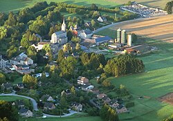
|
👁 Coat of arms of Ferrières Coat of arms | |
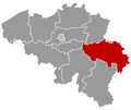
| 👁 Location of Ferrières in the province of Liège Location of Ferrières in the province of Liège | |
Interactive map of Ferrières | |
Location in Belgium | |
| Coordinates: 50°24′N 05°36′E / 50.400°N 5.600°E / 50.400; 5.600 | |
| Country | Belgium |
| Community | French Community |
| Region | Wallonia |
| Province | Liège |
| Arrondissement | Huy |
| Government | |
| • Mayor | Frédéric LEONARD (RpF) |
| • Governing party | RpF |
| Area | |
• Total | 57.06 km2 (22.03 sq mi) |
| Population (2018-01-01)[1] | |
• Total | 4,918 |
| • Density | 86.19/km2 (223.2/sq mi) |
| Postal codes | 4190 |
| NIS code | 61019 |
| Area codes | 086 and 04 |
| Website | www.ferrieres.be |
.svg)
Ferrières (French pronunciation: [fɛʁjɛʁ] ⓘ; Walloon: Ferire) is a municipality of Wallonia located in the province of Liège, Belgium.
On January 1, 2006, Ferrières had a total population of 4,449. The total area is 56.90 km2 with a population density of 78 inhabitants per km2.
The municipality consists of the following districts: Ferrières, My (pronounced "Mee"), Vieuxville (including the hamlet of Sy), Werbomont, and Xhoris.
See also
[edit]References
[edit]- ^ "Wettelijke Bevolking per gemeente op 1 januari 2018". Statbel. Retrieved 9 March 2019.
External links
[edit]- 👁 Wikimedia Commons logo
Media related to Ferrières at Wikimedia Commons
Hidden categories:
- Pages using gadget WikiMiniAtlas
- Pages using the Phonos extension
- Articles with short description
- Short description is different from Wikidata
- Articles containing Walloon-language text
- Coordinates on Wikidata
- Pages using infobox settlement with potentially too many maps
- Pages with French IPA
- Pages including recorded pronunciations
- Commons category link from Wikidata
- All stub articles
- Pages using the Kartographer extension