
👁 File:LunaH-Map.png
Size of this preview: 767 × 599 pixels. Other resolutions: 307 × 240 pixels | 614 × 480 pixels | 983 × 768 pixels | 1,280 × 1,000 pixels | 1,583 × 1,237 pixels.
Original file (1,583 × 1,237 pixels, file size: 843 KB, MIME type: image/png)
This is a file from the Wikimedia Commons. Information from its description page there is shown below.
Commons is a freely licensed media file repository. You can help.
Commons is a freely licensed media file repository. You can help.
Summary
| Description |
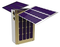
English: LunaH-Map is a 6U CubeSat that will enter a polar orbit around the Moon with a low altitude (5-12km) perilune centered on the lunar South Pole. LunaH-Map carries two neutron spectrometers that will produce maps of near-surface hydrogen |
| Date | |
| Source | http://www.nasa.gov/feature/lunah-map-university-built-cubesat-to-map-water-ice-on-the-moon |
| Author | NASA |
| Other versions |
|
Licensing
| 👁 Public domain |
This file is in the public domain in the United States because it was solely created by NASA. NASA copyright policy states that "NASA material is not protected by copyright unless noted". (See Template:PD-USGov, NASA copyright policy page or JPL Image Use Policy.) | |
Warnings:
|
File history
Click on a date/time to view the file as it appeared at that time.
| Date/Time | Thumbnail | Dimensions | User | Comment | |
|---|---|---|---|---|---|
| current | 00:24, 17 November 2020 | 👁 Thumbnail for version as of 00:24, 17 November 2020 | 1,583 × 1,237 (843 KB) | Yarnalgo | =={{int:filedesc}}== {{Information |description={{en|1=LunaH-Map is a 6U CubeSat that will enter a polar orbit around the Moon with a low altitude (5-12km) perilune centered on the lunar South Pole. LunaH-Map carries two neutron spectrometers that will produce maps of near-surface hydrogen}} |date=2016-02-02 04:45:15 |source=http://www.nasa.gov/feature/lunah-map-university-built-cubesat-to-map-water-ice-on-the-moon |author=NASA |permission= |other versions=[[File:LunaH-Map.jpg|thumb|left|orig... |
File usage
The following 2 pages use this file:
Global file usage
The following other wikis use this file:
- Usage on ar.wikipedia.org
- Usage on de.wikipedia.org
- Usage on ja.wikipedia.org
- Usage on zh.wikipedia.org
Metadata
This file contains additional information, probably added from the digital camera or scanner used to create or digitize it.
If the file has been modified from its original state, some details may not fully reflect the modified file.
| File change date and time | 00:22, 17 November 2020 |
|---|
Retrieved from "https://en.wikipedia.org/wiki/File:LunaH-Map.png"