
Irgoli
Irgòli | |
|---|---|
| Comune di Irgoli | |
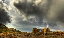
| 👁 Nuraghe sanctuary. Nuraghe sanctuary. | |
Location of Irgoli in Sardinia | |
| Coordinates: 40°25′N 9°38′E / 40.417°N 9.633°E / 40.417; 9.633 | |
| Country | Italy |
| Region | Sardinia |
| Province | Nuoro (NU) |
| Government | |
| • Mayor | Giovanni Porcu |
| Area | |
• Total | 75.0 km2 (29.0 sq mi) |
| Elevation | 26 m (85 ft) |
| Population (31 August 2017)[2] | |
• Total | 2,307 |
| • Density | 30.8/km2 (79.7/sq mi) |
| Demonym | Irgolesi |
| Time zone | UTC+1 (CET) |
| • Summer (DST) | UTC+2 (CEST) |
| Postal code | 08020 |
| Dialing code | 0784 |
| Website | Official website |
Irgoli (Latin: Fanum Carisi, Sardinian: Irgòli) is a comune (municipality) in the Province of Nuoro in the Italian region Sardinia, located about 140 kilometres (87 mi) northeast of Cagliari and about 30 kilometres (19 mi) northeast of Nuoro.
Irgoli borders the following municipalities: Galtellì, Loculi, Lula, Onifai, Siniscola.
References
[edit]- ^ "Superficie di Comuni Province e Regioni italiane al 9 ottobre 2011". Italian National Institute of Statistics. Retrieved 16 March 2019.
- ^ All demographics and other statistics: Italian statistical institute Istat.
Sources
[edit]- Talbert, Richard, ed. (2000). "Map 48". Barrington Atlas of the Greek and Roman World. Princeton University Press. ISBN 978-0-691-03169-9.
Retrieved from "https://en.wikipedia.org/w/index.php?title=Irgoli&oldid=1345070269"
Hidden categories:
- Pages using gadget WikiMiniAtlas
- Articles with short description
- Short description is different from Wikidata
- Articles containing Italian-language text
- Coordinates on Wikidata
- Official website different in Wikidata and Wikipedia
- Articles containing Latin-language text
- Articles containing Sardinian-language text
- All stub articles