
Neve Michael
נְוֵה מִיכָאֵל | |
|---|---|
Moshav | |
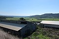
| 👁 Neve Michael from a hill overlooking the Elah Valley Neve Michael from a hill overlooking the Elah Valley | |
| Etymology: "Michael's Haven" | |
Interactive map of Neve Michael | |
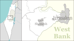
Location of Neve Michael in Jerusalem District, Israel | |
| Coordinates: 31°40′22″N 35°0′22″E / 31.67278°N 35.00611°E / 31.67278; 35.00611 | |
| Country | 👁 Image Israel |
| District | Jerusalem District |
| Regional Council | Mateh Yehuda Regional Council |
| Founded | 29 July 1958 |
| Founded by | Kurdish Jews |
| Population | |
• Total | 975 |
Neve Michael (Hebrew: נְוֵה מִיכָאֵל, lit. 'Michael's Haven')[2] also known as Roglit, is a moshav in central Israel. Located in the Adullam region and built upon an eminence in the far south-east end of the Elah Valley, it falls under the jurisdiction of Mateh Yehuda Regional Council. In 2024 it had a population of 975.[1]
Background
[edit]Archaeology
[edit]Archaeological finds range from the Early Hellenistic period to the Umayyad period with evidence of a Jewish settlement in the first century CE.[3]
Near the moshav are the ruins of Adullam and Hurvat Itri.
Arab village
[edit]The moshav was preceded by the Palestinian Arab village of Bayt Nattif, which was depopulated during the 1948 Arab–Israeli War. [4] The place where the moshav stands was known in the 19th century as Khirbet Jurfah.[5]
Moshav history
[edit]Roglit
[edit]The village of Roglit was established on 29 July 1958 (12 Av 5718 anno mundi) by a group of Jewish immigrants from Iranian Kurdistan, on farm land that had belonged to Bayt Nattif.[6][4] In 1958, the newly restructured Jewish National Fund (JNF), working in concert with the Hitahdut HaIkarim agricultural organisation, settled new immigrants on the site giving to the place the name Roglit (Hebrew: רוֹגְלִית), meaning "tiller [of the grapevine]".[citation needed] The new immigrants were initially employed as laborers for JNF land reclamation.[citation needed] The founders were joined by immigrants from North Africa, mainly Morocco.[6]
An Israel Border Police outpost was also built[when?] in Neve Michael,[clarification needed] which was later abandoned in 1962[dubious – discuss].[citation needed]
After the JNF-related years, the village[which?] economy was based on agriculture (citrus fruit) and poultry, which phased out in the late 1980s.[citation needed]
Neve Michael
[edit]A newer[when?] regional community center built alongside it[citation needed] was given the name Neve Michael, in memory of American philanthropist, Michael M. Weiss,[7] who was a donor to the JNF.[citation needed] The newer section had a regional elementary school which catered to children from the surrounding communities of Roglit, Aderet and Aviezer, but closed its doors in the early 1980s.[citation needed] Today, the grounds of the old school serve as a home for the mentally and physically disabled.[8]
1983 merger; new Neve Michael
[edit]When the new settlement of Neve Michael failed to attract new residents, it was merged with Roglit in 1983.[8]
In 2005 the village started an expansion plan attracting many younger families to the moshav. The moshav has a mixed population with people of different ages, ethnic background and Jewish religious observance.[citation needed]
Gallery
[edit]-
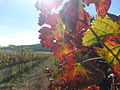
Vineyard at Neve Michael
-
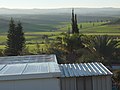
View of Valley from the Moshav
-
Sunrise over the Elah Valley
-
Houses in Neve Michael
-
Terebinth tree (Pistacia atlantica) in the Elah valley, on south side of Neve Michael
-
Beneath the shady boughs of a terebinth
-
Terebinth (Pistacia atlantica) growing in the Elah Valley
-
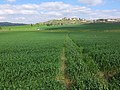
Wheat fields in the Valley of Elah
-
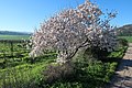
Almond tree with blossoming flowers
-
The Community Center in Moshav Neve Michael
-
Neve Michael looking out over Wadi Sur
-
Moshav as seen from eastern mountain
-
Wheat fields in valley
-
Dominican sage (Salvia dominica) and Neve Michael in background
,_in_Israel.jpg)
.JPG)
.jpg)
.jpg)
See also
[edit]- Giv'ot Eden, community settlement south-east and within walking distance of Neve Michael
References
[edit]
- ^ a b "Regional Statistics". Israel Central Bureau of Statistics. Retrieved 21 March 2026.
- ^ English translation follows the Judeo-Arabic translation of the Hebrew "neve" = מאוא (مأوى), in Jeremiah 50:7, published in Yosef Tobi's Poetry, Judeo-Arabic Literature and the Geniza, Tel-Aviv 2006, p. 59 (Hebrew)
- ^ Avner, Rina (2006). "Rogelit". Hadashot Arkheologiyot: Excavations and Surveys in Israel. 118. Israel Antiquities Authority.
- ^ a b Khalidi, Walid (1992). All That Remains: The Palestinian Villages Occupied and Depopulated by Israel in 1948. Washington D.C.: Institute for Palestine Studies. p. 212. ISBN 0-88728-224-5.
- ^ In the Survey of Western Palestine (Arabic and English Name Lists), London 1881, p. 307, E.H. Palmer calls the site Khŭrbet Jurfa. According to Payne-Smith's lexicon of the Aramaic/Syriac language, the name "Jurfa" (ܓܘܪܦܐ), means "a cutting or slip of the olive-tree; a hollow in a tree." See Payne Smith, J. (1903). A compendious Syriac Dictionary: founded upon the Thesaurus Syriacus of R. Payne Smith (in Syriac and English). Oxford: Clarendon Press. OCLC 251355373., p. 66.
- ^ a b "About Moshav Neve Michael". homee.co.il (in Hebrew). Retrieved 9 January 2026.
- ^ Stone Monument in Neve Michael, in memory of Michael M. Weiss; Plaque in recognition of Michael M. Weiss
- ^ a b Hareuveni, Imanuel (2010). Eretz Israel Lexicon (in Hebrew). Israel Ministry of Education and The Center for Educational Technology (CET). p. 862. Retrieved 9 January 2026.
External links
[edit]- Rogelit in Antiquity Archaeological Survey of Israel
- Pages using gadget WikiMiniAtlas
- CS1 foreign language sources (ISO 639-2)
- CS1 Hebrew-language sources (he)
- Articles with short description
- Short description is different from Wikidata
- Pages using infobox mapframe without shape links in Wikidata
- Coordinates on Wikidata
- Articles containing Hebrew-language text
- All articles with unsourced statements
- Articles with unsourced statements from January 2026
- All articles with vague or ambiguous time
- Vague or ambiguous time from January 2026
- Wikipedia articles needing clarification from January 2026
- All accuracy disputes
- Articles with disputed statements from January 2026
- All articles with specifically marked weasel-worded phrases
- Articles with specifically marked weasel-worded phrases from January 2026
- Articles with unsourced statements from August 2018
- Articles with unsourced statements from November 2017
- Commons category link is on Wikidata
- Pages using the Kartographer extension