
You can help expand this article with text translated from the corresponding article in French. (May 2014) Click [show] for important translation instructions.
|
Walschbronn | |
|---|---|
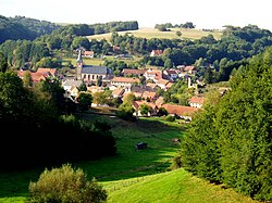
| 👁 A general view of Walschbronn A general view of Walschbronn | |
|
👁 Coat of arms of Walschbronn Coat of arms | |
Location of Walschbronn | |
| Coordinates: 49°08′57″N 7°28′55″E / 49.1492°N 7.4819°E / 49.1492; 7.4819 | |
| Country | France |
| Region | Grand Est |
| Department | Moselle |
| Arrondissement | Sarreguemines |
| Canton | Bitche |
| Intercommunality | Pays de Bitche |
| Government | |
| • Mayor (2020–2026) | Christian Schwalbach[1] |
Area 1 | 10.11 km2 (3.90 sq mi) |
| Population (2023)[2] | 384 |
| • Density | 38.0/km2 (98.4/sq mi) |
| Time zone | UTC+01:00 (CET) |
| • Summer (DST) | UTC+02:00 (CEST) |
| INSEE/Postal code | 57741 /57720 |
| Elevation | 247–387 m (810–1,270 ft) (avg. 320 m or 1,050 ft) |
| Website | www.walschbronn.fr |
| 1 French Land Register data, which excludes lakes, ponds, glaciers > 1 km2 (0.386 sq mi or 247 acres) and river estuaries. | |
.svg)
Walschbronn (German pronunciation: [valʃbʁɔn]) is a commune in the Moselle department of the Grand Est administrative region in north-eastern France.
The village belongs to the Pays de Bitche and to the Northern Vosges Regional Nature Park.
Population
[edit]| Year | Pop. | ±% p.a. |
|---|---|---|
| 1968 | 552 | — |
| 1975 | 539 | −0.34% |
| 1982 | 532 | −0.19% |
| 1990 | 478 | −1.33% |
| 1999 | 525 | +1.05% |
| 2007 | 548 | +0.54% |
| 2012 | 495 | −2.01% |
| 2017 | 497 | +0.08% |
| Source: INSEE[3] | ||
See also
[edit]References
[edit]- ^ "Répertoire national des élus: les maires". data.gouv.fr, Plateforme ouverte des données publiques françaises (in French). 2 December 2020.
- ^ "Populations de référence 2023" (in French). National Institute of Statistics and Economic Studies. 18 December 2025.
- ^ Population en historique depuis 1968, INSEE
External links
[edit]- 👁 Wikimedia Commons logo
Media related to Walschbronn at Wikimedia Commons
Hidden categories:
- Pages using gadget WikiMiniAtlas
- CS1 French-language sources (fr)
- Use dmy dates from August 2023
- Geography articles needing translation from French Wikipedia
- Articles with short description
- Short description is different from Wikidata
- Coordinates on Wikidata
- Pages with German IPA
- Commons category link is on Wikidata
- Moselle communes articles needing translation from French Wikipedia
- All stub articles
- Pages using the Kartographer extension